Copyright © Panorama Group 1991 - 2024

In KB "Panorama" the version 6.13.0 has been developed for operating systems Astra Linux, CentOS, Ubuntu, MS Windows. The new version has improved map editing tools, data analysis tools, and expanded capabilities of the application's web interface.
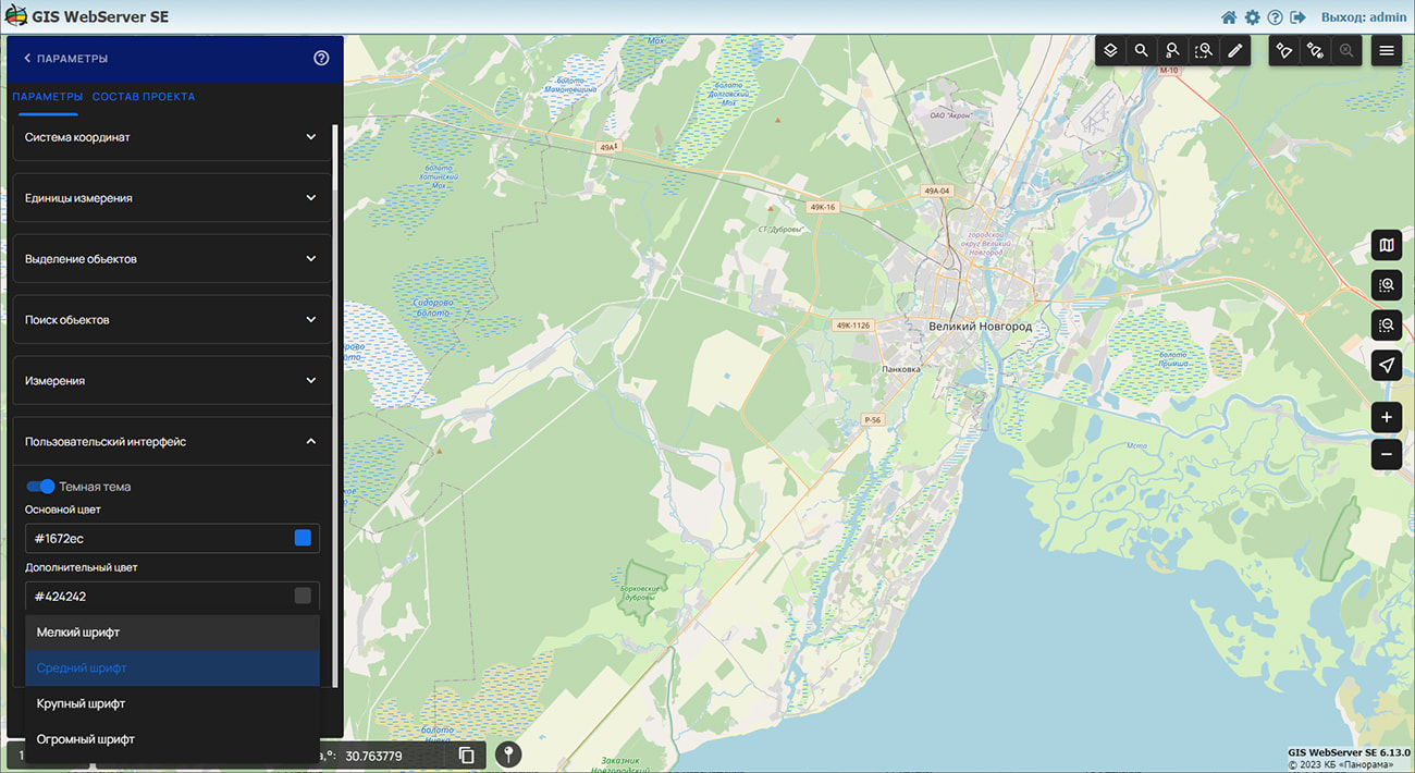
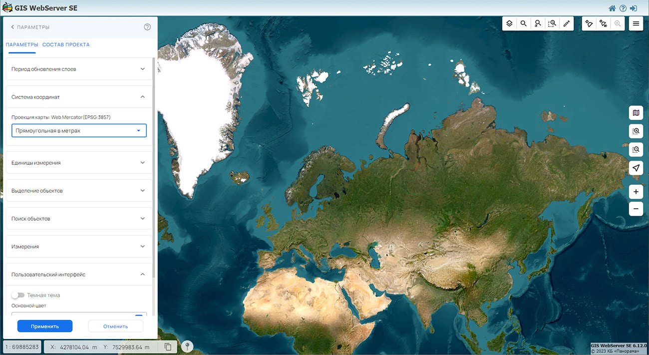
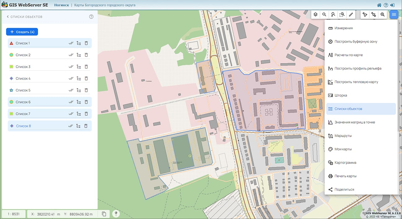
Component the Map label has been added, the Map Editor and the administration module have been improved. The component the Map label allows to create personal marks on a map and to bind the note text to them. The user can put the waypoints of his own movements, leave a note about the state of the area in the specified location, mark and comment on tourist places, event places, create their own guides or map design elements. Sets of labels are displayed in the map as local layers, information about the location of labels and their description is automatically saved by the user. The data of labels can be re-rendered in the map, downloaded as GeoJSON and CSV data format, or deleted. In the Map Editor, the Edit point mode has been updated - when changing the coordinates of an edited point, the ability to coordinate common points of neighboring objects has been added. In the Map objects component, for the convenience of information perception, the output of information about objects in a tabular form has been added. The updated Settings component provides the ability to use a dark theme in the application web-interface and select the font size for form elements.
GIS WebServer SE is used in the construction of closed corporate systems to ensure the protection of data having a security classification or a trade secret. The program is certified by the 2nd level of control over the absence of undeclared capabilities. GIS WebServer SE is implemented using the , which can be used in development tools that use the JavaScript and TypeScript.
On the basis of GIS WebServer SE and other the has been implemented. RGIS RО is a specialized multifunctional geoportal, the interactive capabilities of which provide access to reliable information about objects of various categories. RGIS RO is available to a wide range of users - to the authorities, citizens, organizations, including potential investors and private companies. The regional GIS of the Ryazan region helps in making decisions in various areas of socio-economic development.
New version of the program is posted on the website in the section.


In KB "Panorama" the for Aurora OS version 1.2 has been developed. The new version adds tools for editing spatial data and performing geodetic calculations.
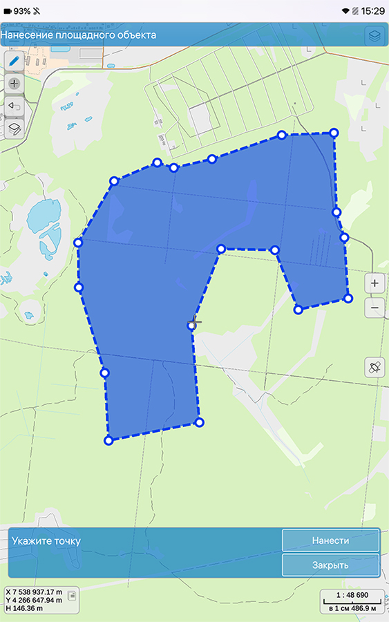
The new mode of editing the vector data has been added. Using this mode, the user can specify the coordinates of objects of interest to him on the ground (for example, cadastral plots, objects of power grids or gas economy). As data for editing, the user can select any open layer available for editing. The user can choose the external view of an object and a set of its characteristics from a standard library of conventional symbols (classifier) depending on the used subject (topographic, navigation, agricultural or forestry maps, etc.). When working with the classifier,the user can execute selection by a set of conditions: object type (for example, point or area) and object layer (for example, "Vegetation" or "Road network"). Information received from the built-in navigation device can serve as a source of information about the position of a terrain object. For convenience of using, a cancellation of last operation on map editing has been provided.
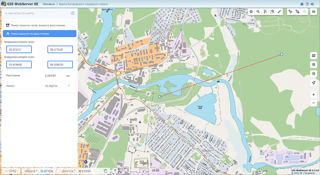
Direct and inverse geodetic tasks for execution of calculations on the terrain map have been implemented. Using these modes, the user can determine the coordinates of an object by a set of computational properties (starting point, distance, and azimuth). The selection of the starting point is carried out in an interactive form, it is supported the entering the coordinates from the keyboard in meters, in the current projection of the map. Calculation results can be displayed on a map or presented in numerical form. The received coordinates can be copied to the device's clipboard and used for transmission or further processing. For quick navigation, the ability to position the map window to any open spatial data layer has been added.
GIS "Panorama Mobile" allows you to open and edit the main formats of digital maps of GIS "Panorama" and popular geoportals on mobile devices based on the Aurora OS, to process information from the built-in GPS/GLONASS receiver. The user can prepare in advance a necessary set of spatial data in one of desktop products (GIS "Panorama", Panorama-editor, GIS Panorama Mini) and to transfer it into the mobile GIS "Panorama Mobile". The process of working with data is carried out autonomously, without connecting to the Internet. When the user moves, his current position is dynamically displayed according to the coordinates obtained from the GPS/GLONASS receiver. For ease of use, it is possible to synchronize the position of the map with the current location. To save the coordinates obtained during movement, a track recording mode is provided, which creates a separate map and puts the trajectory of movement onto it. For all objects of a map during the work the basic information is provided . The program is developed on the basis of the GIS Constructor toolkit, which provides components for creating mobile applications for working with digital maps in the C++ programming language using the Qt.
- is a Russian mobile operating system developed by the "Open mobile platform" company. It has been created to build a trusted mobile infrastructure, protect sensitive information in government organizations, large and medium-sized commercial companies. Contributes to ensuring the technological sovereignty of the state through a secure mobile environment and meets all the requirements of regulators in the field of national security and information protection. Aurora OS allows centrally to operate the base of mobile devices and the used mobile software at use of Aurora Center. The current version of the Aurora mobile OS has been certified by the FSTEC of Russia and fully complies with the requirements for type "A" operating systems of 4 protection class and 4 trust levels.
The new version of the program is available for download in the section.


In KB "Panorama" the version 15.3.0 has been developed.The new version adds support for a new standard - OGC 14-065r2 Web Processing Service version 2.0.2 (OGC WPS). In many cases, geospatial or location data, including data from sensors, data from drones, and other data, must be processed before the information can be effectively used. In most cases process of preliminary data processing can take a long time and require significant resources from the server. This standard provides an the interface for execution of simple and difficult computing methods of processing of the information. The OGC WPS standard supports both immediate processing of operations that require little time for execution, as well as asynchronous processing for more complex and time-consuming tasks. OGC WPS standard defines the general model of process and provides a description of the processing functions and their parameters. It is intended for support of cataloging and detection of processes in the distributed environment. Using the model of the OGC WPS standard, the service allows you to receive/issue parameters, both by direct value and through links, for example, the results of previous operations or data from other services.
For OGC WPS, all operations available in the standard are supported: GetCapabilities, DescribeProcess, Execute, GetStatus, GetResult, Dismiss. Based on OGC WPS, all asynchronous information processing methods already available in the service are standardized, such as: checking intersections between objects of different layers; construction of intersections between objects; updating the data cache; building visibility zones; building matrixes of heights; construction of thermal and thematic maps and others. Using the commands of the standard, you can run any other requests supported by the service in synchronous or asynchronous modes. Descriptions of requests and their parameters can be obtained from the OGC WPS specification - GetCapabilities/DescribeProcess requests, and from the OpenApi 3.0 specification - a universal interface for users (clients) to interact with services (servers).
GIS WebService SE supports all international standards (OGC WFS, WFS-T, WMS, WMTS, WCS, WPS), which are used to transfer and display spatial data. The program implements the ability to issue tiles according to any user or local coordinate system. The application is implemented on Windows and Linux platforms and is compatible with Apache, IIS and nginx web servers.
The new version of the program and the documentation are placed on the website in the section.

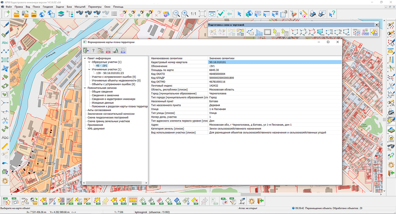
Specialists of KB "Panorama" have prepared a video lesson on using the mode. Dialog is intended for creation of the electronic document "a territory Map-plan" in which reproduces necessary for placing into EGRN an information about land plots located within the boundaries of the territory where complex cadastral works are performed, as well as information about the location of buildings, structures, objects under construction on such land plots.
The initial initialization of the dialog content is performed by information from the digital cadastral map and from the database of cadastral works. The cadastral map for the formation of a map-plan of the territory should be prepared in accordance with the .
The map should be created with use of survey.v5 or survey.v6 classifiers. To draw objects in respect of which cadastral works are performed, it is necessary to use the objects of the "Cadastral plan of the territory" layer. An exception is the point object "Contour of the construction, OHS off-scale round" (key P_REALTYROUND), used for drawing point objects of real estate, which is located in the "Technical plan" layer.
The territory of execution of complex cadastral works should be digitized by the line of borders including all objects of cadastral works. An object within which complex cadastral works are performed can be of two types - "Cadastral block" (key S_BLOK) or "Boundary of complex cadastral works" (key S_CADASTRE). For an object of the first type, the semantics "Cadastral number" (key KADNUM) must be filled in, for an object of the second type - the repeating semantics "Cadastral number of the block" (key KADNUM_K).
You can get acquainted with the training materials in the "Video lessons" section.


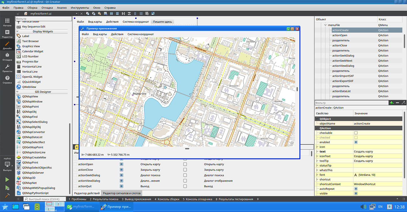
In KB "Panorama" the for Qt Designer SE version 14.3.0 has been developed. In the new version the universal interface of interaction with graphic libraries has been implemented, mechanisms of work of the program in the conditions of the limited system resources have been improved. The list of supported geoportals has been expanded, the display of sea maps has been improved, and new diagnostic capabilities of working the GIS applications have been added.
A programming interface has been developed that allows the developer to use a graphics library for visualization based on his needs. The central element of most GIS applications is the display of spatial data. In this case, the image of a fragment of a digital map is formed using the functions of drawing graphic primitives (lines, polygons, points, and others) by means of a certain graphic library (Qt, GTK, wxWidgets, Xlib, and others). Often the choice of such a library is already determined at the design stage of the application and is a permanent part of the architecture. GIS Constructor provides software tools for implementing data visualization in an application with any selected graphic framework. This is achieved by separating the implementation of displaying graphic primitives into a separate library, which is accessed by the GIS core during the drawing process. As a result, the developer can use either a ready-made set of drawing functions, or implement them independently based on the graphics framework of interest to him. This makes GIS Constructor a universal tool for visualizing spatial data. The installation of the program includes examples of the implementation of drawing graphic primitives based on the Qt and Xlib libraries.
The functioning of the GIS application has been improved with a limited amount of available RAM. The need for the program to work in conditions of a small amount of system resources becomes relevant when using the embedded devices, portable laptops, specialized tablets and other similar devices. If there is a lack of memory, the GIS core automatically activates a buffer with a limited amount of memory and performs all operations with data using only this buffer. As a result, memory consumption by the GIS application is drastically reduced. The new version adds the ability to explicitly set a limit on the amount of memory used by the application for opening the data, when it is reached, this mode will be activated forcibly.
The ability to display only error messages in the diagnostic protocol has been added. This allows you to effectively determine the cause of abnormal behavior of a program that performs a large number of operations with spatial data. In this case, limiting the output by error messages reduces the volume of the resulting protocol and makes it convenient for further analysis.
The task of connecting geoportals has been improved. Into the list of geoportals the geoportal of Krasnodar territory has been added containing the layers: Administrative territorial division, Contours of fields of agricultural land, Fishing grounds, Vine plantations
Display of sea maps according to the S52 standard has been improved. There is clarified the implementation of procedures for forming depth values based on attribute values for underwater obstacles, taking into account the underlying objects, a requesting the code of the displayed symbol and the display flag taking into account the depth of the obstacle and requesting the code of an isolated underwater hazard with a depth less than the safety contour.
GIS Constructor is a set of geoinformation components for use in the visual programming environment of Qt Designer, which allows you to develop your own GIS applications. The visualization of the contents of digital maps is made in conventional symbols adopted for topographic, geographical and various special maps. Geoinformation system has ample opportunities for performing calculations, for providing display of spatial data on various graphic devices in standard and user systems of conventional symbols. The main functions can be executed in multithreaded mode. It supports automatic optimization of used memory for processing large amounts of data (tens of gigabytes) on limited resources (hundreds of megabytes).
The toolkit is adapted for work on a wide range of operating systems (Astra Linux SE, ALT Linux, Elbrus, Ubuntu, CentOS, QNX) and architectures (Intel, Elbrus, PowerPC, SPARC, ARM). The toolkit includes components of visual designing the GIS applications and library of a multiplatform multithreaded GIS core. GIS Constructor provides a cross-platform MAPAPI interface that allows a programmer to implement development in an operating system convenient for it. The developer can release GIS applications for a set of operating systems by simple assembly with minimal changes to the program source code.
The new version of the program is available for download in the section.


Ph.: +7 (495) 739-0245, +7 (925) 221-1603
www.gisinfo.ru | panorama@gisinfo.ru
105005, Russia, Moscow, Baumanskaya Street 7, building 1, office 229 (m. Baumanskaya)
Copyright © Panorama Group 1991 - 2024


 Mobile version
 Full version