Copyright © Panorama Group 1991 - 2024

Specialists of KB "Panorama" have prepared a video lesson on using the mode. The considered mode is available to users in the program.
This dialog is used to view information about a single object, consisting of one or more parts. The mode displays the distribution of the numerical values of the characteristics over different parts of the object and its general measuring properties. For example, for a highway, the number of lanes, pavement material, speed limit, slope, and other properties may change. Sections of the road, where the properties are constant, can be digitized by separate objects. Different sections can be logically linked into a single road due to the common property the Road number, Own name or Designation.
You can get acquainted with the training materials in the "Video lessons" section.


In KB "Panorama" the version 6.12.0 has been developed for operating systems Astra Linux, CentOS, Ubuntu, MS Windows. In the new version, the tools for editing and analyzing the location of map objects have been expanded, measurements on the map and the administration module have been improved.
In the Map Editor new tools of objects geoprocessing - the modes have been added: Copy to another map, Creating a subobjects, Cutting of linear object into several objects. Remote editing of objects allows to receive more exact and updated information in the multiuser mode, and also to create the new data inaccessible before. In regional or corporate portals, the location analysis of objects helps to identify areas of interest or places where urgent action needs to be taken from the map. For example, quickly to display places of rivers floods, to mark areas of roads repairing, communication lines or power grids. The Measurements component has been improved. Now you can create several measurements with saving the results after closing the mode.
GIS WebServer SE is used in the construction of closed corporate systems to ensure the protection of data having a security classification or a trade secret. The program is certified by the 2nd level of control over the absence of undeclared capabilities. GIS WebServer SE is implemented using the , which can be used in development tools that use the JavaScript and TypeScript.
On the basis of GIS WebServer SE and other server products of KB "Panorama" the has been implemented. RGIS RО is a specialized multifunctional geoportal, the interactive capabilities of which provide access to reliable information about objects of various categories. RGIS RO is available to a wide range of users - to the authorities, citizens, organizations, including potential investors and private companies. The regional GIS of the Ryazan region helps in making decisions in various areas of socio-economic development.
New version of the program is posted on the website in the Download section.


Specialists of KB "Panorama" have prepared and placed the map of the Chelyabinsk region on the geoportal . The map was formed using OpenStreetMap data. To work with the map, you can use the program or other software products of KB "Panorama".
The map was led to the modernised classifier of large-scale plans of scale 1: 5 000 (map5000m) and was saved into a packed project (MPTZ). The MPTZ format project includes a digital map of the region's territory (country, subject of the federation, administrative region), a map of the administrative-territorial division of the region and a digital classifier. Publishing of updates in bank of spatial data is made by using the program of . Publishing contents of bank of spatial data on the geoportal and data access for downloading are implemented by means of .
Free maps on the basis of OpenStreetMap data are available for download on the page "Digital maps".


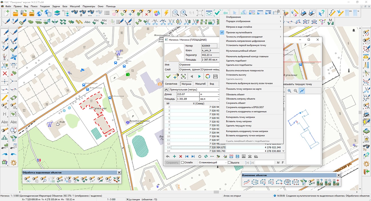
Specialists of KB "Panorama" have prepared a video lesson of using the mode . Users can use this mode in the , or "Workstation of cadastral engineer".
The task considered in the training material is intended for creation by marked objects of multipolygons, multilines or multipoint objects, depending on type of selected objects - the areal, linear or point. The metric of the selected objects is combined into one object with common semantics, and the processed objects are deleted. Uniting of metric is performed only for objects that have the same classification code as the first selected object.
You can get acquainted with the training materials in the "Video lessons" section.


In KB "Panorama" the GIS Panorama Mini version 14.5.5 has been developed. In the new version the possibility of requesting the information from databases of external information systems via web protocols has been implemented. Connection of bases of spatial data was simplified. Import and export of DXF format and import of DGN format has been improved. The tools for managing the display of sea maps of the S52 standard have been implemented, taking into account the characteristics of a vessel with a navigation system, the possibilities of using TrueType fonts as the signs for filling polygons or designing linear objects have been expanded. The task, which controls the logical structure and classification system of vector map data, has been completely updated. Tools for displaying rasters and matrixes with compression, formations of file PostScript CMYK have been refined. Display of graphics by adding the ability to directly open graphic files has been accelerated.
The possibility of requesting information from databases of external information systems via web-protocols has been implemented. ("1С: Enterprise" and others) allows to use the data from these systems as the additional attributive information for displayed territory. For example, the information base "1C: Enterprise" contains information on accounting objects - land plots and buildings, their lease payments, lease terms, types of permitted use and other indicators that can be displayed in the GIS in logical connection with vector map objects and/or spatial database.
Access to external information systems is carried out using the HTTP protocol. The response from the system is a data set in XML format, which is provided to the GIS user in the form of a table in a separate dialog box.
The dialog provides various interactive modes of operation: search on the map for an object corresponding to the current record, and vice versa - search for a record in the table for the current map object; setting filters for displaying data in the table with the ability to select objects on the map that meet the filter conditions; filtering records in the table by selected map objects; viewing the selected table record in a separate dialog box; export of the table to *.csv file and others.
Link of records of a data set from an external source with map objects is carried out according to the value of the key field and the predefined semantics of the object, which is specified in the settings. For example, information on real estate objects in the 1C database can be associated with map objects by cadastral number.
A map of land plots and buildings and the configuration of the "1C:Enterprise" information base containing information on these land plots and buildings have been added into the demo data included in the GIS installation. In the configuration of information base a publication has been prepared using the OData protocol for directories and contains an example of program formation of the XML-response to a request to an HTTP service.
When (DBM-projects) from one spatial database the repeated requests for user authorization are excluded. The diagnostic protocol of connection to a spatial database for the analysis of errors in the data has been refined.
In the main menu "View" the item has been added, taking into account the features of the vessel on which the navigation system is installed. When this menu item is selected, a dialog is called up in which you can change the parameters for displaying sea maps: safe depth, safety contour, shoal contour, depth contour, depth gradation, shallow filling, isolated dangers in shallow water, language of displayed titles.
When importing S57 sea maps, support has been added for datasets with sea map updates (ER profile), which are located in files with extensions 001, 002, 003, and so on.
Files of updatings should take place together with an initial data set with expansion 000 in one folder or according to structure of folders under standards . The update files must be placed together with the source data set with extension 000 in the same folder or in accordance with the structure of folders according to the IHO S57/S63 standards. The names of the source dataset and update files must match.
In the tasks of and of data in the DXF format, a saving and reading of colors of conventional symbols of objects in RGB format has been implemented. The RGB color model covers a wider range of colors and provides the highest color rendering compared to the previously used AutoCAD indexed color palette. Into dialog "Export a map to DXF file" the possibility has been added for customizing a processing of all open maps at enabling the option "Process all maps" that allows you automatically to export the data of each map to a separate DXF file.
There is added a recalculation of coordinates and sizes of characters from storage units specified in DXF: inches, feet, miles, millimeters, centimeters, meters, and so on. The formation of graphic primitives from the parameters of conventional symbols specified in DXF has been improved, which allows you to reproduce the view of the original drawing without setting the symbols.
In dialog the mode "Create a set of maps" has been added which is intended for automatic processing a large number of selected data and creating a separate user map for each DXF file. As a result of the task execution, the list of the generated maps is saved in project MPT.
In the task the possibility has been implemented for creating objects which are described in the source file as a complex chain. As a result, the elements of each chain are transformed into a single object. The dialog interface has been updated to automatically process a lot of selected data and create a separate user map for each DGN file.
A new version of the "Classifier Editor" task has been developed. In the tab, information about the composition of the classifier is supplemented by the number of connected libraries with user symbols. There is added the tool for translating the names of layers, objects and semantics of the classifier into other languages. Working with color palettes of the classifier is placed on a separate tab "Palette". There is a convenient opportunity to simultaneously view and work with the colors of RGB and CMYK palettes. In the tab there are added the tools of search for objects by name, code, symbolical code, a key and other properties through the "Objects Content". In the tab in the tree of user functions for displaying objects, next to the name of the function, the number of types of objects in which it is used has been added. In the tab, the display of the full set of characters of the selected font has been added.
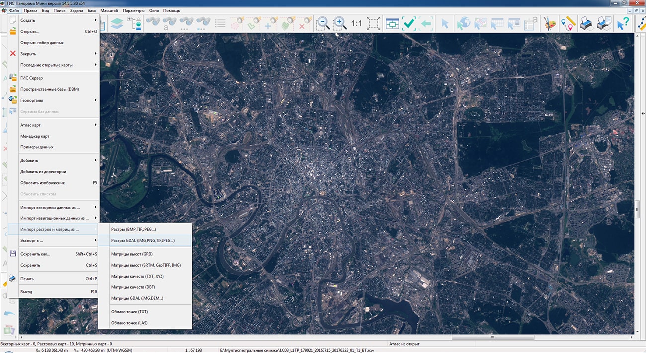
Possibility of direct opening of graphic files has been implemented without the dialog for converting to RSW through the File-Open menu, for quick access to various terrain images. When graphic files are opened for the first time, a service RSW file is automatically created without copying the image and a TAF file with a pyramid of thumbnails, if they were not in the source file. To work with large images, it is recommended to open files with the image converted to RSW format via menu the File - Import rasters or matrix. This will speed up the display of graphics, allow you to process a large number of files of arbitrary sizes with a limited memory area, and speed up the conversion of image projections on the fly.
has been added. At increase in the image of a raster more than in 2 times from the initial size in pixels a smoothing is carried out. The new display algorithm allows you to get rid of the "pixelation" effect when you increase the rasters. Management of smoothing is carried out via the main menu: View - Enlarged raster with smoothing.
has been refined: accounting for the colors of the palettes of all open maps has been added, processing of gradient fills has been added. PostScript files are created in the map printing dialog, which is called via the main menu: File - Print. To print the map in PostScript, you must select a PostScript-compatible printing device and output type: PostScript RGB or PostScript CMYK.
The task of has been improved. For the geoportal of Rosreestr "Land plots", the range of data display scales has been expanded to 1:1 - 1:50 000. To be able to view an overview view, data from larger scales with image compression is requested.
The algorithm of compression of the data of a matrix of heights has been improved. Functions have been refined: compression of 16-bit data has been added. This algorithm is used when loading a matrix of heights in the following modes: File - Import of rasters or matrix from ... - Matrix of heights (SRTM, GeoTIFF, IMG), GDAL matrix (IMG, DEM ...). To compress previously loaded 16-bit matrixes, select the matrix in the data list and select the "Optimize" item in the context menu (select the "Optimize compressed matrix" mode in the dialog). Usually compressed matrix occupies volume in 5-7 times less than initial volume. Reduction of volume and application of the mechanism of overview images repeatedly accelerates matrix visualisation.
The task has been improved. There is added the ability to import matrixes of heights or images from TIFF(GeoTIFF), IMG, KMZ files contained in the selected folder. When the element "Import heights from TIFF, IMG files" is enabled on the form, the control of the program is transferred to the dialog .
The digital classifier forestry.v2.rsc, intended for the state inventory of forests, planning economic activities, organizing the protection of forests from fires and forest violations, and other tasks in the field of forestry, has been improved. Changes have been made to generate the XML file of the forest declaration, approved by order of the Ministry of Natural Resources and Ecology of the Russian Federation dated April 29, 2021 N 303. In the classifier are added new semantics for object a forest plot, used at filling of appendices to the wood declaration.
New semantics have been added into the classifier for the object a forest plot, used when filling out applications to the forest declaration.
The classifier for maintaining a unified digital cartographic basis (EEKO) for federal, regional, municipal purposes map5000m.rsc has been improved.
The new version of the program is available for download in the section.


Ph.: +7 (495) 739-0245, +7 (925) 221-1603
www.gisinfo.ru | panorama@gisinfo.ru
105005, Russia, Moscow, Baumanskaya Street 7, building 1, office 229 (m. Baumanskaya)
Copyright © Panorama Group 1991 - 2024


 Mobile version
 Full version