Copyright © Panorama Group 1991 - 2024

Specialists of KB "Panorama" have tested for compatibility of the programs , , with . Testing confirmed the compatibility and correctness of the software of GIS "Panorama", GIS "Operator" SE, GIS Panorama Mini and OS "Alt Workstation" 10. Desktop GIS provide users with tools for accumulation, storage, automated processing and display of data, calculation results and forecasts with geospatial reference. The programs allow you to create vector, raster and matrix maps, as well as quickly update various information about the area.
GIS "Panorama" is the universal geographic information system that has tools for creating and editing digital maps and city plans, processing remote sensing data, performing various measurements and calculations, overlay operations, building 3D models, processing raster data, tools of preparing graphic documents in digital and printed form, as well as tools for working with databases. GIS is used for mapping, land management and cadastre, geodetic surveys, and the creation of geoportals. The GIS is included into the Unified register of Russian programs for electronic computers and databases (registry entry No.4227 dated March 29, 2018).
GIS "Operator" SE - universal domestic geoinformation system for power structures. The program is intended for accumulation, the storage, the automated processing and display of the data, results of calculations and the forecasts having a geospatial binding. A GIS Operator SE contains means of display and processing of vector, raster and matrix maps. The appendix gives to users tools for the decision of specialised problems of modelling of movement of special objects against 3D-model, forecasting of consequences of emergency situations for dangerous objects, monitoring of movement of aircrafts, carrying out of geodetic and topographical works, data processing from navigating devices GPS/GLONASS, the press of the displayed spatial data on the various output equipment and many other things. GIS Operator SE it is certificated on 2 level of control of absence of not declared possibilities in МО the Russian Federation, it is brought in the Uniform register of the Russian programs for electronic computers and databases (record in the register № 10628 from 5/27/2021).
GIS "Panorama Mini" is the universal geoinformation system designed to collect spatial data, maintain a database of spatial data, create and update digital maps and plans, and create information systems for various purposes. The GIS is included in the Unified register of Russian programs for electronic computers and databases (registry entry No.7226 dated 11/03/2020).
is a distribution kit based on the Linux kernel, which includes an operating system and a set of applications for efficient work that supports various additional equipment. "Alt Workstation" is designed to be installed on both physical and virtual machines. It is possible to use the distribution kit as a thin client for systems with booting over the network and connecting the user's home folder from the server (when using the ALT domain). The distribution kit of the operating system is included in the Unified register of Russian programs for electronic computers and databases (registry entry No. 1292 dated 09/05/2016).


In KB "Panorama" the professional vectorizer version 14.5.4 has been developed. In the new version, the "Classifier editor" task, which controls the logical structure and classification system of data of vector maps, has been updated. Editing tools of topographical and special maps have been improved. Tools of preparation of reports, processing of heights matrixes have been updated. The tools for forming a forest declaration in digital format (XML) and creating cadastral maps have been supplemented.
In the program the modes of task have been updated. The mode "Cut list", which is included into the group, has been improved. The new algorithm performs the cutting not only areal, but also linear objects (according to the list of reference objects). By default, response points are saved in the reference objects created at the intersection of the contours of the reference and edited (cut) objects. This method of processing allows you to save the topology of the metrics of cut objects with reference ones.
The mode on the "Topology" panel has been improved. For the convenience of analyzing the consistency of the contours of two arbitrary objects, common points, mismatched points and intersection points of the contours are displayed in different colors. A message is displayed on the screen with the numbers of objects and the number of common points and intersection points of the contours.
The task has been improved, taking into account the processing of multipolygons selected on the map. When the control "Sign all objects included in the multipolygon" is disabled, the label is generated only for the main contour of the multipolygon in accordance with the dialog settings, otherwise all external contours of the multipolygon are signed.
The task has been improved, designed to analyze the results of the execution of programs for control and editing of a vector map. To improve the convenience of editing the object metrics, the "Automatic selection" option has been added. When viewing inspection results and selecting an option on the map, the current message list object is automatically selected. This eliminates additional operator actions for selecting an object on the map and allows you to quickly switch to the Map Editor modes: Edit point, Delete object, Delete subobject and others.
A new version of the task has been developed. In the tab, information about the composition of the classifier is supplemented by the number of connected libraries with user symbols. There is added the tool for translating the names of layers, objects and semantics of the classifier into other languages. Working with color palettes of the classifier is placed on a separate tab . There is a convenient opportunity to simultaneously view and work with the colors of RGB and CMYK palettes. Adjusting the arrangement of colors in the palette table allows you to arrange them with the greatest convenience for editing. For each color, the number of views of classifier's objects that use this color is shown. This makes it possible to quickly see unused colors in the palette. The new tool allows to reduce the size of a palette if necessary. In the tab, a mode has been added to view all layers together with their classes in the form of a tree. The tool allows you to add and edit classes for the selected layer.
In the tab there are added the tools of search for objects by name, code, symbolical code, a key and other properties through the "Objects Content". In the "Scale" sub-tab a possibility of entering an arbitrary denominator of scale for the bottom and top ranges of visibility of object has been added. In the "Properties" subtab, the properties of the object "Design object" and "Polygon with a point" have been added. The tool "Creating and editing a series of objects" has been updated. Object properties: layer, class, visibility, additional object properties ("Properties" tab) - can be changed for all objects in the series at once or for one selected object. The "Clusters" tab has been added to describe the signs of clusters that display densely spaced point signs. The tab selects the views of objects related to each type of cluster, the cell sizes vertically and horizontally, the semantics code for specifying the current number of objects in the cluster, the view of cluster sign, the limiting percentage of increasing the size of the cluster sign and the limiting number of objects corresponding to the maximum size of the cluster sign.
In the tab in the tree of user functions for displaying objects, next to the name of the function, the number of types of objects in which it is used has been added. When a function is selected in the object table, all views of objects that use this function are displayed in the right part of the tab.
Also tools for conducting a tree of layers of objects have been updated. In each layer of top level the tree of objects classes can be created. Classes are layers of lower level which together with layers form a multilevel tree of layers. The division of objects into layers and classes makes it possible to describe the classification of objects of any hierarchy. Into the table of kinds of objects on all tabs, switching of objects view from printer to the screen and vice versa has been added. Thus, you can immediately evaluate the components of the parameters of the object view and their changes.
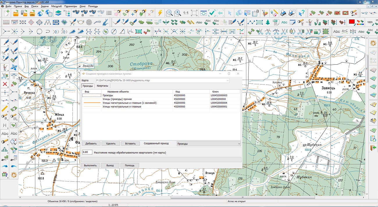
In the task, the mode has been improved, which creates additional passages on the map in the intervals between neighboring quarters and sides of streets. Quality of formation of passages has been improved. The unacceptable intersections of the created passage with map objects have been eliminated. The shape of passages located along quarters of complex shape has been improved. When creating a passage, the proximity of the passage's points to its source objects (quarter, side of the street) is checked. If the passage points are closer than the junction threshold, then the creation of the passage is not performed.
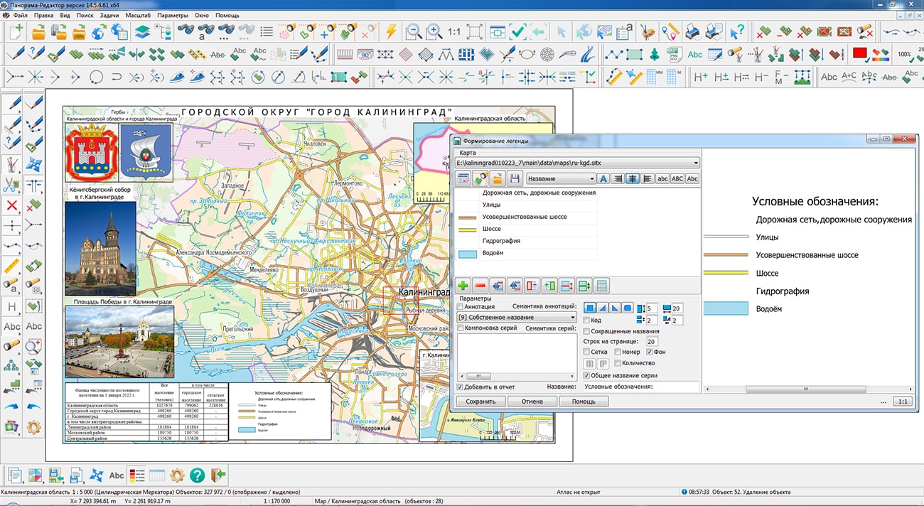
The task has been improved. In a mode "Legend Formation" the possibility has been added for automatic addition of the created legend onto a map of the report in the form of a map insert or an insert of the image depending on the chosen format of the saved legend.
The task has been improved. There is added a recording into the output file of the parameters of vertical coordinate system created in accordance with system of heights of an initial matrix. The name of the vertical coordinate system, units of measure of the heights containing in a file, and other parameters are stored in file GeoTIFF. For example: "Baltic 1977 height (EPSG:5705)", "MSL height (EPSG : 5714)", "WGS 84 (geographic 3D) (EPSG : 4327)".
The task has been improved. There is added the ability to import matrixes of heights or images from TIFF(GeoTIFF), IMG, KMZ files contained in the selected folder. When the element "Import heights from TIFF, IMG files" is enabled on the form, the control of the program is transferred to the dialog .
The module has been improved. New mode "Formation of forest declaration in electronic format (XML) with annexes" has been added. The form of the forest declaration, the procedure for filling out and submitting it, the requirements for the format of the forest declaration in electronic form were approved by the order of the Ministry of Natural Resources and Ecology of the Russian Federation dated April 29, 2021 N 303. Formation of the forest declaration is carried out for selected objects of the map - forest areas. The map is created using the forestry.v2 digital classifier. Entering information for filling the forest declaration form is performed by selecting values from the reference book and from the semantic characteristics of the selected objects. Reference information is stored in SQLite database tables.
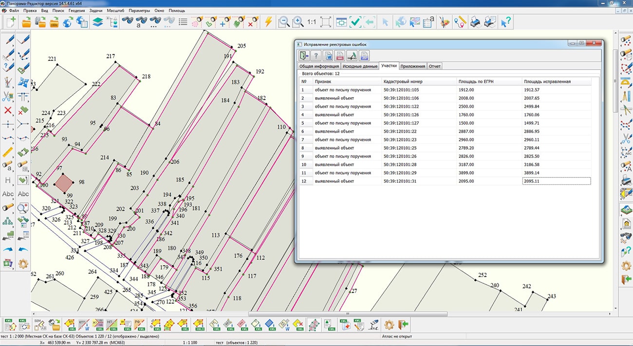
In the mode, there is corrected the order of reading information about the spatial component in the XML file. The "Correction of registry errors" mode has been refined based on feedback materials from representatives of the FCP. The order of formation of the text report has been changed and the templates have been updated. There is improved the module for saving into the XML document of the land survey plan version 9 of the ObjectsRealty element - Information about real estate objects located on the formed/modified land plot for recording additional elements the ApartHouse - Apartment building and PropertyComplex - Enterprise as a property complex (PIC).
The module has been improved. A new mode "Shortening the line (input distance)" has been developed. The mode provides cutting from a linear object at the beginning (or at the end) of a segment of a specified length. The mode has been updated. Calibration of a linear object based on data from a CSV file has been implemented.
The new version of the program is available for download in the Download section.


In KB "Panorama" the GIS "Panorama Mobile" version 1.1 has been developed for the Aurora OS. In the new version the possibility of opening the pyramids of tiles in Mbtiles format has been added, the interface of display of a map has been improved, display of current position on a map in the most common coordinate systems and various formats of representation has been implemented.
The Mbtiles format has been added into the list of formats supported by the application, designed to store a complete set of image layers of spatial data for the selected scale series. Using a set of tiles in a mobile application provides the display of spatial data containing a large number of objects or occupying large amounts of data in offline mode. The data can be prepared in advance for the required area in the or . To create pyramids of tiles, a combination of digital vector maps, space and aerial photography, elevation matrixes, data from geoportals (for example, Yandex or OpenStreetMap) can be used.
Possibility has been added for selecting the coordinate system and and format of representation for displaying the position on the map. Regardless of the type of used map, the user can set the most suitable display parameters from among the popular coordinate systems: SK-42, WGS-84 and PZ-90.11. Rectangular (meters) and geodetic (radians, degrees, degrees/minutes/seconds) units of measurement can be used as a format for representing coordinates. This possibility, together with the use of a geonavigation data receiver (GPS/GLONASS), allows you to get the current location in a more informative form. The received coordinates can be copied to the clipboard of the device and used for transmission or further processing.
GIS "Panorama Mobile" allows you to open the main formats of digital maps of GIS "Panorama" and popular geoportals on mobile devices based on the Aurora OS, to process information from the built-in GPS/GLONASS receiver. The user can prepare in advance a necessary set of spatial data in one of desktop products (GIS "Panorama", , ) and to transfer it into the mobile GIS "Panorama Mobile". The process of working with data is carried out autonomously, without connecting to the Internet. When the user moves, his current position is dynamically displayed according to the coordinates obtained from the GPS/GLONASS receiver. For ease of use, it is possible to synchronize the position of the map with the current location. To save the coordinates obtained during movement, a track recording mode is provided, which creates a separate map and puts the trajectory of movement onto it. For all objects of a map during the work the basic information is provided . The program is developed on the basis of the toolkit, which provides components for creating mobile applications for working with digital maps in the C++ programming language using the Qt.
- is a Russian mobile operating system developed by the "Open mobile platform" company. The operating system was created to build a trusted mobile infrastructure, protect sensitive information in government organizations, large and medium-sized commercial companies. Contributes to ensuring the technological sovereignty of the state through a secure mobile environment and meets all the requirements of regulators in the field of national security and information protection. Aurora OS allows centrally to operate the base of mobile devices and the used mobile software at use of Aurora Center. The current version of the Aurora mobile OS has been certified by the FSTEC of Russia and fully complies with the requirements for type "A" operating systems of 4 protection class and 4 trust levels.
The new version of the program is available for download in the Download section.

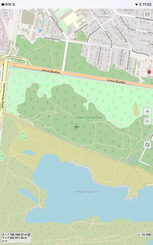

Specialists of KB "Panorama" prepared and placed the map of the Kirov region on the geoportal . The map was formed using OpenStreetMap data. To work with the map, you can use the program or other software products of KB "Panorama".
The map was led to the modernised classifier of large-scale plans of scale 1: 5 000 (map5000m) and was saved into a packed project (MPTZ). The MPTZ format project includes a digital map of the region's territory (country, subject of the federation, administrative region), a map of the administrative-territorial division of the region and a digital classifier. Publishing of updates in bank of spatial data is made by using the program of . Publishing contents of bank of spatial data on the geoportal and data access for downloading are implemented by means of .
Free maps on the basis of OpenStreetMap data are available for download on the page "Digital maps".


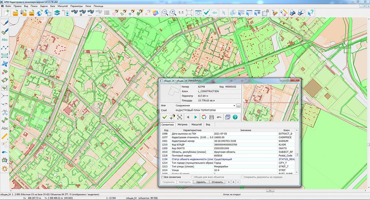
Specialists of KB "Panorama" have prepared a video lesson on the formation of an XML document and a paper report of the technical plan version 06 release 4 for putting an areal construction on cadastral registration. Users of "Workstation of cadastral engineer", or can form XML documents and paper reports of the technical plan by means of the .
The training material demonstrates the features of data preparation, filling in the mandatory characteristics and the formation of an XML file and a paper report of the technical plan version 06 in accordance with the Order of the Federal Service for State Registration, Cadastre and Cartography of March 15, 2022 No. P / 0082. On the basis of this order, in the software products of KB "Panorama" the classifiers of conventional symbols survey.v5.rscz and survey.v6.rscz were developed. The classifiers implement a common list of layers, semantic characteristics and objects for displaying cadastral information on cadastral maps and other cadastral documents.
The technical plan can be formed for one or several objects of real estate depending on a variant of a choice of objects on a cadastral map. The procedures "Formation of an XML document" and "Formation of a text report" are performed in the dialog. The initial initialization of the dialog content and the specifying the type of real estate object is performed by information from the digital cadastral map, taking into account the selected mode of formation.
Elements for input and editing of the data in dialog "Technical plan" are ordered on groups, according to sections and details of the technical plan, and arranged by screen (bookmarks): , , , , and .
You can get acquainted with the training materials in the "Video lessons" section.

Ph.: +7 (495) 739-0245, +7 (925) 221-1603
www.gisinfo.ru | panorama@gisinfo.ru
105005, Russia, Moscow, Baumanskaya Street 7, building 1, office 229 (m. Baumanskaya)
Copyright © Panorama Group 1991 - 2024


 Mobile version
 Full version