Copyright © Panorama Group 1991 - 2024

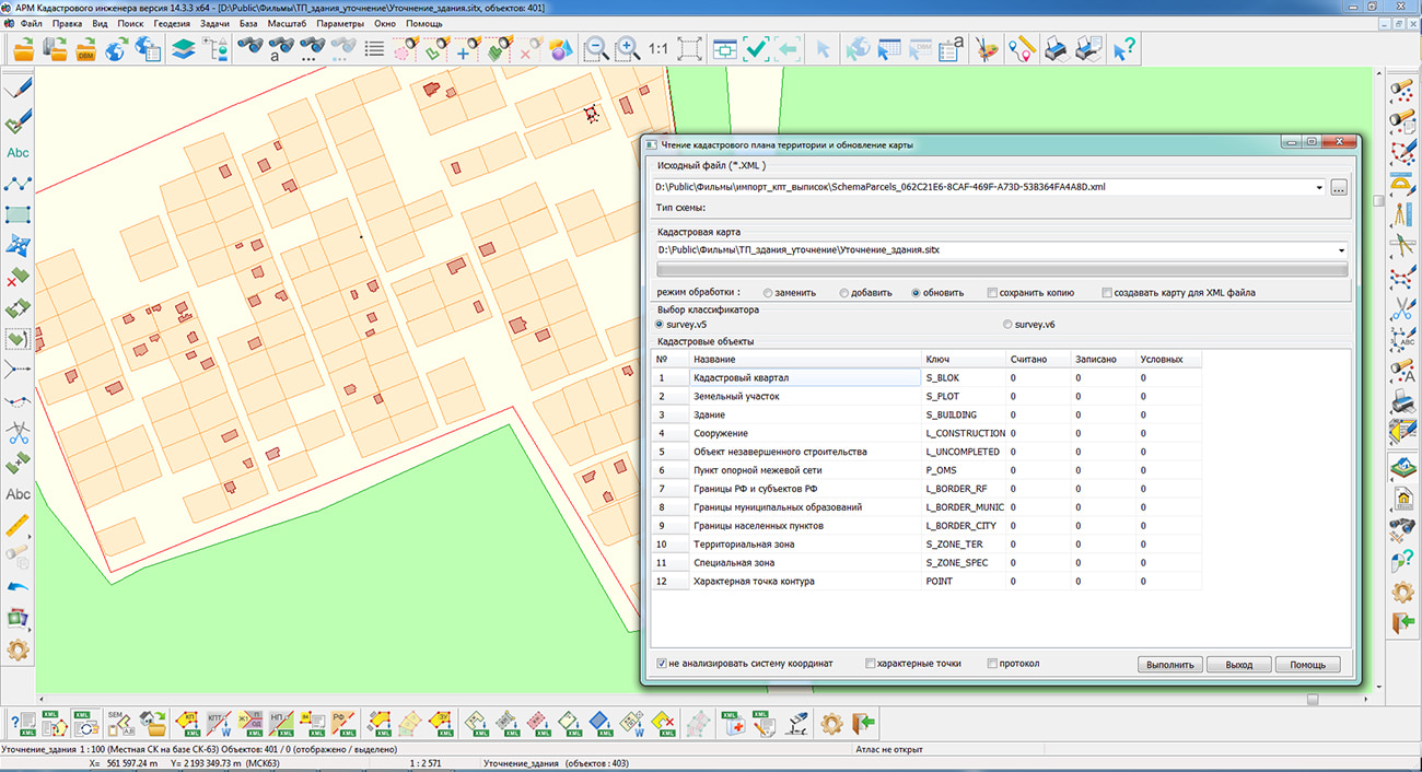
In KB "Panorama" the "Workstation of cadastral engineer" version 14.3.3 has been developed. In the new version, the modes "Reading of the cadastral plan of the territory and updating the map" and "Create objects from an XML file of the cadastre" have been improved. The ability to import information from XML files according to the SchemaParcels scheme has been added and the algorithm for creating multi-contour land plots and real estate objects has been corrected.
Work with layers of service the "Public cadastral map"of Rosreestr is optimised. When connecting the "Cadastral quarters" layer, data are requested from a more accurate level, taking into account the presence of tiles. On the layer "Cadastral plots" a possibility has been added for viewing information about plots by means of the button on the main panel the "Viewing the information on object".
Possibility of access to archival data of geoportals has been implemented. For example, to connect fire maps provided by the Information System for Remote Monitoring of Rosleskhoz. Access to information is carried out taking into account the specified time interval of observations.
For the mode "Land survey plan", the insertion and filling of section the "4. Information about the characteristics of the formed land plot" has been added when processing several selected objects. There is added a processing of repeated values for the cadastral numbers of the initial land plot, as well as the numbers of real estate objects located on the plot. The numbering of points in the section "1. Information about the characteristic points of the boundaries of the formed land plot" has been corrected. When forming an XML document when combining and redistributing land plots, in the absence of the value of the semantics "area according to the document", the area according to the map is inserted into XML. When forming the boundary plan, the following parameters were added: OGRNIP, TIN, number and date in the SRO register, the name of the Agreement. The templates for the form of the land survey plan have been updated in accordance with the Order of Rosreestr No. P/0592/ 0592. At formation of the Act of approval there is added a processing the table "3. Information about removal of objections concerning a location of boundaries:". In the table "1. Information about the results of matching the location of boundaries:" and in table 3, the filling of the document details from the semantics of the object is implemented.
For the text report of the technical plan, the date from the "Validity period" field has been added to the details of the verification certificate into the "Information on the used measuring instruments" section. Processing of multi-contour objects of real estate was corrected. There is added an insertion into the report of the cadastral number of another object of real estate, within which the processed object is located, of the type of permitted use of the object of real estate. Filling in information about the customer of cadastral work, which is a legal entity has been corrected. Templates of the form of the technical plan have been updated in accordance with Rosreestr Order No. P/0082.
For the "Map (plan) of object of land management" mode a recording and saving information about the representative's power of attorney has been corrected, and the ability to select from the "Base of cadastral works" information about the contract, cadastral engineer and customer has been added. When maintaining a catalog of coordinates, the "Coordinate system" field has been added to synchronize with information about the geodetic base for land survey and technical plans.
The new version of the program is available on the website in the Download section.


On August, 30-31, 2022 the together with the Federal State Budgetary Institution have held an international conference . The main goal of the conference is the exchange of experience and the development of promising directions of the development of monitoring the state of the subsoil, improving the methodology for monitoring endogenous and exogenous geological processes on the territory of the Russian Federation and neighboring states.
At the conference, the specialists of KB "Panorama" made the report . The participants of the event were shown the possibilities of the geoinformation platform "Panorama" for a collecting, processing and analyzing of spatial data coming from various sources. The report reflects the software technologies used in various monitoring systems for creation of digital maps, automatic updating the current situation, control of monitoring's indicators and formation of reports.
For geologists, hydrogeologists and surveyors, in addition to the Professional GIS "Panorama", special modules are installed that provide solutions to industry-specific problems. The program uses matrix models, methods of mathematical modeling, inclinometry calculations, linear coordinate systems, a profiling of a relief and geological layers. To maintain digital maps and plans in the field of geology, industry classifiers have been developed, including the necessary conventional symbols according to GOST and OST.
The results of measurements and observations on the monitoring's network are used to maintain a database of strong points of observation represented by wellhead coordinates or points of survey tours. Groundwater study points and of a relief are used to create a matrix of layers that characterizes the hydrogeological conditions of the area. are used to build various surfaces of geological, hydrological, hydrogeological conditions and evaluation factors or physical fields, including those based on hydrogeodeformational monitoring data.
Geoinformation platform "Panorama" provides the publication of digital maps, images, matrixes and object-oriented databases from a relational DBMS in the form of geoservices by means of . Layers of geoservices can be embedded in any GIS-application (desktop, web or mobile) by use of the developer tools. Development tools allow you to create interoperable GIS-applications that display digital maps by combining a hybrid of spatial data's layers from various network information resources.


In KB "Panorama" the for Qt Designer SE version 14.2.0 has been developed. In the new version a support of digital sea maps of the IHO S63 standard is implemented. An application system developer can add support for the standard into his application and register the application in the prescribed manner for obtaining a developer key (M_KEY). When calling a MAPAPI interface function from an application, a folder with data according to the S63 standard is specified, containing the PERMIT.TXT file, the developer key (M_KEY) and user permission (USERPERMIT). Data files of the sea map will be transformed into the project of maps (MPT) containing the list of SITX files encoded with the record's key from the user permission (hw_id6). More detailed information is given in the document "Programmer's guide". Testing of the S63 data access functions was performed using the test data of the S64 standard. Error messages in S63 data are written into the text log specified when calling the MAPAPI interface function.
Data exchange protocols with the have been optimized. Due to the optimization, the stability of the connection has been improved, process of addition of objects to data has been accelerated, and the amount of transmitted data has been reduced.
Support of the classifier of maps of agricultural purpose agro10t.rsc has been implemented. It is intended for creation of multilayered digital maps in agriculture and their applications in management of the agricultural enterprise. The classifier can be used to create map-schemes of agricultural land, maintain passports of fields, operational agrochemical monitoring of fields, thematic mapping for various categories and indicators, generate maps for managing transport and agricultural machinery of an enterprise, and solve transport logistics problems.
Conventional symbols have been added into the classifier of aeronautical maps to display the signatures of the minimum absolute flight altitude in the area with the value displayed in meters or feet. The symbols are designed in accordance with the requirements of Doc 8697 ICAO Guidelines for Aeronautical Charts. The S57navy digital classifier of sea maps and the procedure for importing digital maps of the S57 standard have been improved to increase the degree of compliance of the displayed maps with the S52 standard.
GIS Constructor is a set of geoinformation components for use in the visual programming environment of Qt Designer, which allows you to develop your own GIS applications. The visualization of the contents of digital maps is made in conventional symbols adopted for topographic, geographical and various special maps. Geoinformation system has ample opportunities for performing calculations, for providing display of spatial data on various graphic devices in standard and user systems of conventional symbols. The main functions can be executed in multithreaded mode. It supports automatic optimization of used memory for processing large amounts of data (tens of gigabytes) on limited resources (hundreds of megabytes).
The toolkit is adapted for work on a wide range of operating systems (Astra Linux SE, ALT Linux, Elbrus, Ubuntu, CentOS, QNX) and architectures (Intel, Elbrus, PowerPC, SPARC, ARM). The toolkit includes components of visual designing the GIS applications and library of a multiplatform multithreaded GIS core. GIS Constructor provides a cross-platform MAPAPI interface that allows a programmer to implement development in an operating system convenient for it. The developer can release GIS applications for a set of operating systems by simple assembly with minimal changes to the program source code.
The new version of the program is available for download in the section.


Specialists of KB "Panorama" have updated a video lesson on export of data of territorial planning into GML format for the subsequent transfer onto the FSIS TP portal. Users of the and can generate documents for territorial planning of municipalities using the task from the "Run applications" complex, users of "Workstation of urban-planner" can form documents by means of the complex of urban-planning tasks.
The training material demonstrates the features of data preparation, filling in mandatory characteristics and generating GML files in accordance with the Order of the Ministry of Economic Development of the Russian Federation dated January 9, 2018 No. 10. On the basis of this order in software products of KB "Panorama" the classifier of conventional symbols terrplan.v5.rscz has been developed. The classifier implements a general list of layers, objects and attributive characteristics of objects of territorial planning and urban planning.
The task "Export territorial planned data in GML" provides reading of map objects and uploading them into a GML file. Maps of documents of territorial planning are made in accordance with the level of management: territorial planning schemes of the Russian Federation, territorial planning scheme of a subject of the Russian Federation, territorial planning scheme of a municipal district, master plan of an urban district and master plan of an urban settlement.
You can get acquainted with the training materials in the "Video lessons" section.


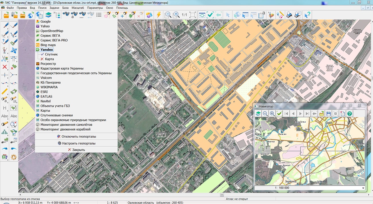
Specialists of KB "Panorama" have prepared and placed the maps of the Lipetsk and Oryol regions on the geoportal . The maps were formed using OpenStreetMap data, source data were obtained from website. To work with the maps, you can use the program or other software products of KB "Panorama".
The maps were led to the modernised classifier of large-scale plans of scale 1: 5 000 (map5000m) and were saved into a packed project (mptz). Publishing of updates in bank of spatial data is made by using the program of . Publishing contents of bank of spatial data on the geoportal and data access for downloading are implemented by means of .
Free maps on the basis of OpenStreetMap data are available for download on the page "Digital maps".


Ph.: +7 (495) 739-0245, +7 (925) 221-1603
www.gisinfo.ru | panorama@gisinfo.ru
105005, Russia, Moscow, Baumanskaya Street 7, building 1, office 229 (m. Baumanskaya)
Copyright © Panorama Group 1991 - 2024


 Mobile version
 Full version