Copyright © Panorama Group 1991 - 2024

Specialists of KB "Panorama" have tested for compatibility of the software the, , with OSON "OSnova". During tests, there were confirmed the compatibility and correctness of working the software the GIS Operator SE, GIS "Panorama", GIS "Panorama Mini" and OSON "OSnova".
GIS Operator SE - universal domestic geoinformation system for power structures. The program is designed for accumulation, storage, the automated processing and display of data, calculation results and forecasts with geospatial reference. GIS Operator SE contains tools of displaying and processing vector, raster and matrix maps. The application provides users with tools for solving specialized tasks of modeling the movement of special objects against the background of 3D model, forecasting of consequences of emergencies at hazardous objects, monitoring of aircraft movement, conducting of geodetic and topographic work, processing the data from GPS/GLONASS navigation devices, printing the displayed spatial data to various output devices and many others.
GIS Operator SE is certified according to the 2nd level of control of the absence of undeclared capabilities in the Ministry of Defense of the Russian Federation, it is included in the Unified register of Russian programs for electronic computers and databases (registry entry No.10628 of 05/27/2021).
GIS "Panorama" is the universal geographic information system that has tools for creating and editing digital maps and city plans, processing remote sensing data, performing various measurements and calculations, overlay operations, building 3D models, processing raster data, tools of preparing graphic documents in digital and printed form, as well as tools for working with databases. GIS is used for mapping, land management and cadastre, geodetic surveys, and the creation of geoportals. The GIS is included in the Unified register of Russian programs for electronic computers and databases (registry entry No.4227 dated March 29, 2018).
GIS "Panorama Mini" is the universal geoinformation system designed to collect spatial data, maintain a database of spatial data, create and update digital maps and plans, and create information systems for various purposes. The GIS is included in the Unified register of Russian programs for electronic computers and databases (registry entry No.7226 dated 11/03/2020).
OSON "OSnova" is a general-purpose Operating system designed to build secure automated systems that process confidential information and personal data. Developer JSC "NPPKT". OSON "OSnova": Certificate of state registration of the computer program No. 2018616118 dated 05/23/2018. It is included in the Unified register of Russian programs for electronic computers and databases (registry entry No. 5913 dated November 19, 2019). Certificate of Conformity of the FSTEC of Russia No. 4381 for compliance with the information security requirements established in the documents "Information security requirements that establish levels of trust in technical information security tools and information technology security tools" (FSTEC of Russia, 2020) - for the 4th level of trust, "Information security requirements for operating systems" (FSTEC of Russia, 2016), "Profile of protection of operating systems type A of the fourth protection class IT.OS.A4.PZ" (FSTEC of Russia, 2017).


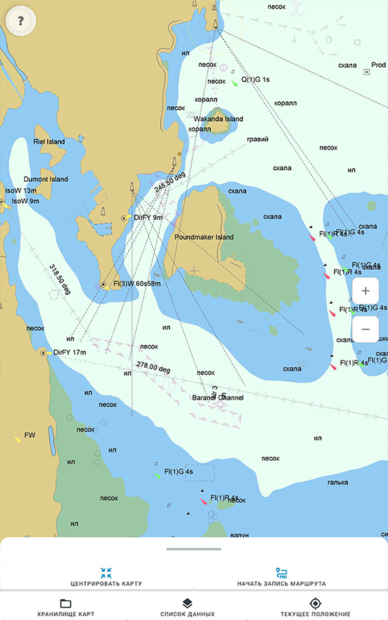
In KB "Panorama" the has been developed for Android OS. The program allows you to open the main formats of digital maps of the on Android-based mobile devices and process the information from the built-in GPS/GLONASS receiver. The user can prepare in advance a necessary set of the spatial data in one of desktop products (, , ), pack them into archive of ZIP format by standard tools and to transfer into mobile GIS "MapView". The process of working with data is carried out offline, without connecting to the Internet. When the user moves, his current position is dynamically displayed according to the coordinates received from the GPS/GLONASS receiver. For ease of use, it is possible to synchronize the position of the map with the current location. To save the coordinates obtained during the movement, a track recording mode is provided, which creates a separate map and puts the trajectory of movement onto it. For all objects of a map during the work the basic information is provided.
Users can jointly display vector maps (topographic, operational situation, marine navigation, aeronautical), matrix and raster data (Earth remote sensing data). Modern packed formats of vector maps SITZ, MAPZ, MPTZ are supported, which are decompressed in RAM on the fly. The program has been developed on the basis of toolkit the GIS Constructor for Android, which provides components for creation of mobile applications for work with digital maps in the Kotlin programming language.
The source code of the GIS "MapView" for Android OS is included in the software product the GIS Constructor for Android and can be taken as a basis for creating your own mobile application in the programming language. GIS "MapView" uses the MAPAPI programming interface, which implements ample opportunities for performing calculations, providing display of spatial data in standard and user systems of conventional symbols. The MAPAPI programming interface is accessed via the Java Native Interface (JNI) programming interface. The JNI programming interface allows accessing MAPAPI libraries implemented in C/C++ from the Java/Kotlin language. An example of the implementation of this interface is included into composition of GIS Constructor for Android.
The cross-platform nature of the MAPAPI interface allows the programmer to develop and test GIS applications on a desktop operating system using the GIS Constructor available for a set of Linux systems. After debugging on the desktop system, a developer can build an Android application with minimal changes to the source code of the program.
GIS Constructor for Qt Designer SE and GIS "MapView for Android OS" are available for download in the section.


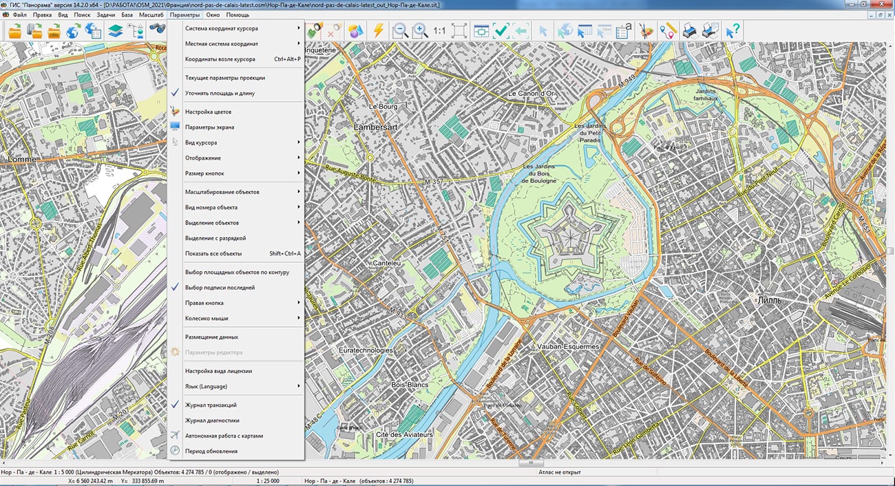
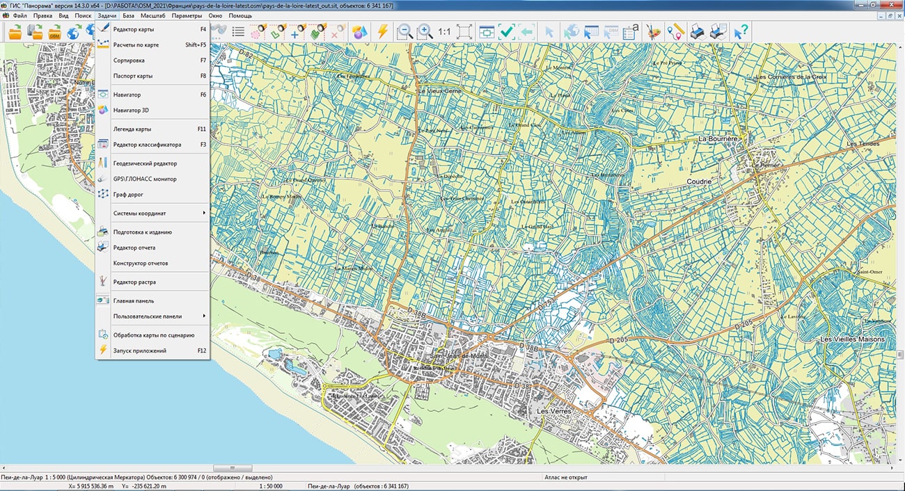
Geoportal has been supplemented with maps of the regions of France the Upper Normandy, Nord-Pas-de-Calais and Pays-de-la-Loire formed according to OpenStreetMap data. Source data was obtained from website. To work with the maps, you can use the program or other software products of KB "Panorama".
The maps were led to the modernised classifier of large-scale plans of scale 1: 5 000 (map5000m). Publishing of updates in bank of spatial data is made by using the program of . Publishing contents of bank of spatial data on the geoportal and data access for downloading are implemented by means of .
Free maps on the basis of OpenStreetMap data are available for download on the page "Digital maps".


In KB "Panorama" the version 14.2.0 has been developed for creating GIS applications. The new version includes an API in the Python language that allows using the 64-bit GIS-core to access spatial data in exclusive and multi-user modes.
Python is an actively developing scripting language that is used to solve a large number of the most diverse problems and tasks. For functioning API in Python language the installed Python 3.7 х64 is required.
The new version includes an example in a Python language which is the desktop application developed with use of the Tkinter GUI framework. The example provides: opening a map, displaying and moving the map image in the application window, searching for map objects at the mouse click point, displaying detailed information about the selected map object in the form of a standard dialog from the GIS-core, calculating the statistics for all available map objects.
The GIS ToolKit consists of a set of visual components (supplied in source code) and API functions of the GIS core for direct access to spatial data. The toolkit is designed to develop client-server and desktop 32-bit and 64-bit applications that require processing and visualization of spatial data. Spatial data can be located both at the workplace (direct access to data), and in a local network or the Internet (access components to the or data exchange using international protocols are used).
The new version of the program is available for download on the Download page.


In KB "Panorama" the version 14.5.2 has been developed. The new version adds the ability to publish in local coordinate systems the information from general and urban plans, technical projects of industrial and mining enterprises, plans for seaports and shipyards, communication plans and other data. Service allows to display, perform search, to make calculations and to edit the information contained in in the published data.
In the new version a support of any user and local coordinate systems has been added. All calculations and work with data in the service is performed in the projections installed in these systems. This improves the accuracy of all calculations when working with geospatial data.
Requests of building a legend have been improved. Support of the point objects created at thematic mapping is added. The request of copying objects has been refined. Possibility of use of arbitrary filters at copying is implemented. The output of information about errors has been expanded when answering the user.
GIS WebService SE supports all international standards (OGC WFS, WFS-T, WMS, WMTS, WCS), which are used to transfer and display spatial data. The program implements the ability to issue tiles according to any user or local coordinate system. The application is implemented on Windows and Linux platforms and is compatible with Apache, IIS and nginx web servers.
The new version of the program and documentation are posted on the website in the section.


Ph.: +7 (495) 739-0245, +7 (925) 221-1603
www.gisinfo.ru | panorama@gisinfo.ru
105005, Russia, Moscow, Baumanskaya Street 7, building 1, office 229 (m. Baumanskaya)
Copyright © Panorama Group 1991 - 2024


 Mobile version
 Full version