Copyright © Panorama Group 1991 - 2024

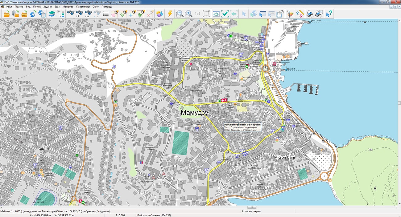
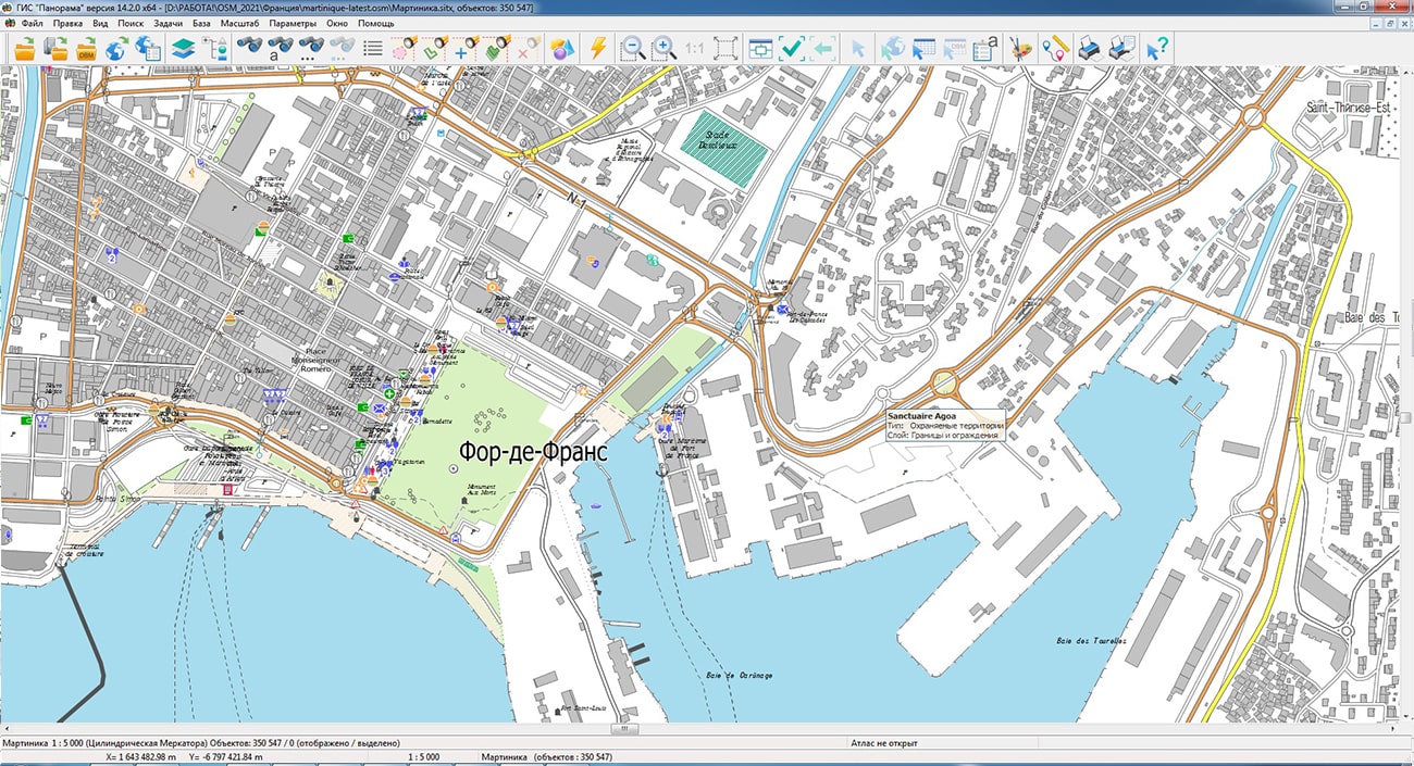
Geoportal has been supplemented with maps of the regions of Martinique and Mayotte (France), formed according to OpenStreetMap data. Source data was obtained from website. To work with the maps, you can use the program or other software products of KB "Panorama".
The maps were led to the modernised classifier of large-scale plans of scale 1: 5 000 (map5000m). Publishing of updates in bank of spatial data is made by using the program of . Publishing contents of bank of spatial data on the geoportal and data access for downloading are implemented by means of .
Free maps on the basis of OpenStreetMap data are available for download on the page "Digital maps".


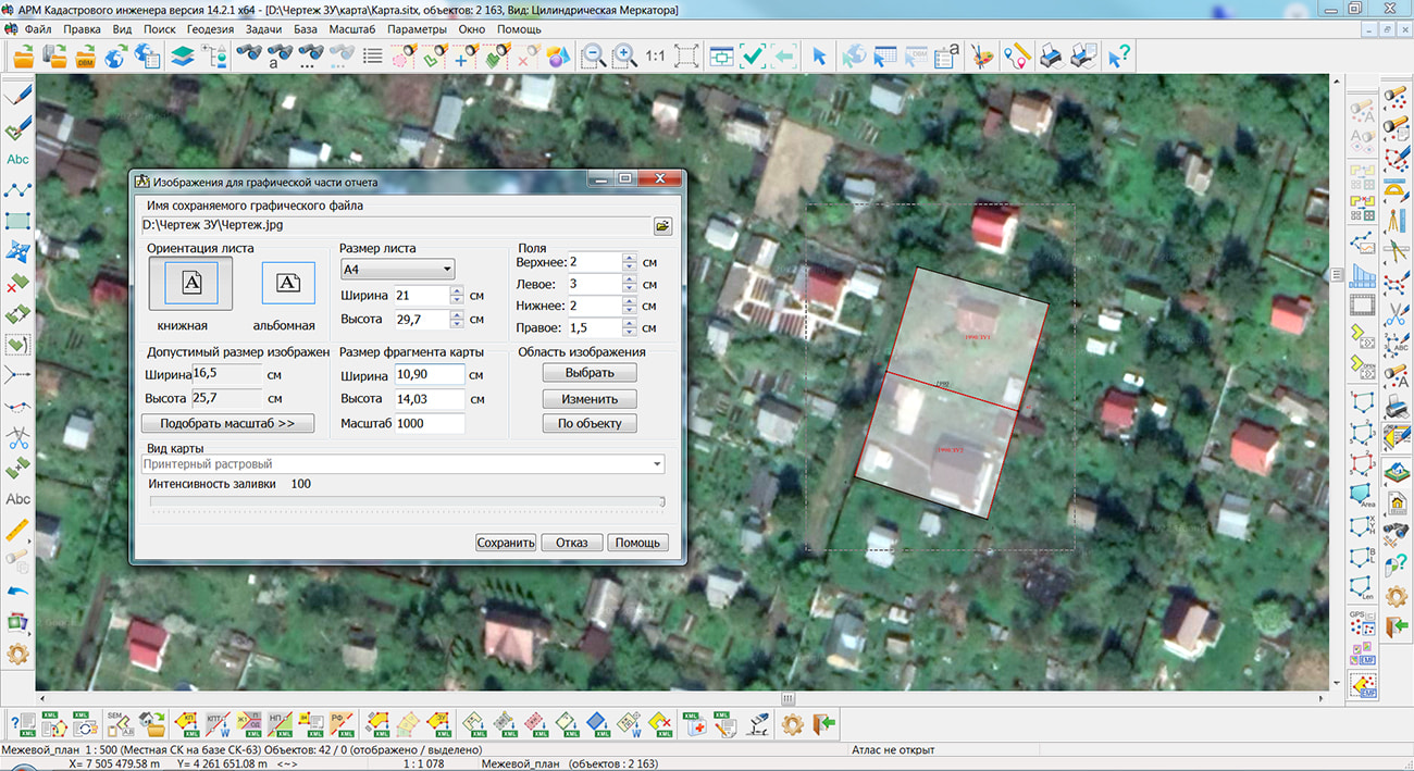
Specialists of KB "Panorama" have prepared a video lesson on the formation of a graphic file of a drawing of land plots and their parts. Users of the "Workstation of cadastral engineer", or can draw up drawings of land plots with the subsequent formation of graphic files of drawings using the tools of the complex of geodesy calculations.
The training material demonstrates the procedure for the formation of a drawing of land plots and their parts, drawn up in accordance with the Order of the Ministry of Economic Development of the Russian Federation from December, 8th, 2015 № 921. On the basis of this order in software products of KB "Panorama" the classifiers of conventional symbols survey.v5.rscz and survey.v6.rscz have been developed. In the classifiers there are implemented a general list of layers, semantic characteristics and objects for display of cadastral data on cadastral maps and other cadastral documents. Preparation of a drawing of land plots and their parts is an obligatory stage in the production of cadastral works on the formation of a land survey plan of the plot.
You can get acquainted with the training materials in the "Video lessons" section.


In KB "Panorama" the version 6.5.0 has been developed for operating systems Astra Linux, CentOS, Ubuntu, MS Windows. The "Cartogram" component has been updated in the new version. The component provides a way of display in the form of a thematic map of socio-economic indicators or phenomena of displayed objects and the features of their distribution over the territory, displays the dynamics of changes of indicators in time and space. Quantitative indicators for spatial objects are loaded from a file of the tabular data of CSV format or from any text file. The constructed thematic maps can be used for analysis of various indicators in healthcare, geology, marketing and other areas. The example of a CSV-file for creating a cartogram is available on our site.
In "Search by map" a possibility of determining the address of a point by its coordinates has been added. For example, you can specify a point near a house on a map and get its address. The search result is displayed as a list in the "Map Objects" panel. Data acquisition is carried out through HTTP API of reverse geocoding of the address search source.
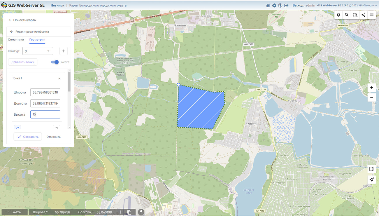
Possibility of editing the geometry of object in a tabular kind is added. Change of the metrics of object is visually displayed on a map, the information on object editing is recorded into the map's event log.
For dynamically updated map layers, the ability to track the state of these layers on the server has been added. Obtaining an image of dynamically updated layers (for example, when monitoring vehicle traffic) is performed if the state of data on the server has changed. It allows to optimise the number of data requests to the server. For work it is necessary to use a service the version 14.4.1 and higher.
In the new version the toolkit for developing Web applications the GIS WebToolKit SE has been improved, which expands the capabilities of GIS WebServer SE and can be integrated into other information systems. Access to data (images, vector maps and information about the terrain) is provided by Web services according to the generally accepted OGC protocols and ISO standards. Various types of elevation data are used as a digital elevation model: matrixes (in SRTM, GeoTIFF, IMG, MTW formats), TIN models, point clouds, and others.
can be as a source of spatial data. It provides collection, storage, search and issuance of spatial data in exchange formats, a displaying the state of the data bank in the form of maps-schemes, automated generation and updating of geo-covers.
GIS WebServer SE is used in the construction of closed corporate systems to ensure the protection of data having a security classification or a trade secret. GIS WebServer SE complies with the information security requirements on the 2nd level of control over the absence of undeclared capabilities. The new version of the program expands the possibilities of the application when solving problems of analysis, management and long-term planning of the development of territories. GIS WebServer SE is implemented using the GIS WebToolKit SE, which can be used in development tools that use the JavaScript.
The new version of the program is available on the website in the section.


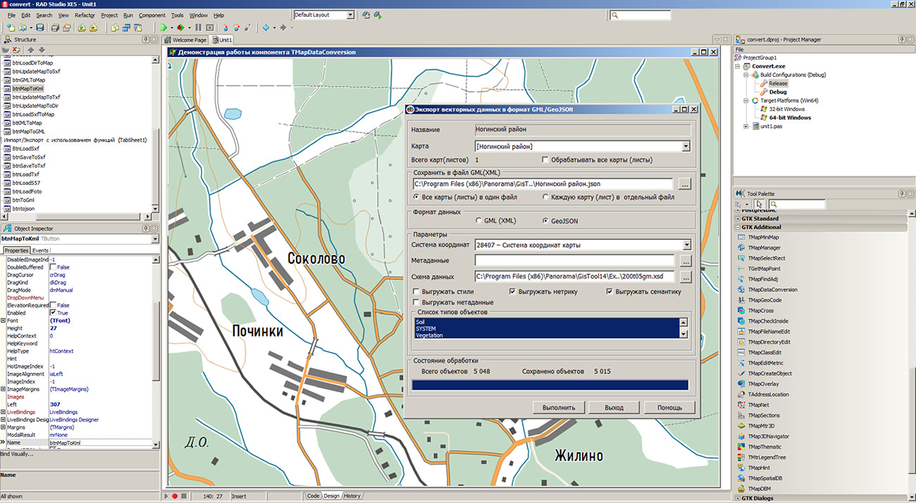
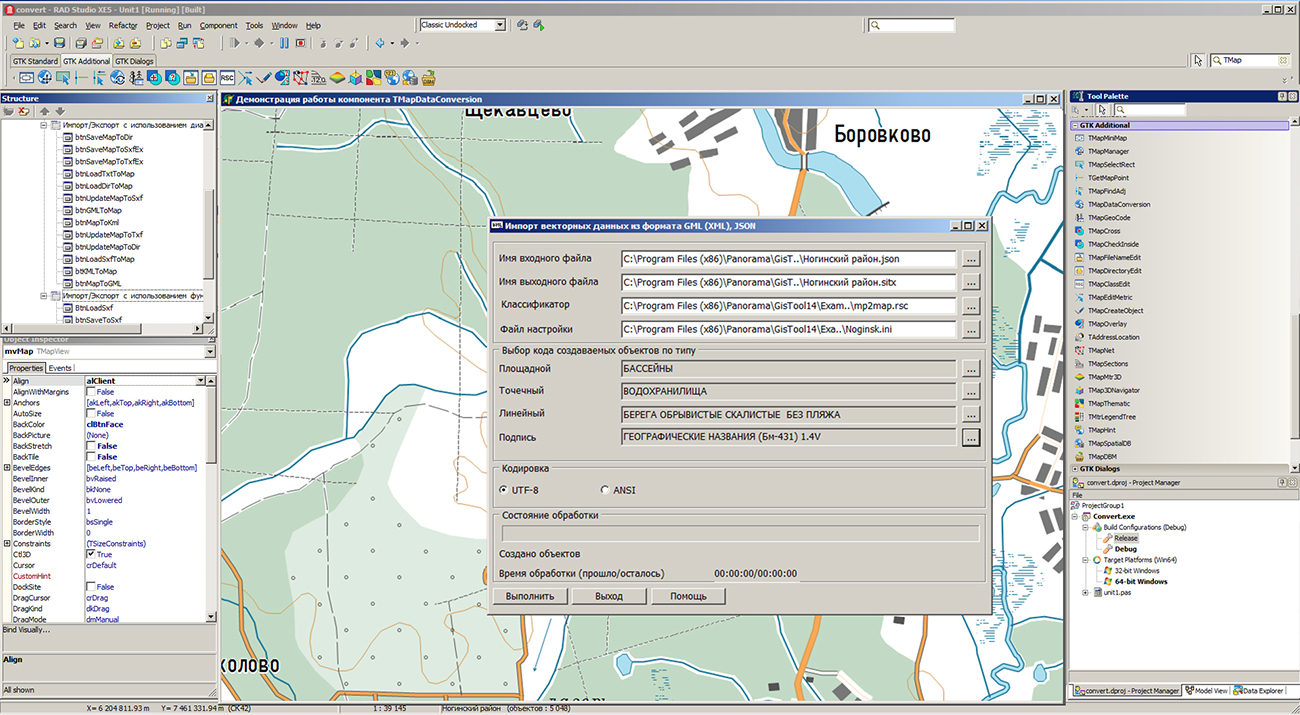
In KB "Panorama" the version 14.1.0 has been developed for creating GIS applications in the environment of C++ Builder, Delphi Embarcadero. In the new version the TMapDataConversion component has been improved. It provides conversion of spatial data presented in formats SXF, TXF, DIR, TXT, MAP, SIT, SITX, S57, KML/KMZ, MIF/MID, GML, GeoJSON. The component is based on the use of high-performance functions of the GIS core.
Into TMapDataConversion component the new functions have been added, allowing to carry out converting of spatial data into formats GML, GeoJSON, KML in a streaming mode or with use of dialogs. Export's settings are available to users: data format, coordinate system, mode for creating styles of conventional symbols, composition of metric, semantics and metadata, processing of a set of maps.
When processing data, the TMapDataConversion component receives information about the current state of the process: the percentage of execution, the presence of errors, the need to interrupt processing, information about the current map.
In the new version, the tools for searching for map objects in the TMapFind component have been expanded. The component now has the ability to search for objects based on their visibility in the current map display scale.
In the dialog of the TMapObj component, the ability has been implemented for adding and editing semantics of type the "Link to the file folder". Value of semantics is the name of directory, which contains many files of different formats and folders. When accessing the filled semantics "Link to the file folder", a list of files contained in the root folder and subfolders is automatically generated. By double click by a mouse on the chosen file, the corresponding program of recognizing and processing the file is started. When referring to documents, tables and graphic images, the contents of the file are displayed, when referring to spatial data, the dataset is opened in a separate window. The folder with documents can be compressed into a ZIP file, and the object can be assigned the semantics of the "Link to a file" type. Actions with documents will be the same as when linking to a folder. When packing maps into MAPZ, SITZ, MPTZ formats, documents referenced from the semantics of type the "Link to the file folder" will also be packed into one data set, unlike semantics the "Link to a file".
In the "Select Object" dialog on the bookmark, the "Display order" item has been added into the context menu intended for selecting the property "Above everyone", "Below all", "Normal", which affects the position of an object relative to other objects. When the "Normal" property is set, the display order of the object is determined in the classifier by its layer, type of conventional symbol and localization. Into the context menu the "Save metric coordinates to EPSG:3857" item has been added, intended for saving the object metric in GeoJson format in the Mercator projection on the WGS-84 sphere.
To display tables with data on the map, a new graphic symbol has been developed. This symbol is a point object that has a link to a CSV file in semantics and a conventional symbol of the table type. The graphic parameters of the table are customized in the semantics of the object, in the RSC classifier or in the graphic parameters of the object. The table cell allows to place the text, the numerical data, pictures (in PNG, JPG, BMP format), colored figures and the percentage scales. The table can consist of one or more pages. Table parameters are customized in the dialog. A layer with tables can be opened on top of any other data - spatial databases, geoportals, remote sensing data. The map, together with CSV files and background data, can be packed into one file of SITZ/MAPZ/MPTZ formats.
The GIS ToolKit consists of a set of visual components (supplied in source code) and API functions of the GIS core for direct access to spatial data. The toolkit is intended for the development of client-server and desktop 32-bit and 64-bit applications that require processing and visualization of spatial data. Spatial data can be located both at the workplace (direct access to data) and in a local network or the Internet (components of access to the or data exchange by international protocols are used).
The new version of the program is available for download on the page.

Specialists of KB "Panorama" prepared and placed the map of the Republic of India on the geoportal . The map was formed using OpenStreetMap data, source data was obtained from website. To work with the map, you can use the program or other software products of KB "Panorama".
The map was led to the modernised classifier of large-scale plans of scale 1: 5 000 (map5000m). Publishing of updates in bank of spatial data is made by using the program of . Publishing contents of bank of spatial data on the geoportal and data access for downloading are implemented by means of .
Free maps on the basis of OpenStreetMap data are available for download on the page "Digital maps".


Ph.: +7 (495) 739-0245, +7 (925) 221-1603
www.gisinfo.ru | panorama@gisinfo.ru
105005, Russia, Moscow, Baumanskaya Street 7, building 1, office 229 (m. Baumanskaya)
Copyright © Panorama Group 1991 - 2024


 Mobile version
 Full version