Copyright © Panorama Group 1991 - 2024

In KB "Panorama" the version 11.0.0 has been developed. The new version adds monitoring of spatial data with the ability to partially update tiles by changed data. Imagery Creator includes all possibilities of product the Imagery Service. The program starts automatically at the start of the operating system and works as the Imagery Creator service. It can function round the clock unlimited time and perform the tile update process at a specified time.
Pyramids of tiles are created on the basis of a combination of digital vector maps, space and aerial photography, matrixes of elevations, data from geoportals and other spatial data. To read the source geodata, the program can connect to the GIS Server or open datasets in the local network. The program performs monitoring of data changes in the transaction log for vector data, by time of updating of the raster and matrix data, and automatically updates those tiles on which changes have occurred.
The list of supported formats has been expanded. Ability was added to cut data for files MPT, MPTZ, MAPZ, SITZ, DBM. The program allows you to cut tiles for geospatial databases controlled by PostgreSQL, MS SQL and Oracle DBMS, in accordance with the OGC 06-103r4 standard: "OpenGIS Implementation Standard for Geographic information - Simple feature access - Part 1: Common architecture". Communication with the database is based on a pre-configured DBM file (project) created in the service administrator. The DBM file contains a description of the parameters of a digital vector map, in the form of which a data set from the database will be displayed (table, view, or the result of an SQL query). The parameters include: the conventional name of the map; RSC classifier file containing a library of conventional symbols; coordinate system code (standard EPSG code or user's code from the crslist.xml file); the scale of the map, in which the conventional symbols are displayed in a unit scale (in those sizes that are specified in the classifier).
The program allows you to create tiles in the formats JPEG, PNG, PNG8, Mbtiles, BIR and GeoPackage according to the international standard OGC WMTS 07-057r7 version 1.0.0, the TMS standard and OGC 12-128r15 GeoPackage version 1.2.1. Tile data formed by Imagery Creator is used by the , software products to ensure high speed of execution of queries on displaying the spatial data over vast territories with the simultaneous access of a large number of users.
The new version of the program is available on the page.


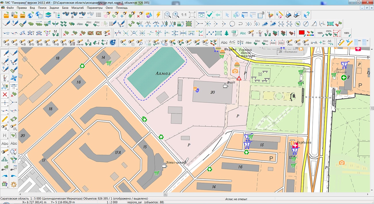
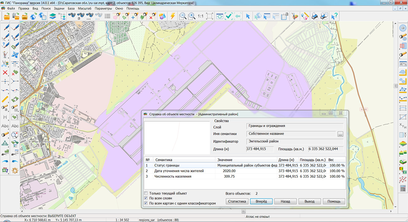
Specialists of KB "Panorama" prepared and placed the map of the Saratov region on the geoportal . The map was formed using OpenStreetMap data, source data was obtained from website. To work with the map, you can use the program or other software products of KB "Panorama".
The map was led to the modernised classifier of large-scale plans of scale 1: 5 000 (map5000m) and was saved into a packed project (MPTZ). The MPTZ format project includes a digital map of the region's territory (country, subject of the federation, administrative region), a map of the administrative-territorial division of the region and a digital classifier. Publishing of updates in bank of spatial data is made by using the program of . Publishing contents of bank of spatial data on the geoportal and data access for downloading are implemented by means of .
Free maps on the basis of OpenStreetMap data are available for download on the page "Digital maps".


JSC KB "Panorama" and have confirmed the compatibility and correctness of the work of geoinformation system the GIS "Panorama" with the RED OS operating system.
Geographic information system is the universal geographic information system that has tools for creating and editing digital maps and city plans, processing remote sensing data, performing various measurements and calculations, overlay operations, building 3D models, processing raster data, tools of preparing graphic documents in digital and printed form, as well as tools for working with databases. Geographic information system GIS "Panorama" is registered in the Unified Register of Russian Computer Programs and Databases (№4227).
is a Russian operating system of the Linux family for servers and workstations, providing a universal environment for using application software. The product is certified by the FSTEC of Russia (№ 4060 dated 01/12/2019), which confirms its compliance with information security requirements and allows its use in state information systems. RED OS is registered in the Unified Register of Russian Computer Programs and Databases (№ 3751).
"RED SOFT develops the RED OS ecosystem, complementing it with products of various purposes. With the help of the GIS Panorama, for example, you can create and edit digital maps and city plans. Thanks to the joint work with partners, RED OS becomes an universal environment, allowing customers from various industries to use the specialized software on the Russian operating system ", - commented Rustam Rustamov, Deputy General Director of RED SOFT.


In KB "Panorama" the new versions of server software products the , , have been developed for the domestic operating system Astra Linux SE used on servers with processor architecture "Elbrus". These programs are part of the complex of maintaining the regional geoportal . The complex is intended for maintaining a bank of spatial data, publication of the digital cartographic information, data of the Earth's remote sensing (ERS), thematic information from databases, documents, navigation information, organizing remote interaction with automated control systems, systems for monitoring the terrain state, transport management, ensuring urban planning tasks, maintaining a cadastre of land and real estate, and others. of KB "Panorama" are used at creation of web portals of various level: Federal, regional, municipal, corporate or sectoral.
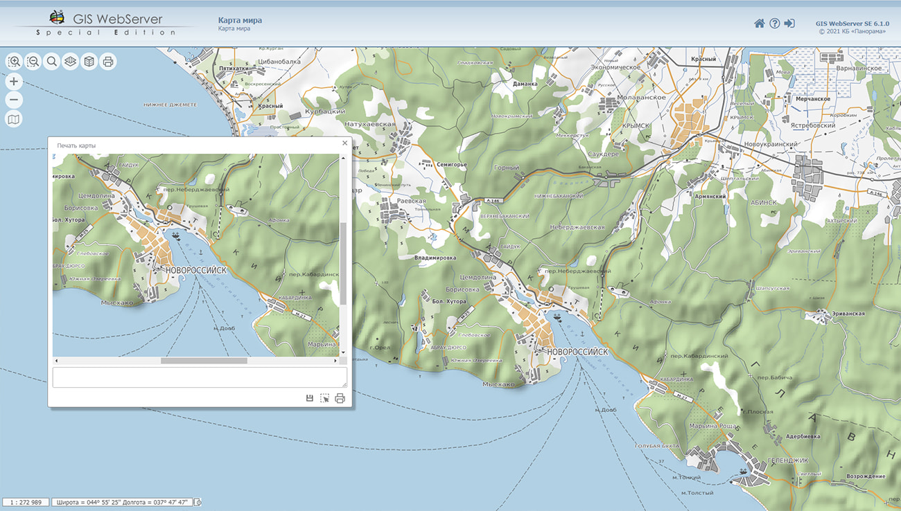
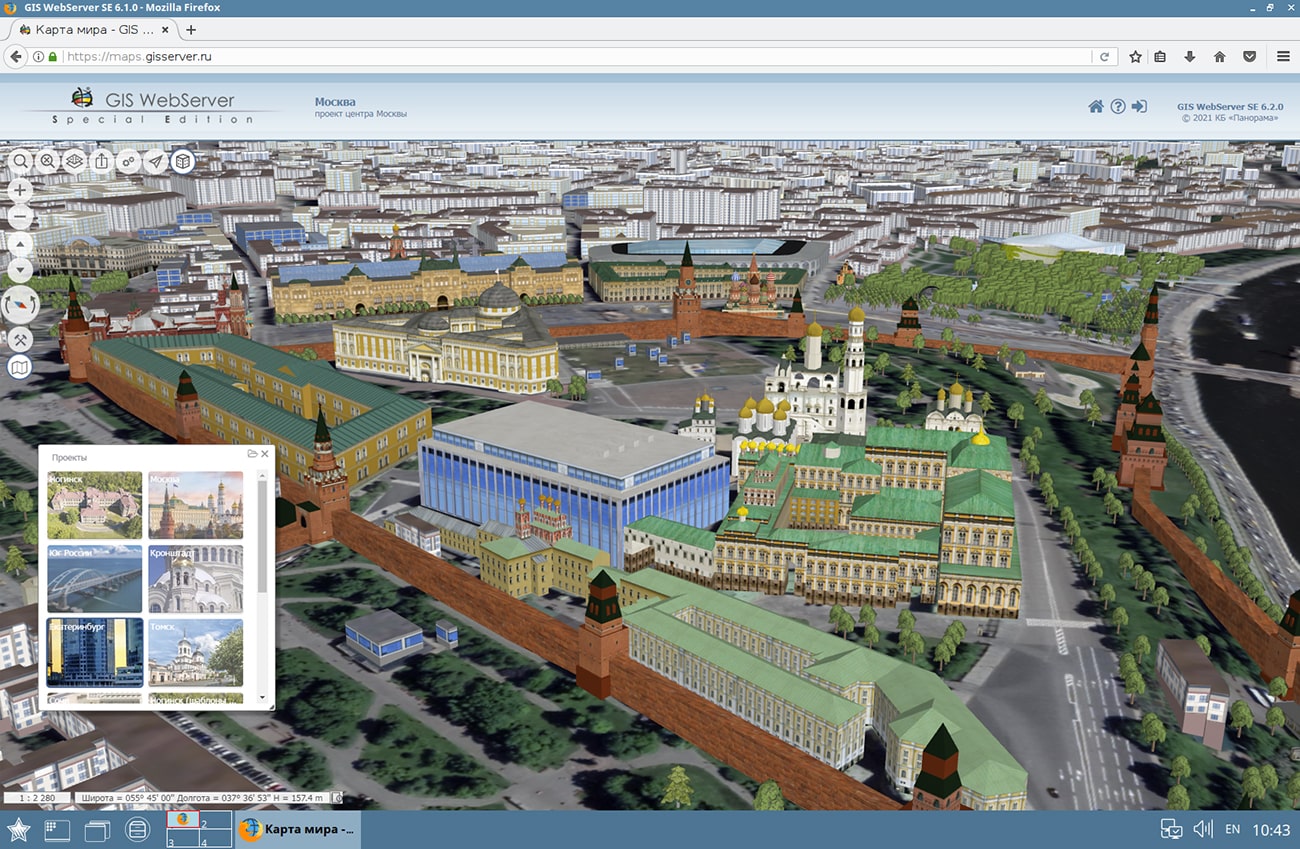
Cartographical service the is used as a source of spatial data. Data exchange with GIS WebService SE service is performed according to the OGC (Open Geospatial Consortium) specification. The program implements the ability to issue tiles for any user or local coordinate system. The application is compatible with Apache, IIS and nginx web servers.
allows you to create tiles in international formats. Tile data generated by Imagery Creator is used by the software products the , GIS WebService SE to ensure high speed of execution of requests for displaying spatial data over vast territories with simultaneous access of a large number of users.
is intended to provide remote access to vector maps, remote sensing data, matrixes, documents and spatial databases of users of programs the GIS "Panorama", GIS "Operator", GIS WebService SE and others. Users of desktop and web applications on different platforms can simultaneously view and edit data in accordance with access rights.
On the basis of the server software products of KB "Panorama", demo thematic web projects have been deployed: , , , and others. You can get acquainted with the work of geoportals on the website .
New versions of server software products are available for download on the page.


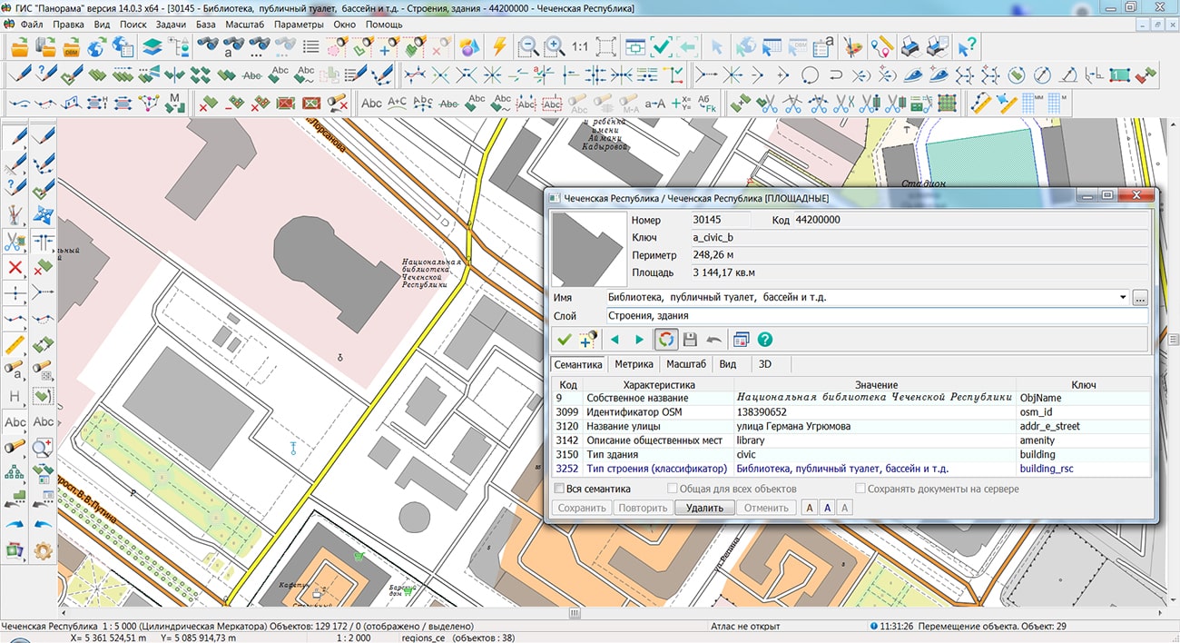
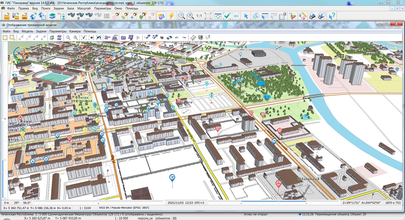
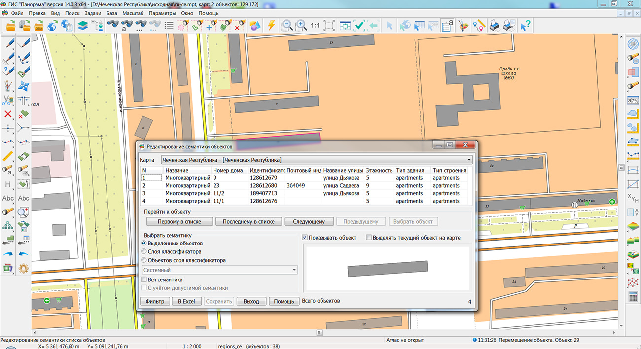
Specialists of KB "Panorama" prepared and placed the map of the Chechen Republic on the geoportal . The map was formed using OpenStreetMap data, source data was obtained from website. To work with the map, you can use the program or other software products of KB "Panorama".
The map was led to the modernised classifier of large-scale plans of scale 1: 5 000 (map5000m) and was saved into a packed project (MPTZ). The MPTZ format project includes a digital map of the region's territory (country, subject of the federation, administrative region), a map of the administrative-territorial division of the region and a digital classifier. Publishing of updates in bank of spatial data is made by using the program of . Publishing contents of bank of spatial data on the geoportal and data access for downloading are implemented by means of .
Free maps on the basis of OpenStreetMap data are available for download on the page "Digital maps".


Ph.: +7 (495) 739-0245, +7 (925) 221-1603
www.gisinfo.ru | panorama@gisinfo.ru
105005, Russia, Moscow, Baumanskaya Street 7, building 1, office 229 (m. Baumanskaya)
Copyright © Panorama Group 1991 - 2024


 Mobile version
 Full version