Copyright © Panorama Group 1991 - 2024

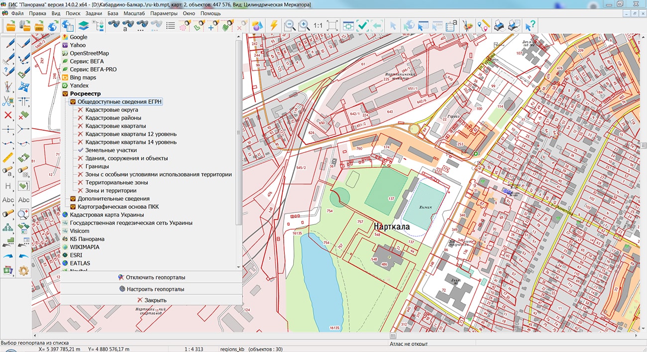
Specialists of KB "Panorama" prepared and placed the map of the Kabardino-Balkarian Republic on the geoportal . The map was formed using OpenStreetMap data, source data was obtained from website. To work with the map, you can use the program or other software products of KB "Panorama".
The map was led to the modernised classifier of large-scale plans of scale 1: 5 000 (map5000m) and was saved into a packed project (MPTZ). The MPTZ format project includes a digital map of the region's territory (country, subject of the federation, administrative region), a map of the administrative-territorial division of the region and a digital classifier. Publishing of updates in bank of spatial data is made by using the program of . Publishing contents of bank of spatial data on the geoportal and data access for downloading are implemented by means of .
Free maps on the basis of OpenStreetMap data are available for download on the page "Digital maps".


In KB "Panorama" the "Complex of agronomical tasks" version 6.12.1 has been developed. In the new version for the "Automatic determination of the contours of arable land" mode, the ability to select the processing area, both with a rectangular frame and with a closed polygon of arbitrary shape, has been added.
Until recently, there were three main modes for creating maps of agricultural land, differing in the cost of initial materials, labor costs and accuracy: decoding satellite images from open sources, digitizing orthophotomaps, processing data from GPS trackers. The most optimal of them in terms of the ratio of these indicators was considered to be the processing of data from GPS trackers. With the development of technologies based on neural networks, robotic decoding of raster data is becoming a more accurate and cheaper tool for creating vector maps of land parcels.
KB "Panorama" together with the company have developed the "Automatic determination of the contours of arable land" mode for the "Complex of agronomical tasks". The service, using artificial intelligence, analyzes the raster data available to it and constructs on their basis the vector maps of the working areas of the agricultural enterprise. Information processing is carried out on the territory selected by the user. It can be a rectangle or any arbitrary closed polygon.
An accurate digital model of farmland is the basis for all further agrotechnical calculations: maintaining field passports, constructing thematic cartograms, obtaining vegetation indices, maps of heterogeneity and the need for nitrogen, calculating the application of fertilizer doses, and others.
"Complex of agronomical tasks" is an additional module for , or GIS Panorama Mini. The complex is designed to create, edit, keep up to date, use and analyze electronic maps of fields together with an information base of the history of fields and soil fertility. The software package includes modes that provide information support for precision farming technology.
The new version of the "Complex of agronomical tasks" can be downloaded on our website in the Download section.


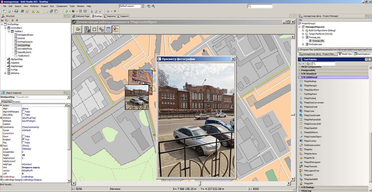
In KB "Panorama" the toolbox of version 14.0.2 has been developed for creating GIS applications in the environment of C++ Builder, Delphi Embarcadero. The new version includes tools for obtaining information about terrain objects using a combined technology for combining ground-based photographic materials with the results of remote sensing data. In the component for converting spatial data MapDataConversion there is added the function of loading photos in JPEG format containing GPS coordinates of the shooting location in EXIF tags. Typically, photographs taken with digital cameras and mobile phones equipped with a GPS receiver have such properties. Photos are loaded from the specified folder with photos. As a result, a service map will be added to the open document, containing point objects, for which semantics are automatically filled with a link to photo files. The service map is saved in the folder with the initial map and is added into the list of open maps. Photos on the map are displayed as icons (thumbnails). When the map is increased, the photos are also enlarged. The algorithm of an automatic clustering is applied for grouping of photos on a map at scaling. Densely located objects with photos are replaced with the first object in a cluster with indicating the number of photos in the given cell.
For viewing photos, the TMapManager component of map management has been improved, which allows to display a photo in a separate window when you click on an object. When programming, you can set the location and size of the window for viewing photos.
The GIS ToolKit consists of a set of visual components (supplied in source code) and API functions of the GIS core for direct access to spatial data. The toolkit is intended for the development of client-server and desktop 32-bit and 64-bit applications that require processing and visualization of spatial data. Spatial data can be located both at the workplace (direct access to data) and in a local network or the Internet (components of access to the or data exchange by international protocols are used).
The new version of the program is available for download on the page.


Specialists of KB "Panorama" prepared and placed the map of the Chuvash Republic on the geoportal . The map was formed using OpenStreetMap data, source data was obtained from website. To work with the map, you can use the program or other software products of KB "Panorama".
The map was led to the modernised classifier of large-scale plans of scale 1: 5 000 (map5000m) and was saved into a packed project (MPTZ). The MPTZ format project includes a digital map of the region's territory (country, subject of the federation, administrative region), a map of the administrative-territorial division of the region and a digital classifier. Publishing of updates in bank of spatial data is made by using the program of . Publishing contents of bank of spatial data on the geoportal and data access for downloading are implemented by means of .
Free maps on the basis of OpenStreetMap data are available for download on the page "Digital maps".


Specialists of KB "Panorama" have prepared a video lesson on creation of mathematical basis of the map. Users of the can independently create a rectangular and cartographic grid, as well as customize the display of these grids and other construction parameters.
In the training material a work with the tool is considered, which is available in the menu "Run Applications - Automatic creation of objects". The task is intended for creation of a mathematical basis for digital topographic maps of scale from 1:10 000 till 1:1 000 000 and for geographic maps of scale from 1:500 000 till 1:10 000 000. Most often, this tool is called to check the accuracy of placing raster images. When creating a mathematical basis for topographic maps, it is necessary that all the sheets of the region belong to the same six-degree zone.
You can get acquainted with the training materials in the "Video lessons" section.


Ph.: +7 (495) 739-0245, +7 (925) 221-1603
www.gisinfo.ru | panorama@gisinfo.ru
105005, Russia, Moscow, Baumanskaya Street 7, building 1, office 229 (m. Baumanskaya)
Copyright © Panorama Group 1991 - 2024


 Mobile version
 Full version