Copyright © Panorama Group 1991 - 2024

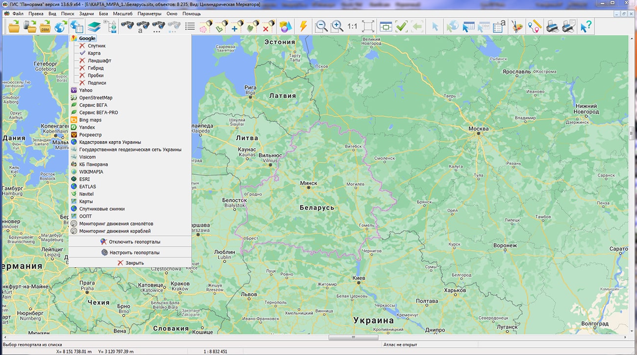
In KB "Panorama" a digital geographic map of scale 1: 1 000 000 in format SXF onto territory of the Republic of Belarus has been prepared. As a source for preparation of the map the obtained from the information from the site has served. The map contains information on the number of inhabitants for cities and the name of settlements in Russian. As additional materials the World map of scale 1: 5 000 000 and data were used.
The map was led to the classifier of geographic maps of scale 1: 1 000 000 (). It can be used for a general assessment of the area and the study of natural conditions, to ensure the educational process, as a basis for the creation of geographic maps of a smaller scale, thematic and special maps, and solving other tasks. The map is distributed free of charge under a free .
Digital geographic map of scale 1: 1,000,000 in SXF format is available for download on the page "Digital maps".


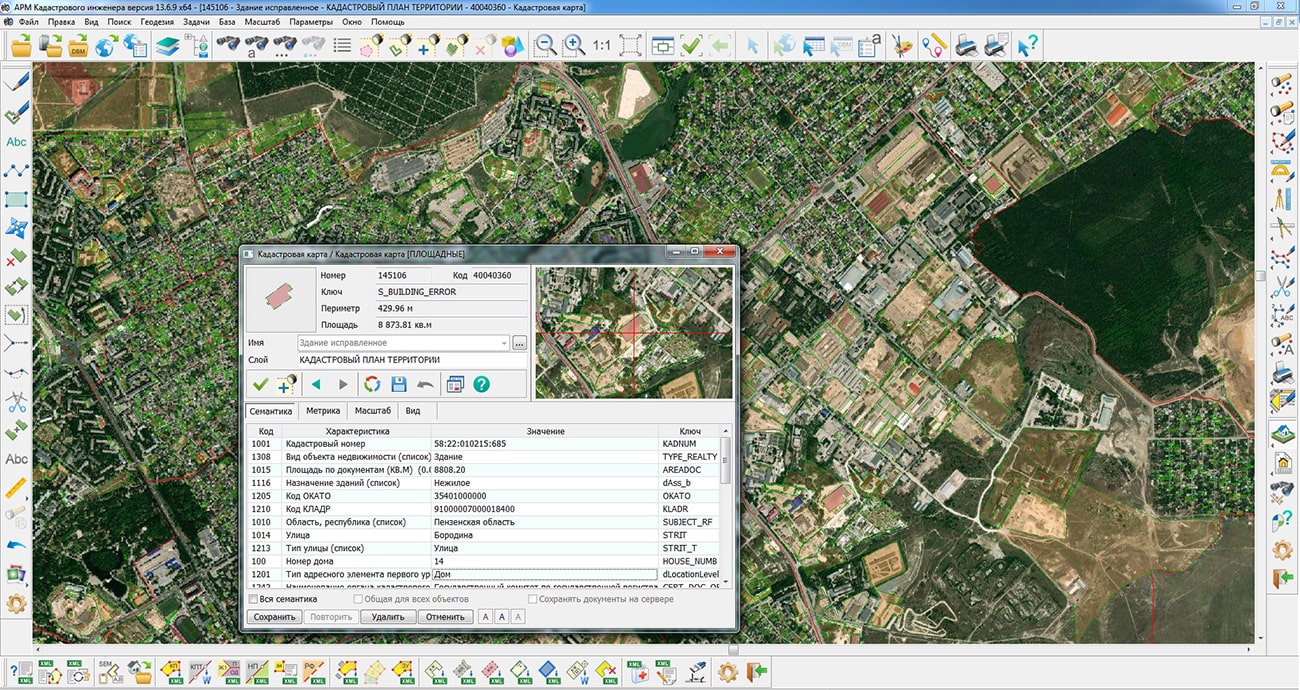
Specialists of KB "Panorama" have prepared a video lesson on the formation of an XML document and a paper report of the technical plan of version 06 release 4 on change of information about building. Users of "Workstation of cadastral engineer", or can form XML documents and paper reports of the technical plan by means of a complex of geodesy calculations.
The training material demonstrates the features of data preparation, filling in the mandatory characteristics and the formation of an XML file and a paper report of the technical plan in accordance with the Order of the Ministry of Economic Development of the Russian Federation from December, 18th, 2015 № 953. On the basis of this order in software products of KB "Panorama" the classifier of conventional symbols survey.v5.rscz has been developed. In the classifier there is implemented a general list of layers, semantic characteristics and objects for display of cadastral data on cadastral maps and other cadastral documents.
Technical plan can be formed for one or several objects of real estate depending on a variant of a selecting the objects on a cadastral map. Procedures "Formation of XML document and "Formation of a text report" are performed in the dialog. The initial initialization of the dialog content and the specifying the type of real estate object is performed based on information from the digital cadastral map, taking into account the chosen mode of formation.
Elements for entering and editing data in the "Technical plan" dialog are sorted into groups, in accordance with the sections and details of the technical plan, and arranged by screen pages (bookmarks): , , , , , , .
You can get acquainted with the training materials in the "Video lessons" section.


Specialists of KB "Panorama" prepared and placed the map of Mongolia on the geoportal . Source data was obtained from website. To work with the map, you can use the program or other software products of KB "Panorama".
The map was led to the modernised classifier of large-scale plans of scale 1: 5 000 (map5000m). Publishing of updates in bank of spatial data is made by using the program of . Publishing contents of bank of spatial data on the geoportal and data access for downloading are implemented by means of .
Free maps on the basis of OpenStreetMap data are available for download on the page "Digital maps".


Specialists of KB "Panorama" have prepared a video lesson demonstrating the possibilities of the mode. Users of the can independently convert vector maps using the presented tool into files of format GML and GeoJSON.
Video lesson demonstrates the settings of the export's tool: creation of styles, semantics and metrics in the created GML (GeoJSON) file, creation and use of the data schema, modes for creating maps and sheets, compiling a list of object types. The tool "Export of vector data to GML or JSON format" is intended for export of vector maps from the GIS "Panorama" into files of format GML and GeoJSON. Users can change the export's parameters: specify the data format, set the coordinate system, set the mode for creating styles, metrics, semantics and metadata, select the parameters for saving several maps or sheets, and also specify or independently create application data schemes using the classifier editor in the GIS "Panorama ". The result of the converter work is recorded into the protocol.
You can get acquainted with the training materials in the "Video lessons" section.


In KB "Panorama" the version 10.0 has been developed. GIS Server provides remote access to spatial databases, digital maps of the area, remote sensing data, matrixes and documents. In the new version the list of supported DBMS for work with spatial databases has been expanded: PostgreSQL with PostGIS extension (St_Geometry data type), Oracle with Oracle Spatial extension (SDO_GEOMETRY data type), Oracle with ArcSDE extension (St_Geometry data type).
The program implements a new algorithm for monitoring virtual folders and controlling access rights to accelerate access to data with a large number of clients and a high intensity of operations for creating and deleting data sets in virtual folders. GIS Server supports automated data access control at the level of virtual data folders. The administrator can specify the rights of individual user groups to access different folders, without detailing the contents of the folders and their structure. In the process of work, the GIS Server automatically scans the contents of the folders and grants the users belonging to the corresponding group the rights to the data that will be placed in the virtual folder. The user can remotely change the structure of virtual folders and the composition of the data in them. When the contents of the folder are changed, the tree of available data is automatically rebuilt, which is displayed on the client when data is selected. This allows you to dynamically change the composition of data in a folder, add and delete data without interrupting the work of the GIS Server and without using administration tools for each instance of data.
There is added a support of publishing the packaged MPTZ projects, inside which other packaged projects are stored (reports with inserts and similar datasets). When a user enters several Active Directory groups, the rights to edit data are granted if there is access to this data for editing at least in one group.
Updating the GIS Server program from version 9 to version 10 for those who purchased the program after June 1, 2020 or has the paid technical support, free of charge.
The new version of the program is available for download on the page.


Ph.: +7 (495) 739-0245, +7 (925) 221-1603
www.gisinfo.ru | panorama@gisinfo.ru
105005, Russia, Moscow, Baumanskaya Street 7, building 1, office 229 (m. Baumanskaya)
Copyright © Panorama Group 1991 - 2024


 Mobile version
 Full version