Copyright © Panorama Group 1991 - 2024

Specialists of KB "Panorama" have prepared a set of examples demonstrating technologies for working with spatial databases. The set includes archives of demo databases that can be deployed in PostgreSQL, Oracle and Microsoft SQL Server, and also a project of maps intended for use in . Access to spatial databases (DB) running under the control of "industrial" DBMS PostgreSQL, Oracle, Microsoft SQL Server is implemented at the level of the geoinformation core and is supported in the and applications of KB "Panorama", as well as in applications based on the geoinformation core "Panorama" with use of the MAPAPI interface or components from toolset of and .
Demonstration spatial databases contain a fragment of the map of the city of Petrozavodsk in the Republic of Karelia, divided into separate thematic layers (hydrography, road network, buildings, etc.), which are physically represented in separate database tables. Each such spatial layer corresponds to a *.dbm file included in the demo. The * .dbm file is required for opening a spatial layer from a database. In the software products of KB "Panorama", both a separate spatial layer and the whole map can be opened. For this, a map project (*.mpt) is used that combines several spatial layers.
The demo example for each of the above DBMSs includes a readme.ru.txt file containing instructions for deploying a demo spatial database. Demonstration examples of spatial databases are available for download in the Download section.


Geoportal has been supplemented with a map of England, formed according to OpenStreetMap data. Source data were obtained from website. To work with the map, you can use the program or other software products of KB "Panorama".
The map was led to the modernised classifier of large-scale plans of scale 1: 5 000 (map5000m.rsc). Publishing of updates in bank of spatial data is made by using the program of . Publishing contents of bank of spatial data on the geoportal and data access for downloading are implemented by means of .
Free maps on the basis of OpenStreetMap data are available for download on the page "Digital maps".


In KB "Panorama" the version 9.4 has been developed. In the new version a support of access to the format has been added. The packaged project may include a comprehensive representation of the territory in the form of vector maps of different levels of detail, terrain images in RSW format, matrixes of heights and matrixes of terrain quality characteristics. The virtual folder on the GIS Server can be supplemented/updated by MPTZ projects in the background mode, changing the area and detail of the background cartographic coverage and the composition of remote sensing data without additional data administration. To read MPTZ, the client must be version 13.6.3 or higher.
Support for the formats , SITZ, MAPZ, MPTZ has been added to the procedure for backup of vector maps. The SITZ, MAPZ, MPTZ extensions have been added into the filter of vector maps for monitoring virtual folders. The protocol for loading data sets into the Databank of the Digital Maps and ERS is written in UTF-8 encoding. Calculation of checksums of files when writing into the is performed using the CRC32 algorithm. The program has improved the caching of packed sitz\mapz maps opened from another server. The algorithm for backup of DBM files has been changed to exclude the background opening of the spatial database without an explicit client request. The dongle driver has been updated from version 6 to version 7 for correct operation of the network license.
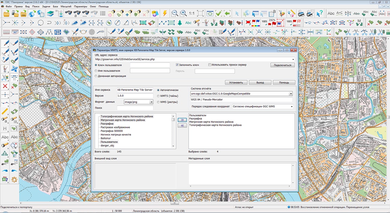
The GIS Server is designed to provide remote access to vector maps, remote sensing data, matrixes, documents and spatial databases of users of the programs the , , and others. Users of desktop and web applications on different platforms can simultaneously view and edit data in accordance with access rights.
The new version of the program is available for download on the page.


In KB "Panorama" the version 13.6.3 has been developed. In the new version the tools of information interaction with Federal State Information System of Territorial Planning have been improved. In the program the mode of saving schemes of territorial planning and maps of master plans in GML format has been updated. For an unloading of maps in local or local coordinate system for which there is no EPSG code, it is possible to set value equal to zero. During the import and export of territorial planning schemes and master plans with zero EPSG code, a message appears - invalid EPSG code for the TP scheme, the error is recorded into the protocol, but the work is not interrupted. It allows to unload the information for transfer to FSIS TP.
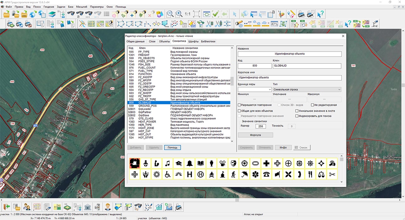
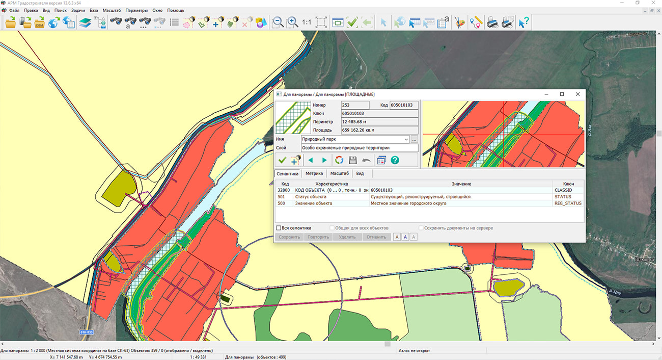
To implement the requirements for describing and displaying objects of federal, regional and local significance in territorial planning documents, in accordance with the appendix to order № 10 of the Ministry of Economic Development of Russia, KB "Panorama" has also developed a terplan.v4.rscz digital map classifier, which contains the required list of objects and attributes. "Workstation of urban planner" supports the creating and editing the maps of territorial planning's documents and their unloading into exchange formats. In the new version of the program, the mode of export to SHP of schemes of territorial planning and master plans maps has been improved. There is added an automatic filling with default values for required attributes GLOBALID - object identifier and CLASSID - object code. The GUID of the map object is used for filling the GLOBALID. To fill in the CLASSID, semantics with code 32800 is used. If it is absent in the object, then the classification code of the object from the classifier is recorded.
In FSIS TP, it is allowed to place approved and project documents of territorial planning both in vector and in raster form. To increase the speed of loading raster data from FSIS TP in the "Workstation of urban planner" the import of graphic files of the GeoTIFF, PNG, JPEG and other formats into the RSW format has been improved. Due to the use of multithreaded processing on a multicore processor, the task execution time has been reduced by 3-6 times. The control example from 384 GeoTIFF files in volume of 45 GB was processed for 57 minutes instead of 190 minutes in the previous version of the program.
The new version of the program is available on the website in the Download section.


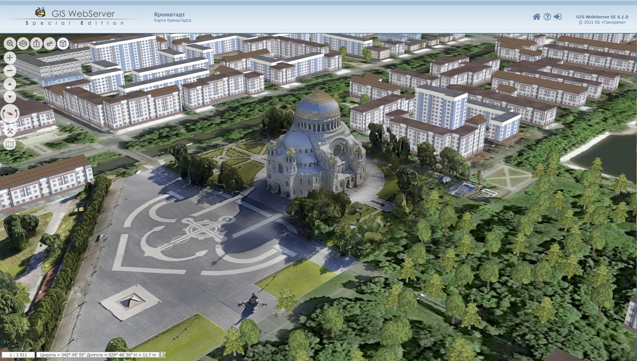
KB "Panorama" has prepared a new project of a three-dimensional model of the territory of to demonstrate the possibilities of three-dimensional modeling of a universal GIS for constructing geoportals for various purposes . The project contains data from open sources: images, maps on the basis of OpenStreetMap data, elevation data. The three-dimensional view of the map objects is built dynamically with using the templates of models specified in the library of three-dimensional models of objects of the classifier of digital plans of cities at a scale of 1: 5 000 map5000m.rscz. Such approach allows to quickly obtain 3D terrain model which will correspond to all changes of objects on a two-dimensional map. The presence in the library of models of near and far three-dimensional view accelerates the display of the terrain model in general, with the possibility of more detailed display of objects nearby. The project includes models of the Moscow Kremlin, Red Square, the Cathedral of Christ the Savior, Zaryadye Park and other sights and outstanding objects of the capital. They were prepared by the designers of KB "Panorama" using photographic materials and reference information in the editor of three-dimensional models and tied to the terrain using the import of three-dimensional models in the task "Navigator 3D" in the . The import is made into a database of 3D-tiles of spatial data in DB3D format to display accurate and realistic 3D models of unlimited size.
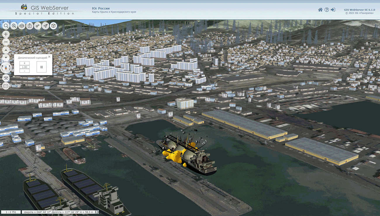
A new example of the dynamic scenario "Emergency Scenario in Novorossiysk" has been added into the project. The project itself is also made on the basis of data from open sources. The scenario was created in the "Navigator 3D" task in the GIS "Panorama" using the operator.rscz classifier of objects of operational situation and its . Creation and playback of dynamic scenarios allows you to simulate and calculate actions, their time and sequence for various services in case of emergencies.
The updated are designed to show the variety of data, on the basis of which a high-quality three-dimensional model of the terrain can be obtained when building geoportals for various purposes with using the GIS WebServer SE. In the projects of , , , , , a three-dimensional terrain model is built using maps of a unified cartographic base. Projects of , , , , demonstrate the capabilities of models using laser scanning of the terrain.
GIS WebServer SE automates the publication of changing spatial data based on web services. The program creates new layers of data and allows you to edit them. GIS WebServer SE provides access to user data from any computer, displays a 3D model using open vector maps, matrixes of heights and terrain images without preparing a model. Allows to create thematic maps and cartograms, carries out search of the shortest routes in the graph of roads.


Ph.: +7 (495) 739-0245, +7 (925) 221-1603
www.gisinfo.ru | panorama@gisinfo.ru
105005, Russia, Moscow, Baumanskaya Street 7, building 1, office 229 (m. Baumanskaya)
Copyright © Panorama Group 1991 - 2024


 Mobile version
 Full version