Copyright © Panorama Group 1991 - 2024

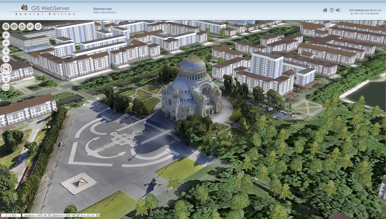
KB "Panorama" has prepared a new project of a three-dimensional model of the territory of to demonstrate the possibilities of three-dimensional modeling of a universal GIS for constructing geoportals for various purposes . The project contains data from open sources: images, maps on the basis of OpenStreetMap data, elevation data. The three-dimensional view of the map objects is built dynamically with using the templates of models specified in the library of three-dimensional models of objects of the classifier of digital plans of cities at a scale of 1: 5 000 map5000m.rscz. Such approach allows to quickly obtain 3D terrain model which will correspond to all changes of objects on a two-dimensional map. The presence in the library of models of near and far three-dimensional view accelerates the display of the terrain model in general, with the possibility of more detailed display of objects nearby. The project includes models of the Moscow Kremlin, Red Square, the Cathedral of Christ the Savior, Zaryadye Park and other sights and outstanding objects of the capital. They were prepared by the designers of KB "Panorama" using photographic materials and reference information in the editor of three-dimensional models and tied to the terrain using the import of three-dimensional models in the task "Navigator 3D" in the . The import is made into a database of 3D-tiles of spatial data in DB3D format to display accurate and realistic 3D models of unlimited size.
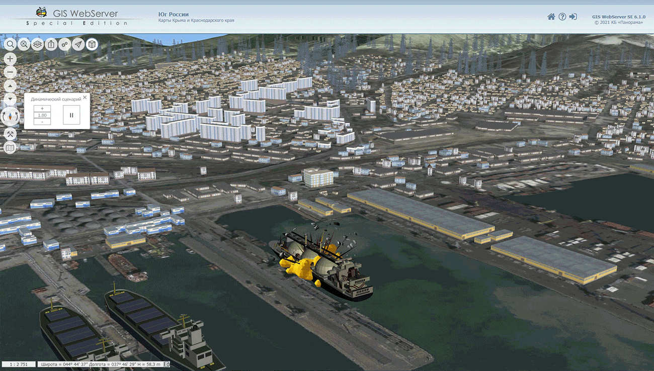
A new example of the dynamic scenario "Emergency Scenario in Novorossiysk" has been added into the project. The project itself is also made on the basis of data from open sources. The scenario was created in the "Navigator 3D" task in the GIS "Panorama" using the operator.rscz classifier of objects of operational situation and its . Creation and playback of dynamic scenarios allows you to simulate and calculate actions, their time and sequence for various services in case of emergencies.
The updated are designed to show the variety of data, on the basis of which a high-quality three-dimensional model of the terrain can be obtained when building geoportals for various purposes with using the GIS WebServer SE. In the projects of , , , , , a three-dimensional terrain model is built using maps of a unified cartographic base. Projects of , , , , demonstrate the capabilities of models using laser scanning of the terrain.
GIS WebServer SE automates the publication of changing spatial data based on web services. The program creates new layers of data and allows you to edit them. GIS WebServer SE provides access to user data from any computer, displays a 3D model using open vector maps, matrixes of heights and terrain images without preparing a model. Allows to create thematic maps and cartograms, carries out search of the shortest routes in the graph of roads.


In KB "Panorama" the has been developed. The new version expands the list of supported DBMS for working with spatial databases: PostgreSQL with the PostGIS extension, Oracle with the Oracle Spatial or ArcSDE extension, Microsoft SQL Server. Database connection parameters (table, data view or SQL query) are customized in the database connection administration dialog and saved in a file with the DBM extension, which has an XML structure. The settings provide for entering the name of the DBM file, the mode and parameters of connecting to the database, creating the lists of displayed and edited objects and their semantic characteristics (attributes). GIS "Panorama" provides direct display and editing of arbitrary spatial databases in cartographic conventional symbols, including those created by other GIS, without additional third-party modules based on direct interaction with PostgreSQL, Oracle and MS SQL Server DBMS through SQL queries.
Possibility has been added for displaying a packed project of spatial data MPTZ from the of version 9.4 and higher. A packaged project may include a complex representation of the territory in the form of vector maps of different levels of detail, images of the terrain in RSW format, matrixes of heights and matrixes of quality characteristics of the terrain, insets from the same data, the reference to data from the GIS Server and from geoportals by various protocols. All data sets are packed into one file of MPTZ format. The total amount of packed data is reduced by 3-10 times. The speed of data exchange, packed into an MPTZ project, increases 5-20 times, taking into account the decrease in the number of transferred files. The size of the MPTZ file and the number of sets in the project are not limited. Maps are packed together with classifiers, a tree of distribution of objects over the map area, multiscale objects (generalized contours for different display scales) and hash tables indexed for search of objects semantics, pyramids of raster tiles and matrixes, which provides high speed of display and data search. The virtual folder on the GIS Server can be supplemented/updated by MPTZ projects in a background mode, changing the area and detail of the background cartographic coverage and the composition of remote sensing data without additional data administration. Packaged MPTZ projects can be formed by region (as, for example, on Digital maps page) or according to nomenclature sheets (for example, at a scale of 1: 500 000), which allows you to quickly form a complex coverage of a given territory.
In the task of importing graphic files (GeoTIFF, PNG, JPEG and others), a loading the pyramid of raster tiles from the KMZ format has been added. A KMZ archive can contain a KML file and a set of raster files. The KML file contains a description of parameters of the raster data - the names and coordinates of a binding of rasters, and also the priority of their rendering. As a result of importing a pyramid of raster tiles from KMZ, a set of RSW files is formed combined into an MPT project. The MPT project contains a list of rasters in RSW format and the visibility borders of the rasters according to the "Draw Order" parameter.
In the task of importing matrixes from SRTM, GeoTIFF formats, loading of the pyramid of matrixes of heights of a relief from the KMZ format has been added. The KMZ archive contains a KML file and a set of single-channel GeoTIFF files with data on elevation heights, from which a set of MTW files is formed combined into an MPT project with specified matrix visibility borders in accordance with the "Draw Order" parameter.
The speed of searching for objects with given semantic characteristics is increased by an average of 1 000 times due to the indexing of semantics values using polynomial hashing methods, building reference books of values and other improvements of search algorithms. In a test case of 4 000 000 objects, a search was performed using three indexed semantics: "Name", "Number of inhabitants", "Unique object identifier", which were filled in for more than 3 350 000 objects. The speed of performing sample of objects has decreased from 4 seconds to 4-5 milliseconds. The additional amount of RAM for placing the hash tables was 95 MB, the size of the original map was 802 MB. To activate the construction of hash tables, it is necessary to enable the "Index for search" option in the Classifier Editor for the semantics used when searching for objects. To reduce the time for building hash tables, they are saved into a file with the ".seh" extension and read when the map opening. When saving a map in the packed SITZ\MAPZ\MPTZ format, hash tables are packed in a common archive with the map. The new algorithm makes it possible to execute more requests on search from application tasks in multithreaded mode and improve the performance of server applications.
When importing GeoTIFF files, analysis of GeogCitationGeoKey and PCSCitationGeoKey tags has been added to support GSK-2011 and PZ-90.11 coordinate systems. Tag GeogCitationGeoKey can contain records of the type: "PZ-90.11 Zone 6" or "GSK-2011 Zone 7". The contents of the GeogCitationGeoKey and PCSCitationGeoKey tags supplement the numeric coordinate system parameters specified by other tags.
In the task of editing the list of semantics, for convenience and acceleration of work, the ability to copy and paste semantics values by using the clipboard has been expanded. Copying to the clipboard is carried out by a combination of hot keys Ctrl+Ins, Ctrl+C, paste - Ctrl+V. The insertion of semantics value is supported both for a separate object and for objects in the selected range of cells of the semantics table. Selection of lines is carried out by holding the left button of the computer mouse. Insertion is possible for assigning a semantic value of one code to all table objects. For this, the "Paste from clipboard" item is assigned in the context menu.
To display polygons with a point symbol, a new property of objects in the "Classifier Editor" has been added - "Polygon with a point". For objects with this property, when creating and editing an object, or when sorting, a subobject with one point in the center of the polygon is automatically created. If a conventional symbol of polygon contains polygon parameters and parameters of a point or vector symbol, the corresponding symbol will be displayed in the center of the polygon. The user can change the position of the point in the "Map Editor".
Classifier survey.v5.rscz has been updated. To increase the speed of searching for objects by the value of semantic characteristics, the "Index for search" option is enabled for the following semantics: "Name", "House number", "Cadastral number", "Registration number", "Designation", "Forest block number", " Cadastral numbers of plots where the property is located", "Cadastral numbers of premises located in the property", "Cadastral numbers of parking spaces located in the property", "Cadastral number of a single immovable complex", "Plot number", "Surname of owner". In the classifier map5000m.rscz the option "Index for search" is enabled for the following semantics: "Name", "House number", "Designation", "City name", "District name", "Street name ","Village name". In the classifiers of digital topographic maps of scales 1: 25 000 - 1: 1 000 000, the "Index for search" option is enabled for the following semantics: "Name", "Number of inhabitants", "Political and administrative value", "Road number", "Number houses, pits, wells, etc.", "Number of inhabitants on a scale", "Name, text of the title in the national language "," Purpose of object ".
The new version of the program is available for download in the section.


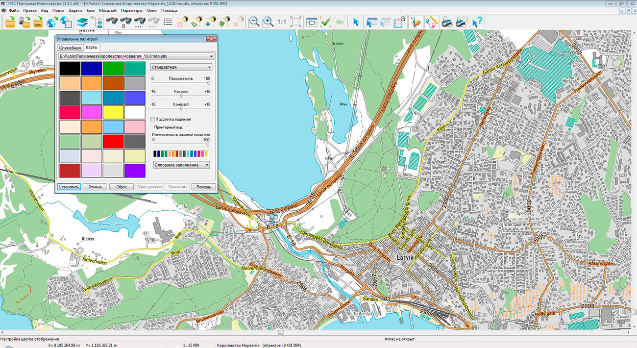
Geoportal has been supplemented with a map of the Kingdom of Norway, formed according to OpenStreetMap data. Source data were obtained from website. To work with the map, you can use the program or other software products of KB "Panorama".
The map was led to the modernised classifier of large-scale plans of scale 1: 5 000 (map5000m.rsc). Publishing of updates in bank of spatial data is made by using the program of . Publishing contents of bank of spatial data on the geoportal and data access for downloading are implemented by means of .
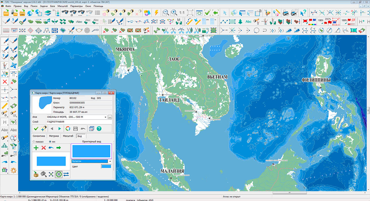
Free maps on the basis of OpenStreetMap data are available for download on the page "Digital maps".


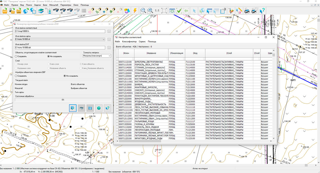
In KB "Panorama" the Converter of large-scale plans into DXF format version 8.4 has been developed. The program allows you to create a large-scale topographic map or plan in DXF format in standard conventional symbols used for cartographic work in the Russian Federation. The creation, quality control and designing of the map in SXF format using RSC classifiers are preliminarily performed. The prepared maps are converted into DXF format in compliance with the uniform requirements for the design of conventional symbols for maps and plans. The delivery set includes classifiers and libraries of conventional symbols in DXF format for large-scale maps and plans of scales : 500, 1: 1 000, 1: 2 000, 1: 5 000.
In the new version, it is possible to get a list of reference blocks and line styles that are in the block of the drawing description. The functionality of unloading the settings of the correspondence file into the MS Excel format has been improved. It allows to make the additional analysis of parameters of converting and to print them. The visual interface has been updated and help in the html format has been added. The GIS core of the program has been updated to version 13, which improves the performance of the program when processing data.
The new version of the program is available for download on the Download page.


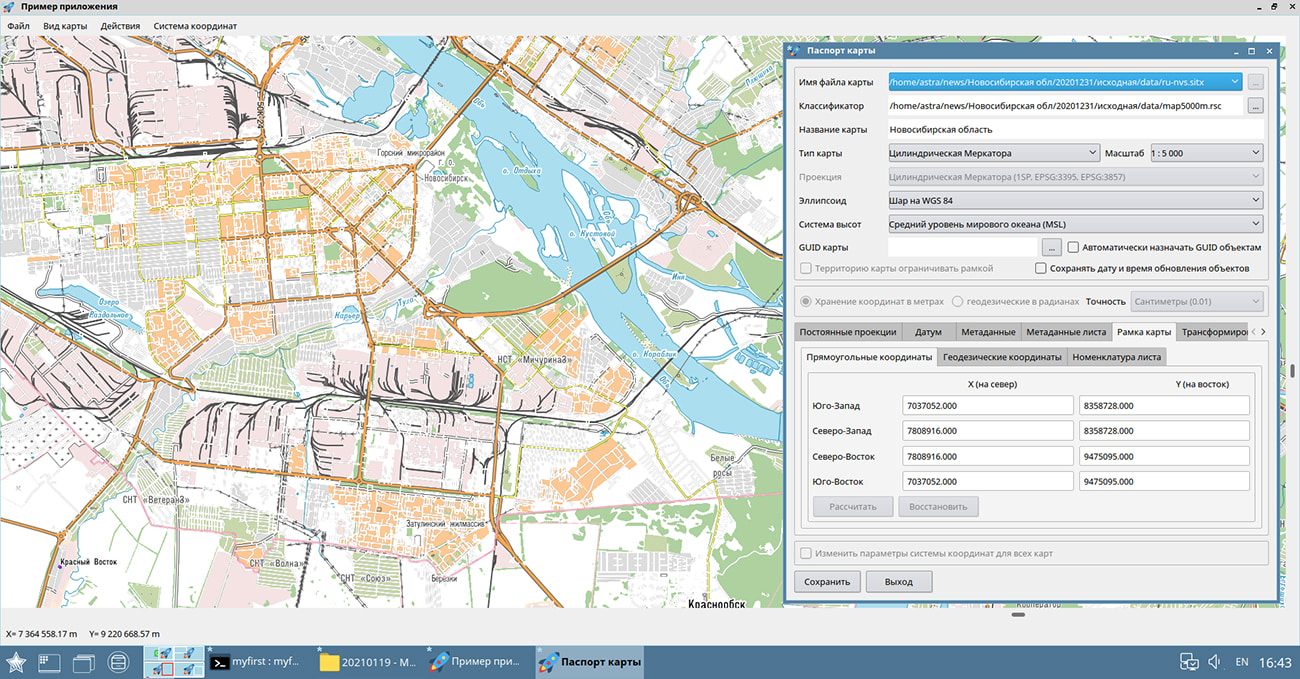
In KB "Panorama" the for Qt Designer SE version 13.4.0 has been developed for operating systems CentOS, Ubuntu, Astra Linux SE. In the new version, the transformation of vector maps into a preset coordinate system has been accelerated by 4-6 times. This expands support for both embedded devices, which have processor performance limitations, and high-performance systems, where it is necessary to use the available processor power maximally. When adding a map with transformation, a copy of the original map is created in the map subdirectory with a name containing the name of the passport file and the current date. Additionally, the opening and first display of maps has been accelerated due to the formation of a "*.sol" file with a tree of territorial distribution of objects onto each map sheet. When the map is opened, the objects tree is read and the first display is accelerated by 5-15 times (for a map with 2 million objects, the opening and first display is accelerated from 9-12 seconds to 1 second). When sorting a map in SITZ\MAPZ format or saving an MPTZ project, the tree of objects is saved in a packed data file with further acceleration of the first opening of a map. In the absence of the "*.sol" file the automatic constructing a tree and file saving are carried out.
When saving and opening the projects of maps in MPT\MPTZ format, the currently specified contents of display for each project map is taken into account. Into a project file the records of XML format in the form of sections with the name [#xml#vclxNNN] have been added. It allows to form from one set of maps the projects of different composition of layers, scale, color design for use in the form of inserts in various reports and other tasks.
This allows duplicate columns of sheets in the western and / or eastern hemispheres to expand the dimensions of the work area up to -360 / + 360 degrees. To duplicate sheets, you need to copy the required file with a different name (for example, rename 01-12.sxf to 01-12_west.sxf) and change its nomenclature so that all sheets in the region have a unique designation (for example, rename 01-12 to 01-12_west ). Then, in a text editor, add a line with a new name sxf or txf to the DIR file and press tab after the file name and enter the direction of hyphenation (for example, -360 or +360). Recalculation of coordinates and sheet passport will be performed automatically when importing a work area using a DIR file.
When importing a set of maps sheets of SXF and TXF format, specified by the list in the DIR file, the ability has been added for transfer of sheets by longitude on +/-360 degrees. It allows to duplicate the columns of sheets in the western and\or eastern hemisphere for expansion of dimensions of work region up to -360/+360 degrees. To duplicate sheets, copy the required file with a different name (for example, rename 01-12.sxf to 01-12_west.sxf) and change its nomenclature so that all sheets in the region have a unique designation (for example, rename 01-12 to 01-12_west ). Then, in a text editor, add a line with a new name sxf or txf into the DIR file and press the tab after the file name and enter the direction of transfer (for example, -360 or +360). The recalculation of coordinates and sheet passport will be performed automatically when importing the work region by the DIR file.
The display of DEMs has been improved: the color of the coverage point is calculated based on 16 adjacent heights using the bicubic interpolation method. The new method makes it possible to smooth the discreteness of the display of the matrix elements and the light-shadow mask (hillshade) of the relief, as well as to cut the image of the matrix by the frame with pixel accuracy. To display DEMs with smoothing, you must enable the main menu item Options\Display matrix with smoothing.
The functionality of the QDMapWindow digital map display component has been expanded. The component implements the ability to open a fragment of a map bounded by a frame. This functionality allows you to work with a small area of the map, increasing the convenience and speed of work due to providing access only to the required data.
GIS Constructor is a set of geoinformation components for use in the visual programming environment of Qt Designer, which allows you to develop your own GIS applications. The visualization of the contents of digital maps is made in conventional symbols adopted for topographic, geographical and various special maps. Geoinformation system has ample opportunities for performing calculations, for providing display of spatial data on various graphic devices in standard and user systems of conventional symbols. The main functions can be executed in multithreaded mode. It supports automatic optimization of used memory for processing large amounts of data (tens of gigabytes) on limited resources (hundreds of megabytes).
The toolkit is adapted for work on a wide range of operating systems (Astra Linux SE, ALT Linux, Elbrus, Ubuntu, CentOS, QNX) and architectures (Intel, Elbrus, PowerPC, SPARC, ARM). The toolkit includes components of visual designing the GIS applications and library of a multiplatform multithreaded GIS core. GIS Constructor provides a cross-platform MAPAPI interface that allows a programmer to implement development in an operating system convenient for it. The developer can release GIS applications for a set of operating systems by simple assembly with minimal changes to the program source code.
The new version of the program is available for download in the section.


Ph.: +7 (495) 739-0245, +7 (925) 221-1603
www.gisinfo.ru | panorama@gisinfo.ru
105005, Russia, Moscow, Baumanskaya Street 7, building 1, office 229 (m. Baumanskaya)
Copyright © Panorama Group 1991 - 2024


 Mobile version
 Full version