Copyright © Panorama Group 1991 - 2024

In KB "Panorama" the has been developed. In the new version, the transformation of vector maps from one coordinate system to another has been accelerated by 4-6 times.The task is called from the menu "Tools\Coordinate systems\Standard transformation" or when adding maps in different coordinate systems. When adding a map with transformation, a copy of the original map is created in the map subdirectory with a name containing the name of the passport file and the current date.
Import of graphic files of GeoTIFF, PNG, JPEG and other formats into RSW format is accelerated by 3-6 times due to the use of multi-threaded processing on a multi-core processor. A test case from 384 GeoTIFF files in volume of 45 GB has been processed in 57 minutes instead of 190 minutes in the previous version.
The optimization of the list of rasters in RSW format is 2-4 times faster due to the use of multi-threaded processing on a multi-core processor: compression, decompression and updating of general images of rasters (pyramids of tiles). A test case of 384 rasters with a total size of 125 GB is compressed using the JPEG algorithm up to 2.37 GB in 25 minutes instead of 48 minutes in the previous version of the program.
Import of matrixes of heights and quality characteristics from HGT (SRTM), GeoTIFF and IMG files has been accelerated 3-5 times due to the use of multi-threaded processing on a multi-core processor. The test set from 379 GeoTIFF files in volume of 44 GB was processed in 44 minutes instead of 156 minutes in the previous version of the program.
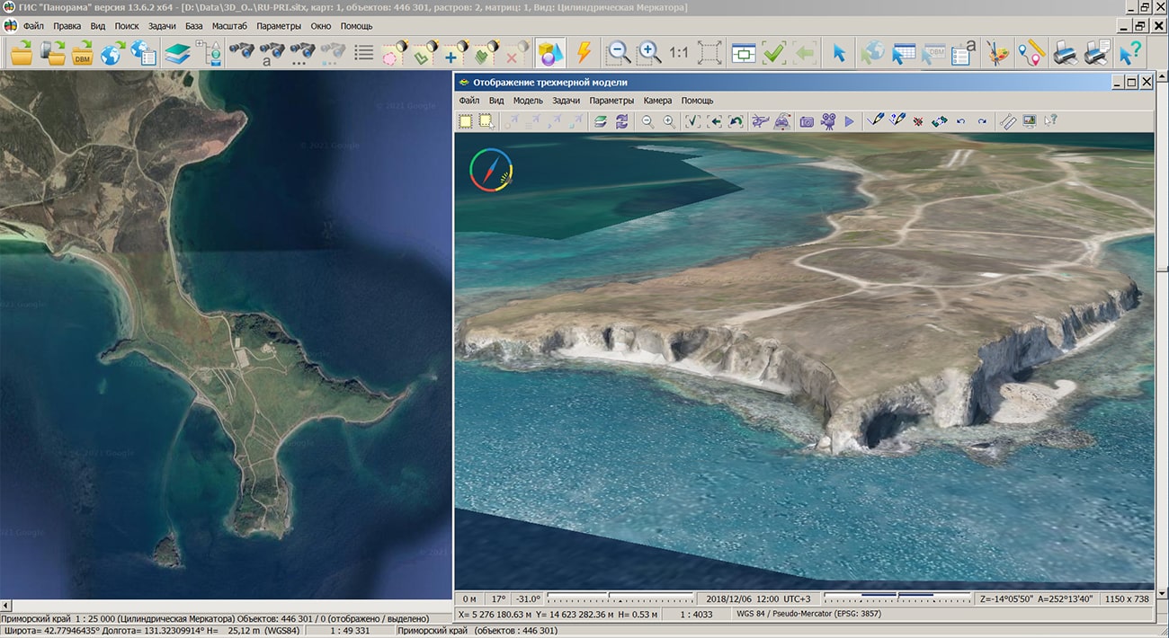
The tasks "Raster passport" and "Matrix passport" have been improved. The bookmark "Metadata" has been added, on which the code EPSG, a filename of metadata and the size of image or matrix in kilobytes have been specified. For editable raster or matrix files, saving metadata into an XML file is available. The metadata of images and matrices can contain the characteristics of the dataset (accuracy, coordinates of dimensions, conditional name, classification, etc.), as well as information about the organization and employees who create the sets.
In the "Floor Plan Editor" the mode "Adding text" has been added. The mode is intended for drawing titles, explanatory captions and other texts onto the map. In the process of entering and editing text, the main standard tools of a regular text editor are available: moving the cursor (arrow keys), keys "Delete", "BackSpace", "Home", "End". In the process of entering and editing text, you can insert text fragments from the clipboard, change the orientation of the text relative to the anchor point (left, center, right), the position of the text on the map, the text font.
There is improved a display of vector signs that look like a frame with text inside and other elements. In the "Editor of a vector sign" the "[T]" button has been added - Select a text chain to specify the size of the sign. In order for the sign to change its width when changing the text of a chain, it is necessary to specify in the list of chains the text element by which the width of the sign will be controlled and press the "[T]" button. [T] will be displayed to the left of the selected string. You need to choose the chain, the text of which is most likely to be longer than the rest. The chain coordinates should be closer to the edges of the frame so that when the sign is stretched proportionally, empty areas are not formed at the edges of the signature. Stretchable signs can be used in aeronautical maps (zones labels), topographic maps (a road number in a frame), operational maps (signature inside a flag) and others.
The task of connecting geoportals has been improved. Ability has been added to simultaneously connect several layers according to the international standard OGC WMS or OGC WMTS through the "Open map from WMS server" dialog. In this case, each layer will be added as a separate connection into the general list.
The dialog "Opening data from GIS Server" has been improved. For users who have the right to view the state of the operation, in the "Monitoring" bookmark, the ability has been added to save the log (protocol) of the server operation to a text file for further analysis or sending to the technical support service.
The task "Control of absolute heights" has been improved. Control of heights in areas of areal rocks has been added. When searching for unacceptable elevation differences along the selected profile, it is determined that the drop point hits the inside of the areal rock, where such differences are possible. If it hits, the message is logged; if the "Issue warnings" mode is set, this mode is disabled by default. The refinement reduces the number of messages, which makes it easier to analyze the control result. The number of sections for horizontal and vertical profiling of objects with absolute height has been increased. For linear and areal objects, instead of one profile, three are built - in the center and at the edges of the dimension, which helps to reduce misses when searching for unacceptable height differences.
The "View error" mode of the "Map Editor" task has been improved. Possibility of saving records about the detected errors into a text file of CSV format has been added. CSV format is supported by spreadsheets and database management systems. The log can contain messages from any tasks that generate warnings: messages about errors in semantics, double points in the metric, the presence of loops, errors of subobject occurrence, mismatch of the contours of objects, intersection of the contours of objects, messages about mismatch of heights, missing contours, errors in elevation marks, mismatch of semantics of adjacent objects of adjacent sheets and others. For the each record of the file of the map control's protocol, the text of the message and information for identifying the object for which this message was generated (unique object number, sheet number, sheet name, point coordinates) can be placed into the CSV file.
The classifier of aeronautical maps dfc.rsc has been updated. There are clarified the conventional symbols of objects, the width of which depends on the length of the signature in the symbol: 5100300 Signature of landing course, 4000600 Signature of control area (CTA) without transition altitude, 4000800 Signature of Flight Information Sector (FIS), 4000200 Signature of Flight Information Region (FIR), 4000200 Signature of the control area (CTA), 4000200 Signature of the Aerodrome Flight Information Zone (AFIZ), 4000200 Signature of the restricted zone of P-zone, 4000200 Signature of the danger zone of the D-zone, 4000200 Signature of the R-zone flight restriction zone, 4000200 Signature of TSA Temporary Reserved Airspace, 2001200 Signature of terminal turning point, 2001200 Signature of waypoint RNAV, 2000510 Signature of ILS. When you change the text of the signature selected in the sign, the width of the sign will be automatically changed so that the text remains within the frame.
The new version of the program is available for download in the section.


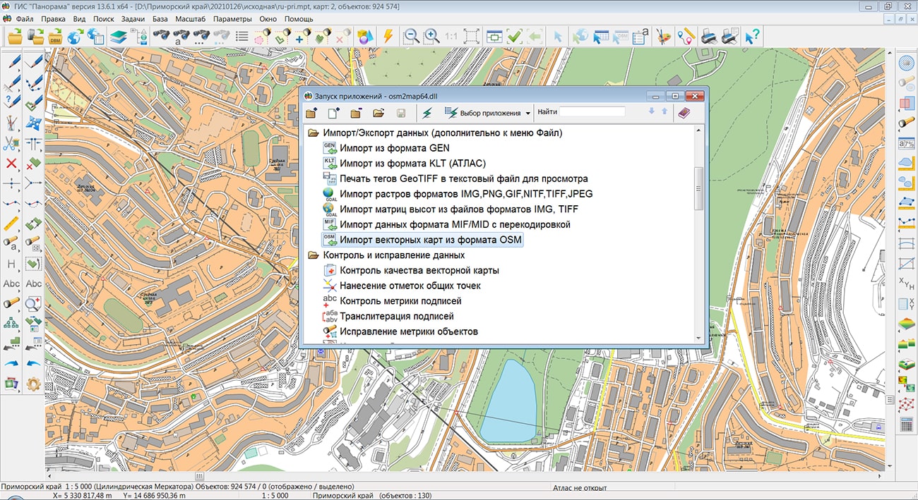
Specialists of KB "Panorama" prepared and placed on the geoportal the maps of the Republic of Buryatia and Primorsky Krai. The maps were formed using OpenStreetMap data, source data was obtained from website. To work with the maps, you can use the program or other software products of KB "Panorama".
The maps were led to the modernised classifier of large-scale plans of scale 1: 5 000 (map5000m.rsc) and were saved into a packed project (MPTZ). The MPTZ format project includes a digital map of the region's territory (country, subject of the federation, administrative region), a map of the administrative-territorial division of the region and a digital classifier. Publishing of updates in bank of spatial data is made by using the program of . Publishing contents of bank of spatial data on the geoportal and data access for downloading are implemented by means of
Free maps on the basis of OpenStreetMap data are available for download on the page "Digital maps".


In KB "Panorama" the version 5.2.2 has been developed. The new version simplifies system administration, due to use of algorithm of automatic cleaning of temporary files, including the downloaded data archives. Placing spatial data into file storage is performed with integrity check and checksum determination. The results of the work are recorded into the diagnostic log, with the output of statistics on the server resources - the available number of cores, the amount of RAM, the percentage of memory load. The reliability of the service with data located on the is increased when maintaining a distributed structure of file storage.
The databank of digital maps and remote sensing data is the basis for building infrastructure of spatial data at the federal, regional and municipal levels, in corporate information systems. Within the framework of a single geoinformation space, the Data Bank of digital maps and remote sensing data realises gathering, storage, search and delivery of the spatial data in exchange formats. The spatial data selected by means of the program can be placed for the multiuser access on the GIS Server and be published according to the international standards OGC WFS, WFS-T, WMS, WMTS, WCS on application server the . Users can access data from both a thin client (by means of ) and from desktop applications (, GIS "Operator"). The databank of digital maps and remote sensing data provides construction of cloud warehouse of spatial data, provision of access to these data, the automated formation and updating of geo-covers. The current state of spatial data is displayed by means of maps-schemes that are maintained for each type of stored data: vector maps, remote sensing data, elevation matrixes and terrain models. It provides remote placing the sets of spatial data into file warehouse, keeping versions of stored sets, updating maps-schemes of data availability, the automated collection and formation of metadata, and the formation and updating of geo-covers. Automated collection and formation of metadata is performed according to the standards of ISO 19115: 2003, Geographic information - Metadata and ISO/TS 19139, Geographic information - Metadata - XML schema implementation. The reduced copies of data images are automatically formed, checksum of files and completeness of data sets are checked.
The portal presents the possibilities of organizing storage, accounting and issuance of cartographic materials in vector, raster and matrix form. The portal contains vector maps in SXF format, generated on the basis of data from open sources (OpenStreetMap, VMap0). The spatial data includes maps of: subjects of the Russian Federation, countries and cities of the near and far abroad. In total, over 200 vector maps and 6000 matrix data with a total volume of 50 GB. Specialists of KB "Panorama" weekly update and refresh the content of the information on the portal. All published data is distributed free of charge under a free license.
The new version of the program is available for download on the page.


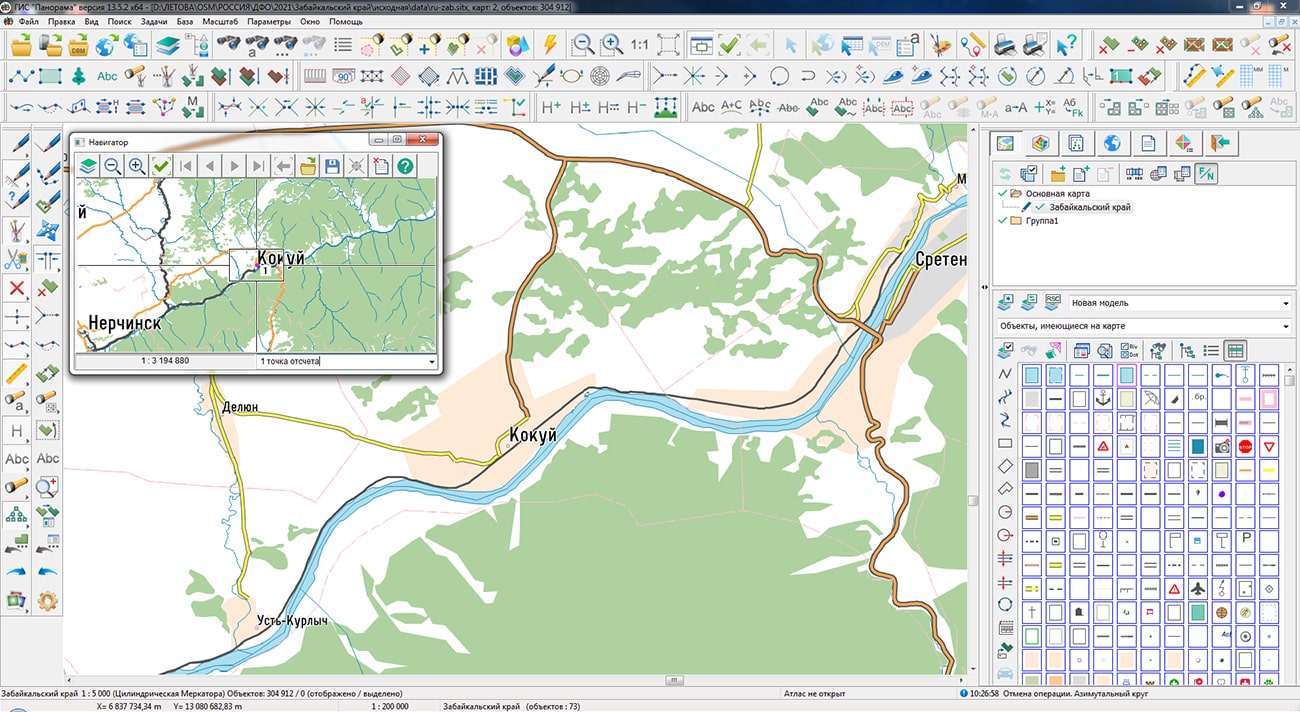
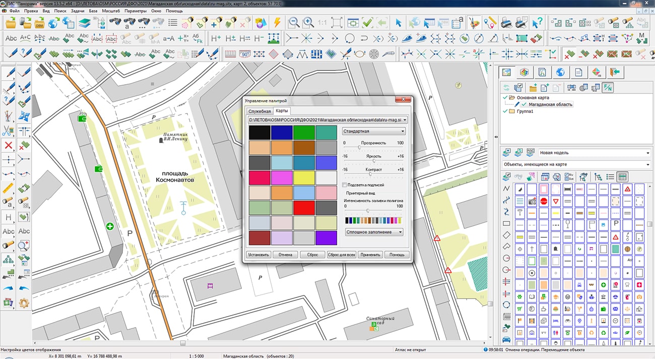
Specialists of KB "Panorama" prepared and placed on the geoportal the maps of Zabaykalsky Krai and the Magadan Oblast. The maps were formed using OpenStreetMap data, source data was obtained from website. To work with the maps, you can use the program or other software products of KB "Panorama".
The maps were led to the modernised classifier of large-scale plans of scale 1: 5 000 (map5000m.rsc) and were saved into a packed project (MPTZ). The MPTZ format project includes a digital map of the region's territory (country, subject of the federation, administrative region), a map of the administrative-territorial division of the region and a digital classifier. Publishing of updates in bank of spatial data is made by using the program of . Publishing contents of bank of spatial data on the geoportal and data access for downloading are implemented by means of .
Free maps on the basis of OpenStreetMap data are available for download on the page "Digital maps".


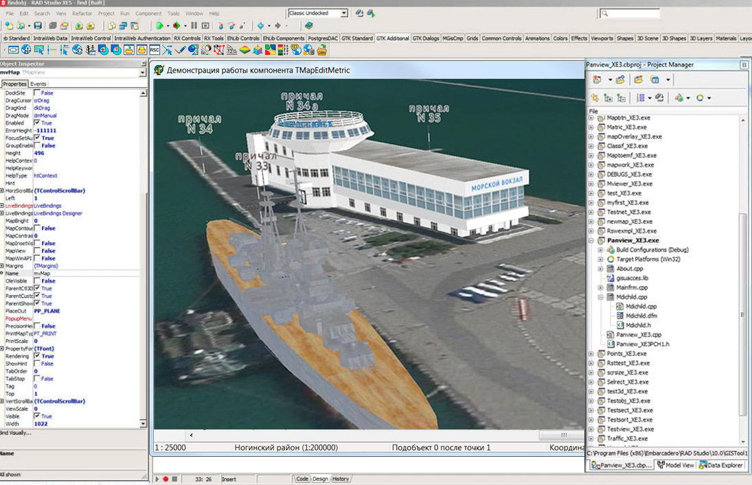
In KB "Panorama" the of version 13.2.1 has been developed for creating GIS-applications in the environment of C ++ Builder, Delphi Embarcadero. The new version expands the possibilities of the TMapEditMetric component, which allows the programmer to implement interactive creation and editing of metrics (coordinates) of map objects in his application. In addition to the available modes for creating objects and subobjects, moving of objects, adding, deleting and editing metric points and selecting an arbitrary point on the contour of an object, a mode for selecting metric points of an existing object to "capture" points of other map objects or nodes of a rectangular map grid has been added into the component. If the corresponding option is activated, when the mouse cursor moves over the map, objects are searched for in the immediate vicinity of the cursor and the current edited point is "pulled" to the nearest metric point of the found object. It is possible to "capture" both the "real" points of the nearest object - in this case, only the points recorded in the metric of the object are taken, and "virtual" points - in this case, the coordinate of the point closest to the cursor on the contour of the object is taken, which is not necessarily included in the metric of this object.
Into the TMapEditMetric component the method has been added allowing from the outside to set coordinates of a current edited point. This allows the programmer to implement additional control over process of interactive editing, complementing it, for example, with possibilities of positioning by pressing keys on the keyboard.
In the updated component of interactive editing, a whole set of events has been added that allow you to perform its processing when you select an object point, edit it or delete it. In this case, in the event handler, it is possible to correct the coordinates of the point being edited or to cancel the corresponding operation altogether. This makes it possible to implement additional logic in the application - for example, control and prohibition of object points falling into certain zones.
The TMapView and TMapScreen map display components have the ability to display a rectangular grid and control its parameters.
The GIS ToolKit consists of a set of visual components (supplied in source code) and API functions of the GIS core for direct access to spatial data. The toolkit is intended for the development of client-server and desktop 32-bit and 64-bit applications that require processing and visualization of spatial data. Spatial data can be located both at the workplace (direct access to data) and in a local network or the Internet (components of access to the or data exchange using international protocols are used).
The new version of the program is available for download on the page.


Ph.: +7 (495) 739-0245, +7 (925) 221-1603
www.gisinfo.ru | panorama@gisinfo.ru
105005, Russia, Moscow, Baumanskaya Street 7, building 1, office 229 (m. Baumanskaya)
Copyright © Panorama Group 1991 - 2024


 Mobile version
 Full version