Copyright © Panorama Group 1991 - 2024

In KB "Panorama" the versions 6.1 has been developed for operating systems Astra Linux, CentOS, Ubuntu, MS Windows. The new version adds the ability to display a 3D map with additional parameters of the orientation of the terrain model and the coordinates of the observation point. The parameters allow you to convert the three-dimensional map into a form that is convenient for perception already at the start of the mode. are generated using a database of terrain models in DB3D format, photorealistic three-dimensional models of unlimited size (TLS, OC3) are used, spatial data is imported from other exchange formats. The projects the and have been updated. Projects provide access to an infrastructure of the spatial data deployed on the web-server in OC Ubuntu. The tools of searching for map objects have been expanded. The ability to select objects, taking into account their visibility at the current scale of the map display, has been implemented. Map editor, administration module have been updated.
In the new version the toolkit for developing Web applications the has been improved, which expands the capabilities of GIS WebServer SE and can be integrated into other information systems. Access to data (images, vector maps and information about the terrain) is provided by Web services according to the generally accepted OGC protocols and ISO standards. Various types of elevation data are used as a digital elevation model: matrixes (in SRTM, GeoTIFF, IMG, MTW formats), TIN models, point clouds, and others.
can be as a source of spatial data. It provides collection, storage, search and issuance of spatial data in exchange formats, a displaying the state of the data bank in the form of maps-schemes, automated generation and updating of geo-covers.
GIS WebServer SE is used in the construction of closed corporate systems to ensure the protection of data that are classified or trade secrets. GIS WebServer SE is certified for level 2 of the absence of undeclared possibilities. The new version of the program expands the possibilities of the application when solving problems of analysis, management and long-term planning of the development of territories. GIS WebServer SE is implemented using the GIS WebToolKit SE, which can be used in development tools that use JavaScript.
The new version of the program is available on the website in the section.


Specialists of KB "Panorama" prepared and placed on the geoportal maps of Tyva Republic and the Republic of Khakassia. The maps were formed using OpenStreetMap data, source data was obtained from website. To work with the maps, you can use the program or other software products of KB "Panorama".
The maps were led to the modernised classifier of large-scale plans of scale 1: 5 000 () and were saved into a packed project (MPTZ). The MPTZ format project includes a digital map of the region's territory (country, subject of the federation, administrative region), a map of the administrative-territorial division of the region and a digital classifier. Publishing of updates in bank of spatial data is made by using the program of . Publishing contents of bank of spatial data on the geoportal and data access for downloading are implemented by means of .
Free maps on the basis of OpenStreetMap data are available for download on the page "Digital maps".


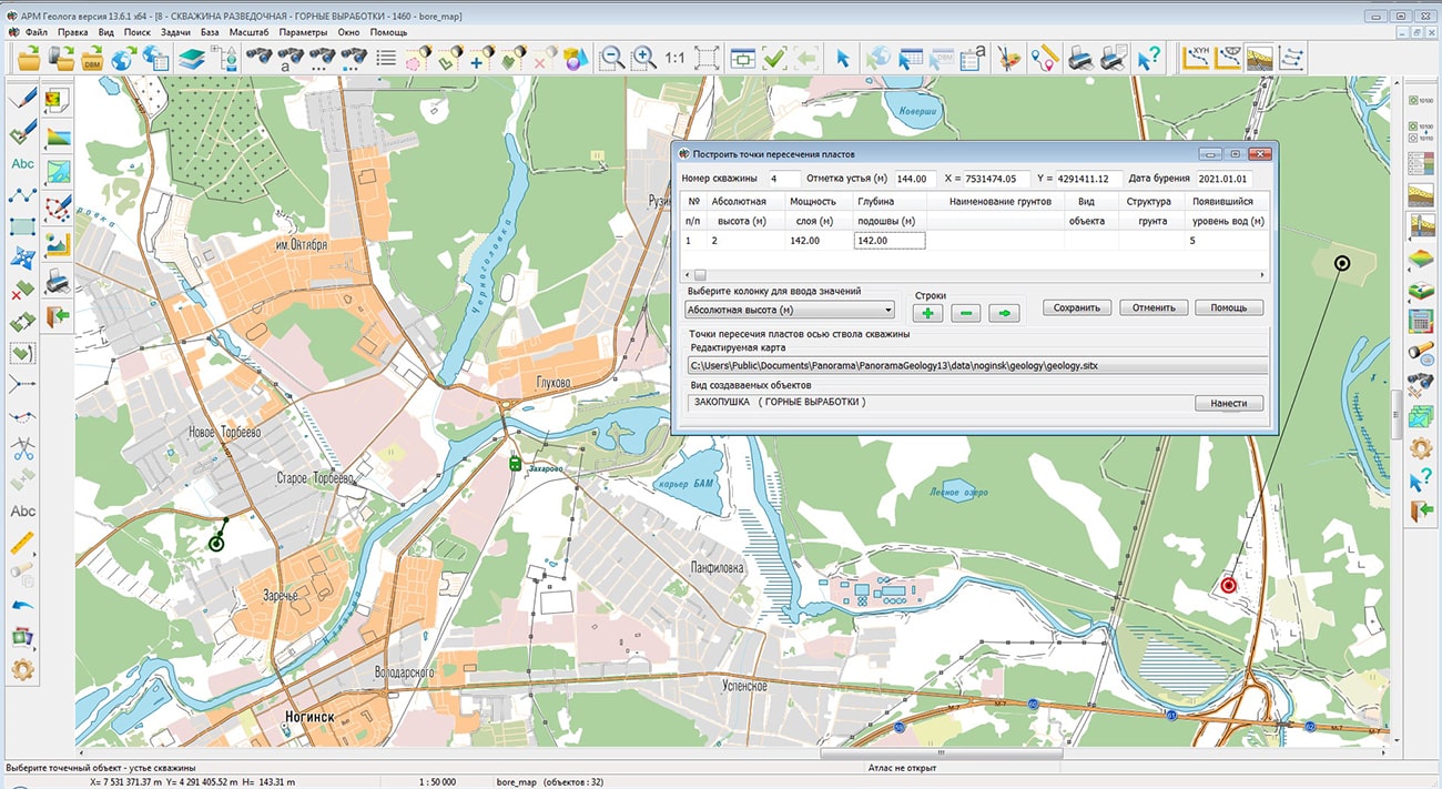
In KB "Panorama" the "Workstation of geologist" version 13.6.1 has been developed. "Workstation of geologist" includes the necessary components for processing and analysis of the terrain, geological structure, soil properties, hydrogeological conditions and geological processes. In the new version of the program the has been updated. The following modes have been implemented: "Build the well axis by coordinates", "Build the well axis by inclinometry", "Build of intersection layers", "Horizontal and vertical projection of the well axis". New modes are grouped into a separate panel "Well calculations", they are intended for processing and analysis of three-dimensional data on the axis of the well, including processing of inclinometry measurements. The mode "Horizontal and vertical projection of the well axis" provides creation of inclinogram - scheme of a projection of well onto horizontal and vertical planes. This mode allows you to analyze the spatial location of several adjacent wells.
The included into the "Workstation of a geologist" is intended for an estimation of water filling of a given a given at changing the level of rising of water, and also obtaining the graphic documents with results of modelling. Geological and hydrological tasks use matrix data to analyze relief and terrain conditions. The matrix of heights is intended for relief modelling. The matrix of layers provides modelling of geological layers. The matrix of qualities is used to model and analyze various characteristics: the level of groundwater occurrence, the type of soil cover, the depth of the reservoir, the coefficient of mechanically mined soil, the level of flood waters, and much more. In the new version of the program the mode "Matrix calculator" has been added, intended for execution of operations of maps algebra. Algebra of maps - operations during performing of which, on the basis of one or several source matrixes, the new matrix is created, and values of cells of this matrix depend on values of cells of the source matrixes having identical coordinates. The use of this mode expands the possibilities for analyzing the results of engineering-geological and engineering-hydrological surveys of the area and assessing the hydrogeological conditions taken into account in the designing, construction and operation of real estate objects.
The new version of the program is available on the website in the section.


Specialists of KB "Panorama" have updated and placed maps of Transcaucasia on the geoportal . Maps were formed according to OpenStreetMap data, source data obtained from website. To work with the map, you can use the program or other software products of KB "Panorama".
The maps were led to the modernised classifier of large-scale plans of scale 1: 5 000 (map5000m.rsc). Publishing of updates in bank of spatial data is made by using the program of . Publishing contents of bank of spatial data on the geoportal and data access for downloading are implemented by means of GIS WebServer SE.
Free maps on the basis of OpenStreetMap data are available for download on the page "Digital maps".


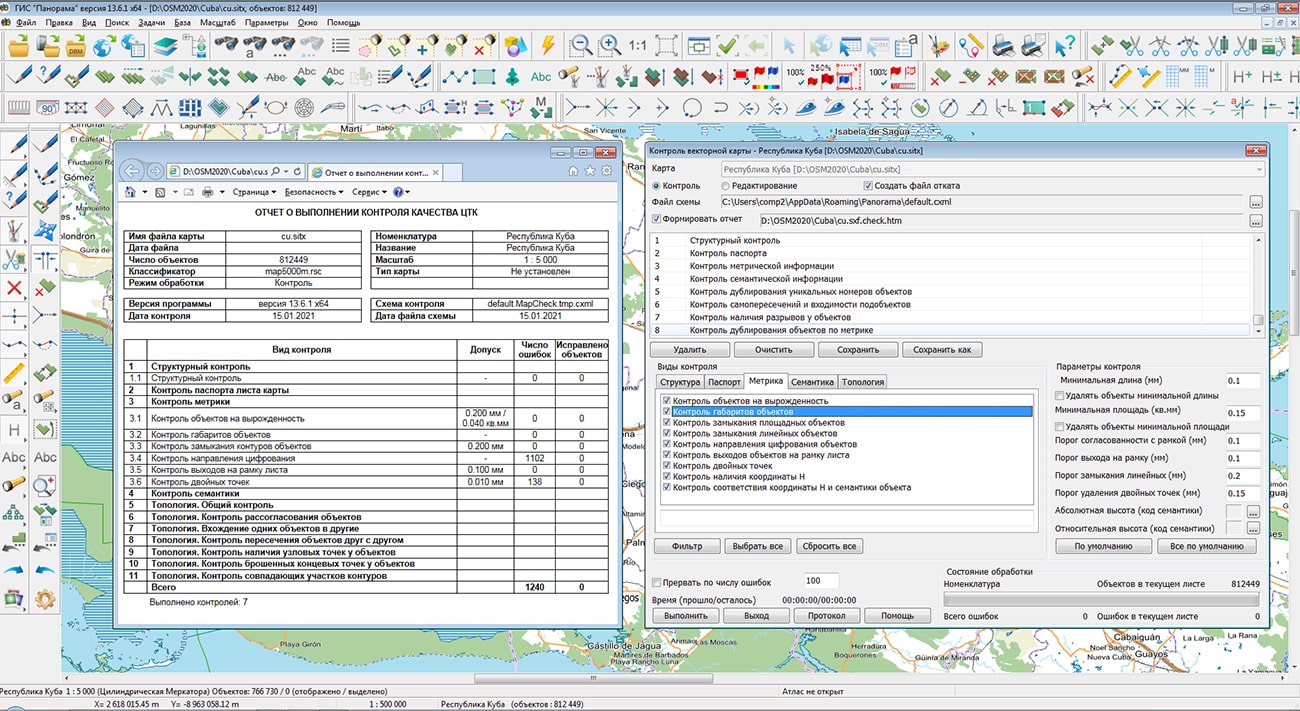
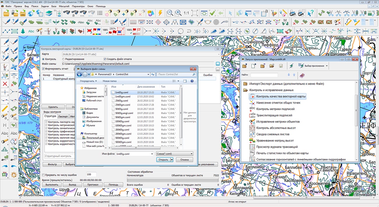
In KB "Panorama" the Complex of the automated checking the quality and correction of maps version 7.1 has been developed. In the new version the procedures of checking the quality of a digital map have been improved. Control of double points of the objects metrics was updated. When performing control in edit mode, double points are filtered taking into account topological links with neighboring objects on the map sheet. Neighboring objects with common points are filtered at the same time. Endpoints are not filtered. Control of repetition of values of unique semantics on sheet has been added.
A new mode "Control of values by symbol table" has been added into the control of objects semantics. This control allows you to find Latin characters in the values of the selected symbolic semantics and replace Latin characters with Cyrillic characters. This mode is relevant for characters that have the same image in Latin and Cyrillic, for example: K, A, M, E, P, T, O, H and others. Correction of the text semantics is necessary for the correct operation of tasks of search by the value of symbolic semantics, for example: by the name of the city, street, surname.
There is added a control over the direction of digitizing multipolygons. Control of report of adjacent sheets has been improved. The check for the digitizing direction of linear objects going on the sheet frame has been implemented. Objects with the direction of digitization "Predefined" (linear rivers), "Lower right" (horizontals) are checked.
The complex of automated checking the quality and correction of digital maps is designed to obtain a single digital map from the original digital maps in the SXF format, created according to different classifiers. The complex consists of a program of checking and correcting the DTM in SXF format, a utility for control of coordination of adjacent DTM sheets, a subroutine for combining adjacent DTM sheets and a procedure for analyzing the correspondence of the object content of maps and classifiers.
The new version of the program is available for download in the Download section.


Ph.: +7 (495) 739-0245, +7 (925) 221-1603
www.gisinfo.ru | panorama@gisinfo.ru
105005, Russia, Moscow, Baumanskaya Street 7, building 1, office 229 (m. Baumanskaya)
Copyright © Panorama Group 1991 - 2024


 Mobile version
 Full version