Copyright © Panorama Group 1991 - 2024

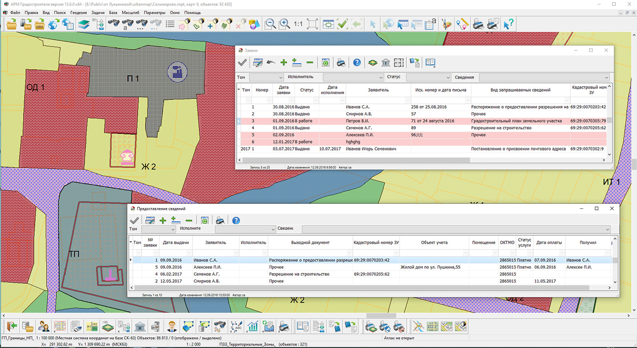
In KB "Panorama" the version 13.6 has been developed. The new version introduces changes into the registers and reference books of the database of documents, materials and urban planning information. Registers of special data are maintained in order to streamline information by sections of the state ISOGD (Information System Designed for City Planning). To earlier existing registers: "Land plots", "Objects of capital construction", "Engineering communications", there are added the new thematic registers: "Borders of engineering researches", "Artificial land plots", "Zones with special conditions of use of territory", "Ground and underground communications", "Specially protected natural territories", "Forest areas" and "Servitudes". Between registers the spatially-logic links providing fast and evident search of the necessary information have been established.
To record incoming information, documents and materials received for placement into the state ISOGD, the "Account register" has been developed. Files related to information, documents, materials or their scanned copies are attached to registry accounts. To systematize and conveniently record information, specialized reference books and classifiers have been developed in accordance with the Decree of the Government of the Russian Federation №279 dated March 13, 2020 "On information support for urban planning activities."
Urban planning information, placed in specialized sections of State ISOGD, is ordered by administrative-territorial division (ATD). In addition to binding to ATD, documents, materials and information placed in the database have a spatial reference due to spatial-logical links with the objects of the digital map. There is provided an automatic filling of the register of land plots with files of documents and materials by means of the "Streaming documents loading" mode.
Description of the contours of boundaries and attributive information of land plots and real estate objects is formed on the basis of electronic XML documents from the Unified State Register of Real Estate. For up-to-date data schemas, the mode "Reading the cadastral plan of the territory and updating the map" is used, and for outdated information - the mode "Create objects from the XML file of the real estate cadastre".
The new version of the program is available on the website in the Download section.


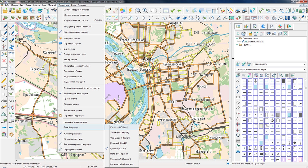
The specialists of KB "Panorama" prepared and placed on the geoportal a map of the Omsk region. The map was formed using OpenStreetMap data, source data was obtained from Geofabrik website. To work with the map, you can use the program or other software products of KB "Panorama".
The map was led to the modernised classifier of large-scale plans of scale 1: 5 000 (map5000m.rsc) and was saved into a packed project (mptz). The MPTZ format project includes a digital map of the region's territory (country, subject of the federation, administrative region), a map of the administrative-territorial division of the region and a digital classifier. Publishing of updates in bank of spatial data is made by using the program of . Publishing contents of bank of spatial data on the geoportal and data access for downloading are implemented by means of .
Free maps on the basis of OpenStreetMap data are available for download on the page "Digital maps".


In KB "Panorama" the "Workstation of cadastral engineer" version 13.6.0 has been developed. The new version has improved the tools of information interaction with the Unified State Register of Real Estate. The "Search by cadastral number or address" mode has been updated. Ability has been added to select a search source by the map or by generating queries in the EGRN. At a positive reply on request in EGRN, the "Information from the State Real Estate Cadastre" dialog will be displayed. For positioning the map to the location of the cadastral object, geocoding by address is automatically performed. For direct address geocoding by means of external services, it is necessary to specify an API-key of access to service.
The dialog "Information from the State Real Estate Cadastre" has been improved, support for the API functions of the apirosreestr.ru service for accessing data has been implemented. The mode provides sending requests to the EGRN to obtain information about the cadastral objects available at the specified point on the map. The obtained information is displayed as a list of cadastral numbers on the corresponding bookmarks of the dialog. When a specific cadastral number of an object is selected from the list, a request is generated to obtain public cadastral information about a quarter, land plot or real estate object. The received information is displayed in the dialog. The "Premises" bookmark has been added to display information on premises, apartments and parking lots.
"Workstation of cadastral engineer" provides direct display and editing of arbitrary spatial databases in cartographic conventional symbols, including those created by other GIS, without additional third-party modules based on direct interaction with PostgreSQL and Oracle DBMS through SQL queries. In the new version, the tools for viewing and editing tables of attributes of spatial databases have been expanded. Modes are added: select/cancel linked objects, show records for selected objects, show information about a map object for the current record. In dialog the tools for convenient viewing the table with a large amount of data are added: customization of the order of displaying columns, change of their width, setting the visibility status of columns.
In the "Map Editor" task, the composition of the "Graphic Objects" panel has been expanded: modes have been added for controlling the color, scale, transparency of the conventional symbol of the object selected on the map. In the mode of editing common vertexes the function of capture of nodes of other objects ('K') has been added. In the mode of union of selected line objects, the option "Create polyline" has been added to combine the selected line objects into one object.
In the "Reading the cadastral plan of the territory and updating the map" mode, the algorithm for updating the data on the cadastral map has been changed. The speed of searching for existing objects on the updated cadastral map for their processing has been significantly increased.
In the dialogs "Land survey plan" and "Technical plan", the tools of obtaining an address from FIAS have been improved. There are added checks for individual geonyms in terms of mismatched values with the classifiers used in the EGRN. A check for type of settlement has been added for displaying the name into the necessary positions of dialogs, for a city into the "City" position, for all others into the "Settlement" position.
"Map print" dialog has been improved. Ability has been added to limit the display area of the map by the border of the selected areal or closed line object. In this case, you can set the degree of transparency of the map display outside the borders of the main contour of the object from 0 (source image) to 100% (completely filled). This mode is called through the context menu in the "Map print" dialog by pressing the "Select area by object" button.
The survey.v5.rsc classifier has been updated, intended for the cadastral map used in information interaction with the FSIS EGRN and in the preparation of cadastral documents. In the classifier the list of objects has been expanded, for which the semantics "Floor type" (code 1119) has been added, which is necessary for preparing technical plans for the creation and formation of real estate objects, parts of real estate objects, as well as technical plans for changing information about real estate objects and their parts.
The new version of the program is available on the website in the Download section.


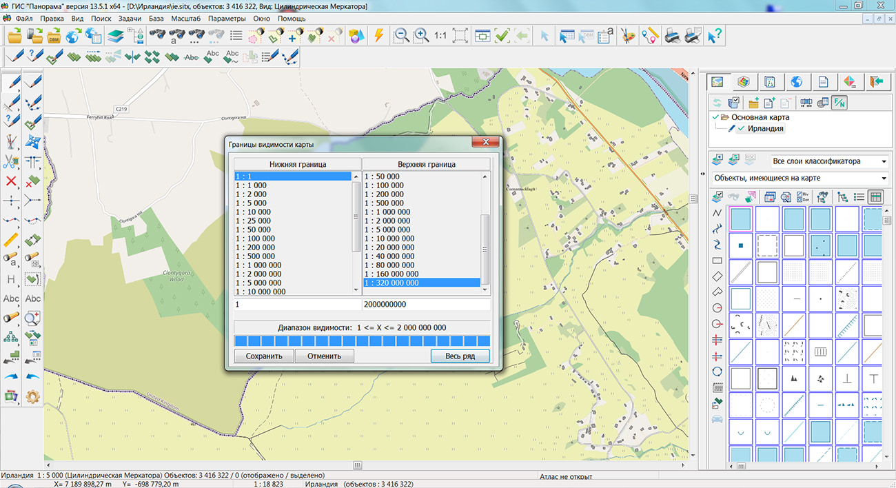
The geoportal has been supplemented with a map of Ireland, formed according to OpenStreetMap data. Source data obtained from Geofabrik website. To work with the map, you can use the program or other software products of KB "Panorama".
The map was led to the modernised classifier of large-scale plans of scale 1: 5 000 (map5000m.rsc). Publishing of updates in bank of spatial data is made by using the program of . Publishing contents of bank of spatial data on the geoportal and data access for downloading are implemented by means of .
Free maps on the basis of OpenStreetMap data are available for download on the page "Digital maps".


In KB the Panorama the "Workstation of Agronomist" version 13.6 has been developed. The new version of the program is focused on solving the problems of creating and applied use of digital maps of agricultural land in conjunction with the agrarian base. The industry classifier is designed to create digital maps. Drawing and editing of the contours of objects of industrial designation is carried out using the built-in "Map Editor". The "Passport of field" task ensures the maintenance of data on business entities, crop rotations, phytosanitary conditions, agrophysical and agrochemical properties of agricultural land contours. The new version of the program implements localization into English of all modes intended for the creation and editing of cartographic and attributive information about agricultural land, including the processing of field survey materials and the results of laboratory analysis of agrochemical indicators of arable land.
In the task "Lists of objects" when searching for intersection and overlap of objects, the "Matching contours" mode has been added. The mode carries out search for the contours of agricultural land at which the external and internal contours coincide with other farmland or other objects (cadastre, land management, forest management and others).
To update the data of the electronic farmland map, the "Collecting field measurements" mode is used. When carrying out field work, an agronomist can take with him a mobile device (tablet), on which the "Workstation of agronomist" software is loaded with a working map. On this map, you can immediately clarify the boundaries of the working areas of the fields, create new areas, and also enter the semantic characteristics of the fields for various soil measurements. In the "Update semantics" mode, a synchronization of the attributes of agricultural land, recorded in the semantics of the map during autonomous work in the field, with the information stored in the agrarian database is provided.
"Map print" dialog has been improved. Ability has been added to limit the display area of the map by the border of the selected areal or closed line object. In this case, you can set the degree of transparency of the map display outside the borders of the main contour of the object from 0 (source image) to 100% (completely filled). This mode is called through the context menu in the "Map print" dialog by pressing the "Select area by object" button.
"Workstation of agronomist" supports the processing and analysis of data of satellite monitoring. Interaction with an external service of Earth's remote sensing data is provided to obtain matrices of vegetation indices, maps of zones of inhomogeneities of fields and a time series of averaged values of vegetation indices. The resulting maps and matrices are used to analyze the amount of biomass in order to make management decisions in agriculture. The download source is the Geosys web service.
The data on the contours of agricultural land are represented by vector maps, matrixes of relief heights, matrixes of vegetation indices, maps of heterogeneities, thematic maps and matrixes. The hierarchical structure of the project of agrarian data can include unlimited number of maps and matrixes. To speed up the opening and first display of maps, the formation of a binary tree of territorial distribution of objects for each map sheet has been added. When the map is opened, the object tree is read, which accelerates the first display by 5-15 times (for a map with 2 million objects, the opening and first display is accelerated from 9-12 seconds to 1 second).
The display of DEMs has been improved, the color of the coverage point is calculated based on 16 adjacent heights using the bicubic interpolation method. The new method of obtaining the color of an element allows you to eliminate the discreteness of the display of the matrix and the light-shadow relief mask. To display DEMs with smoothing, enable the main menu item "Options" - "Display matrix with smoothing".
"Workstation of agronomist" provides information exchange with external programs. For this, scheme of exchange in the form of XML format files is provided. The joint functioning of the "Workstation of agronomist" and information and control systems on the 1C platform, configuration "AgroHolding" and Management of an agricultural enterprise is supported. The exchange scheme is two-way, which allows import and export of data.
All modes of the "Workstation of agronomist" work with the agrarian database in the "Panorama AGRO" structure and support the placement of data on the GIS "Server" to ensure collective multi-user access. There is added the ability to specify the environment variable instead of the host name in the name of data opened from the GIS Server. It allows to customize MPT/MPTZ projects of data (having replaced a server name with an environment variable) which can, if necessary, be transferred into another network environment (for example, from a test platform onto production platform) without reconfiguring the addresses of the data being opened. When saving MPT/MPTZ projects, the server name is automatically replaced with an environment variable if it is set for the given server name.
The new version of the program is available for download in the Download section.


Ph.: +7 (495) 739-0245, +7 (925) 221-1603
www.gisinfo.ru | panorama@gisinfo.ru
105005, Russia, Moscow, Baumanskaya Street 7, building 1, office 229 (m. Baumanskaya)
Copyright © Panorama Group 1991 - 2024


 Mobile version
 Full version