Copyright © Panorama Group 1991 - 2024

In KB "Panorama" the version 9.3.6 has been developed for OS Astra Linux SE (release "Smolensk") and CentOS. In the new version the possibility of transfering event log messages into the operating system has been implemented. Logging events in any service is one of the essential tools for a system administrator. With its help, he will be able to see the actions of users when working with maps and documents (connecting, creating, opening), as well as analyze configuration errors. The new version provides users with the ability to transfer the log into a service with support for the SysLog protocol. This allows you to use the full range of powerful software tools for storing and analyzing event logs.
Syslog is a full featured event logging system written by Eric Allman. It serves two important functions: it frees programmers from the tedious mechanical work of maintaining log files, and puts the management of the log files into the hands of administrators. Before the advent of the Syslog system, each program chose its own event logging scheme, and system administrators did not have the ability to control what information was stored and where exactly. Syslog is highly flexible. It allows to sort messages by sources and level of importance and to send them to various destinations: log files, user terminals, and even other computers. One of the most valuable features of this system is its ability to centralize the procedure of registration of events on the network.
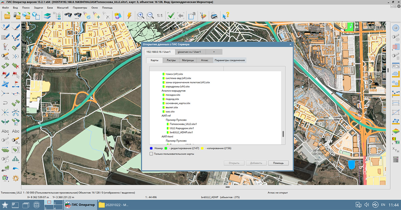
GIS Server provides remote access to vector maps, remote sensing data, matrices, documents, spatial databases and pyramids of tiles in the formats GPKG, BIR, Mbtiles. GIS Server supports work with spatial databases under control of PostgreSQL and Oracle DBMS, which support the ability to access spatial data in accordance with the OGC 06-103r4 standard: "OpenGIS Implementation Standard for Geographic information - Simple feature access - Part 1: Common architecture".
New versions of programs are available for download in the section.


In KB "Panorama" the GIS Panorama Mini version 13.2.0 has been developed for OS Astra Linux SE (release "Smolensk") in Russian and English. The program is built on a multi-platform multi-threaded core for Linux, QNX, Android, MS Windows with support for Intel/AMD, Elbrus, ARM, PowerPC, SPARC, MIPS and others. To improve the reliability of the software, numerous automated functional tests have been developed, the code has been optimized using the analyzers of text and performance evaluation on a multi-core architecture. The program processes modern spatial data formats: data from geoportals, pyramids of tiles BIR, GPKG, multiscale packed maps MAPZ, MPTZ and others.
GIS Panorama Mini supports import of data from the most popular formats: vector maps SXF, TXF, DIR, SHP (Shapefile), DXF (AutoCAD), OGC GML (XML), KML (Google), DXF, S57 and others; the raster data (RSW, BMP, JPEG, PNG, GeoTIFF, TIFF); matrixes of heights and matrixes of qualities MTW, MTQ, GRD, SRTM, GeoTIFF; geological matrixes of layers, TIN-models and the data of laser scanning (a cloud of points in MTD format); navigation data GPX;aeronautical data ARINC-424.
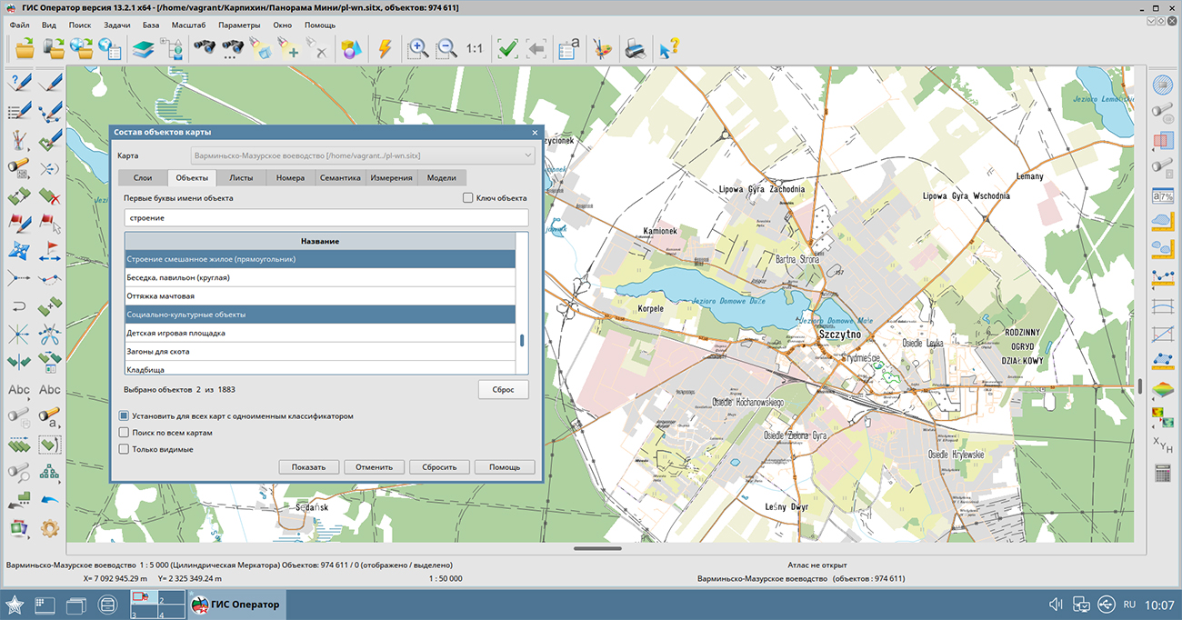
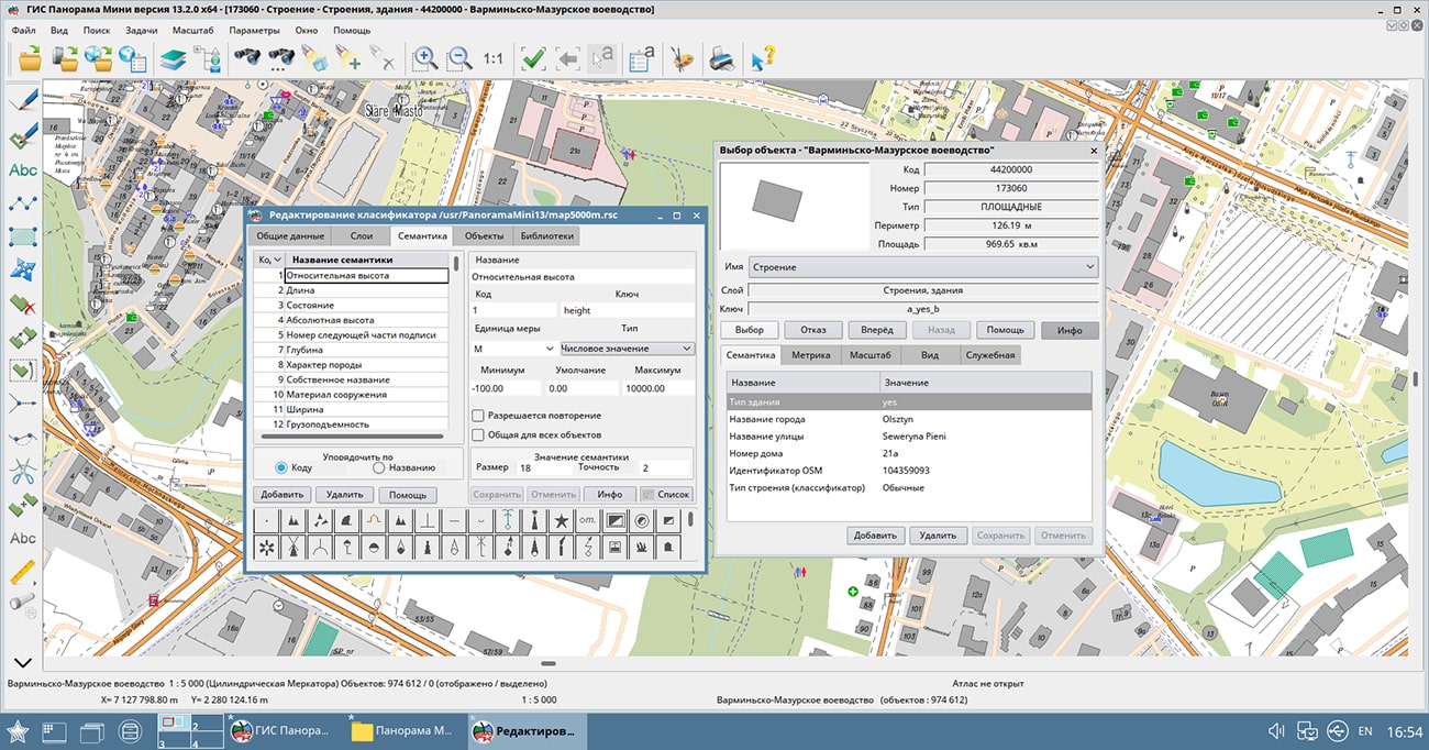
The software allows to create new maps of MAP, SIT, SITX formats with automatic filling of parameters by EPSG code or from the list of parameters in XML format. A created or imported map can be modified by the user with the help of "Map Editor". The "Map Editor" task provides the following possibilities: creation of simple objects and objects with subobjects; creation of objects according to the type selected from the panel of breadboard models of created objects; creating, deleting and moving the points of the object contour; moving and rotating objects; drawing simple lines and polygons; input of texts of signatures and values of attributes in UNICODE. Search for objects on the map is carried out according to geometric and semantic characteristics.
GIS Panorama Mini allows you to combine vector, raster and matrix data in different projections. Thus, projection transformation will be executed on the fly. The multiuser access to the remote data with control of access by means of connection to the is supported.
Connections to popular geoportals are supported, which allow displaying user maps over images received from the sites OpenStreetMap (Map), Yandex (Sputnik), Yandex (Map), Rosreestr, Kosmosnimki, Monitoring of aircraft movement and others. The list of geoportals is constantly expanding and can be supplemented by system users. In addition, GIS Panorama Mini can be used to connect to arbitrary servers using the OGC WMS and OGC WFS protocols (for example, based on ).
The user can print open data to various output devices with customizable print parameters. Vector data can be exported into exchange formats SXF, TXF, DIR, SHP (Shapefile), OGC GML (XML) S57, ARINC-424 and others; raster data - into RSW, BMP, JPEG, PNG, TIFF formats.
The new version of the program is available for download in the section.


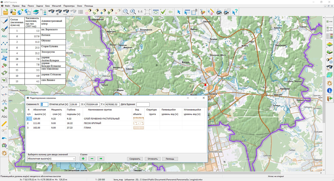
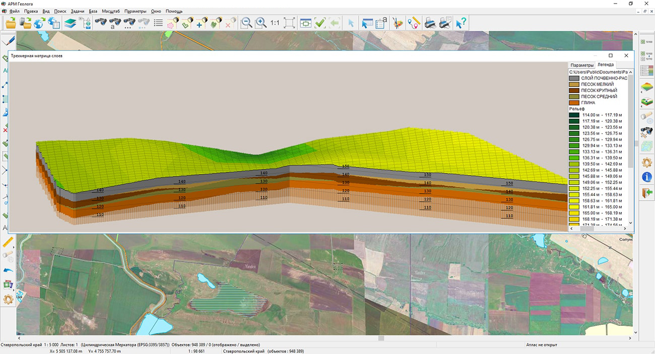
In KB "Panorama" the "Workstation of geologist" version 13.5.2 has been developed. "Workstation of geologist" has been created on base of and the and provides processing of results engineering and geological researches in order to obtain the necessary data for the designing, construction and operation of real estate. The program contains the necessary components for the analysis of engineering-geological conditions, including relief, geological structure, soil properties, hydrogeological conditions, hazardous geological processes.
"Panorama" software meets the requirements of regulatory documents SP 47.133330.2012 (SNiP 11-02-96), SP 126.13330.2012 (SNiP 3.01.03.-84), GOST 21.508-93, GOST R ISO 9127-94, GOST R ISO / IEC 12119-2000, which is confirmed by a certificate of compliance of software products in construction with the requirements of the State Construction Committee of Russia "On certification of software". To represent conventional special symbols on the map, reflecting engineering and geological conditions, a graphic library has been developed that corresponds to GOST 21.302-96.
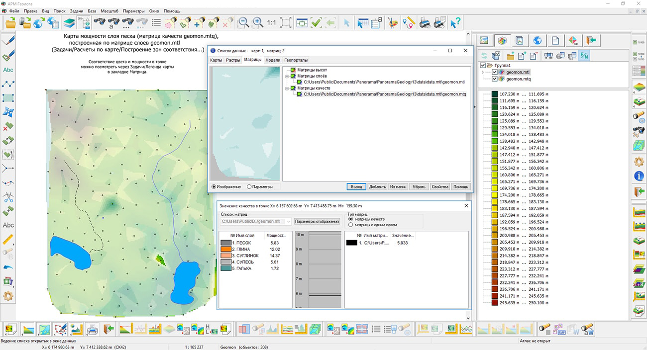
Integral part of the engineering-geological report are the engineering-geological columns and cuts. On the basis of these documents, together with the physical and mechanical properties of soils, the main design decisions are made (choice of the type of foundation, preparation of the basis and the need for reinforcement). "Workstation of geologist" provides input of data from the journal of engineering-geological researches, conducting a map of points of studying the geological structure (selection of monoliths for laboratory researches), creation of matrixes of a relief, matrixes of geological layers and matrixes of groundwater level. The constructed matrixes are used for a comprehensive analysis of engineering-geological conditions by means of three-dimensional visualization and automatic creation of columns at points specified by the operator or cuts along a specified line.
For calculations and analysis the coordinate description of objects is used. "Workstation of geologist" supports the 2nd, 3rd and 4th description of the metrics of objects. If the third coordinate always determines the height, then the fourth coordinate can be interpreted in different ways, depending on the task being solved. For example, when importing navigation data in GPX format, a linear object (track) with a four-dimensional metric (latitude, longitude, altitude, time) is formed on the map. And when processing navigation data in the NMEA-0183 format, a linear object with a four-dimensional metric (latitude, longitude, altitude, speed) is formed on the map. To display linear objects with a four-dimensional metric, the program uses programmable conventional symbols, where the fourth dimension can be displayed in the color of a line segment, taking into account the value falling within the specified range or using another algorithm.
The new version of the program is available on the website in the Download section.

In KB "Panorama" the has been developed. In the new version, the task of connecting geoportals for viewing information about objects at a given point of the image has been improved. If several layers from different geoportals are open, then the request is made to the current layer specified in the dialog. Information about objects is requested by the geodetic coordinates of a point, is transmitted and displayed in the form of an html page, the content of which depends on the selected geoportal. Support of geoportal via WFS protocol was improved. When forming a cartographic representation of layers, it is possible dynamically to create a classifier (RSC) according to the requested xsd-scheme, taking into account the composition of layers, objects and their attributes. In accordance with the list of layers selected by the operator, objects containing geometry and semantics (attributes) are put on the map. For the convenience of selecting layers, a search by name has been added in the dialog of connecting WFS geoportals.
In the task, the modes of intersection search have been improved. The mode "Crossing and touch" has been added which carries out searches for pairs of objects which are crossed or touched. The "Crossing" mode has been changed - it searches for pairs of objects that, when intersected, form the inner and outer parts (relative to a closed contour).
In the "Undo operation" dialog of the task, the possibilities of filtering transaction log records have been expanded. When the option Operations with selected number is enabled, the window for entering the object number becomes available. The transaction tree is refilled with those records in which the specified object participated.
The task has been improved. The "Signature" mode has been added into the toolbar. The new mode allows you to create a signature on the raster image with the pen color of any font installed in the system.
The task has been improved. On the "Map" bookmark the information line "Parameters" has been added in which the number of sheets and objects is indicated. On bookmarks "Rasters", "Matrixes" in parametres there is displayed the information on the permission of editing, copying and printing, a measurement unit of a matrix and other data.
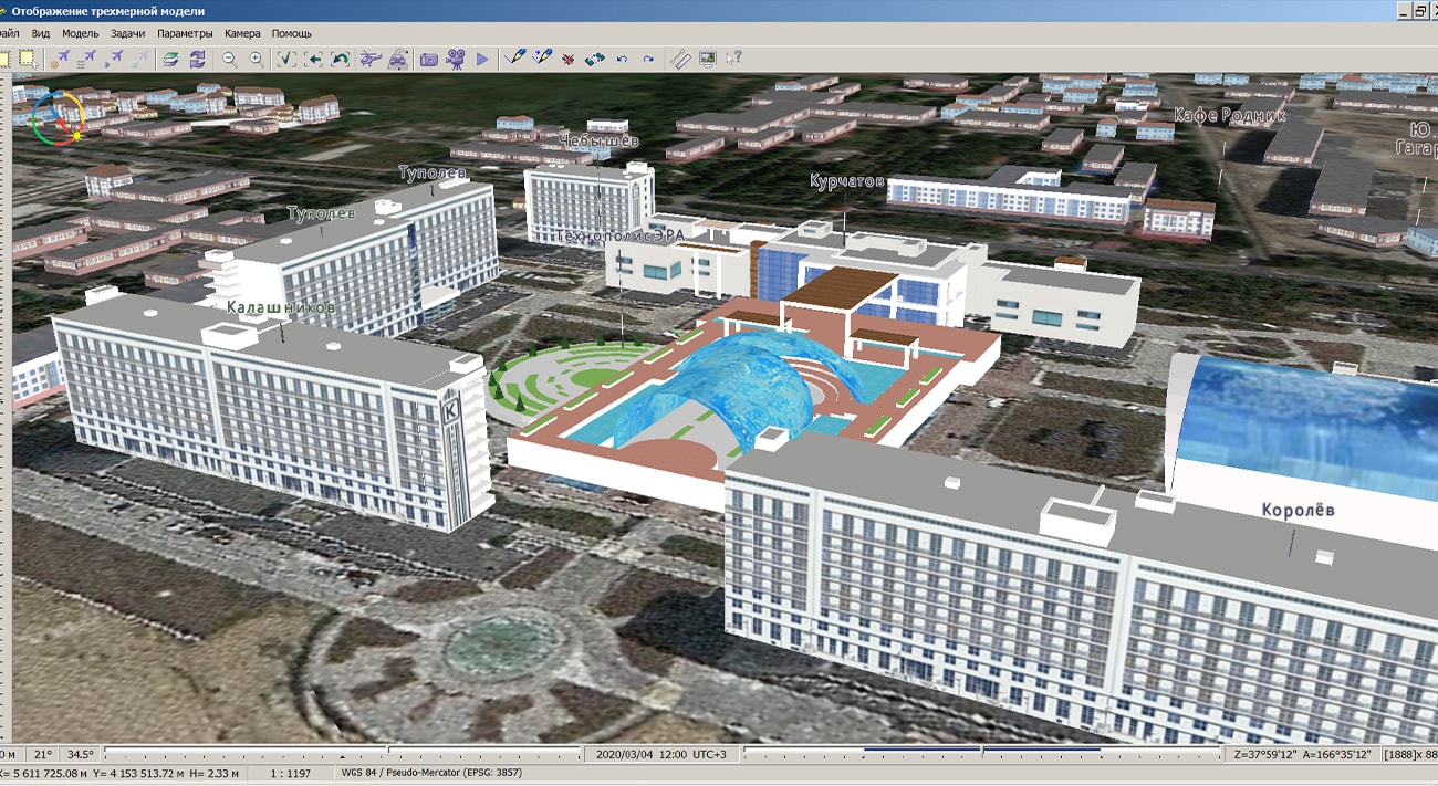
In the task, the mode of loading models from Collada (DAE) and OBJ formats into the DB3D database of three-dimensional tiles has been supplemented. To automate the input of the parameters of the coordinate system and an anchor point of the loaded model, the ability has been added to process the metadata XML-file, which is created by the manufacturer of the original 3D model. The choice of the metadata file is performed by clicking the "From metadata" button in the "Model geographic location coordinates" section of the converter interface.
In the task "Import files of waypoints, routes, tracks OziExplorer" there is added a saving into the metric of the object of the fourth dimension - date and time. The time characteristic is entered into the M-dimension in double format. The date and time of the fixation of the point coordinates are read from the corresponding fields of the waypoint files (.wpt) and tracklog files (.plt) of OziExplorer.
In the tasks of importing files of waypoints, routes, tracks for OziExplorer and Magellan Explorist there is added a saving into the metric of the object of the fourth dimension - date and time. Data is read from the corresponding fields in the waypoint files and track log files. In the task a saving into the metric of object of the fourth dimension - date and time. When loading waypoints from the device to fill in the fourth dimension of the object stored on the map, the date and time of determining the coordinates are requested from the GPS\GLONASS receiver. When using the task in the "Almanac" mode (determining the coordinates of the location in real time), the system date and time of the computer are taken.
In the dialog the ability has been added to open a list of datasets selected with the mouse and the CTRL and SHIFT keys, or included into the selected nodes of any level. To work with large lists of open datasets, there is added a search for datasets in the tree by name when pressing CTRL+F.
For the task , the classifiers and templates of out-of-frame bordering have been improved. Topographic fonts have been added to the frm10000.rsc classifier. For scales 1: 200,000, 1: 500,000, 1: 1,000,000, the following objects have been corrected in the classifiers: frame lines, labels of geographic coordinates, labels of squares numbers. In templates of out-of-frame bordering (frm files) for scales from 1:10 000 to 1: 1 000 000, object codes for elements of bordering have been corrected, distances between the map frame and other elements of bordering have been clarified. In files 500000.frm, 1000000.frm the element "Security classification" has been added.
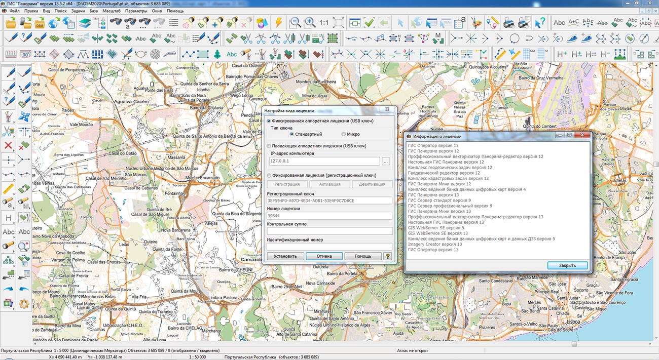
Dialog "Appear license" has been improved, it is intended for customizing the type of license and parameters for connecting to the network license. In the lower left corner of dialog the button "?" has been added, which causes a window "License Information". This window contains information about the type of the current license, its number, and also the list of software products available for this license.
The new version of the program is available for download in the section.
Technical support of GIS "Panorama" version 12 ends on December 1st, 2020.


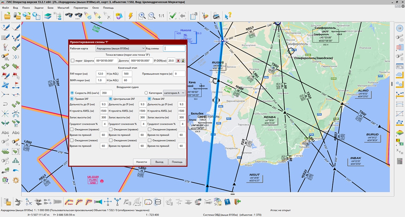
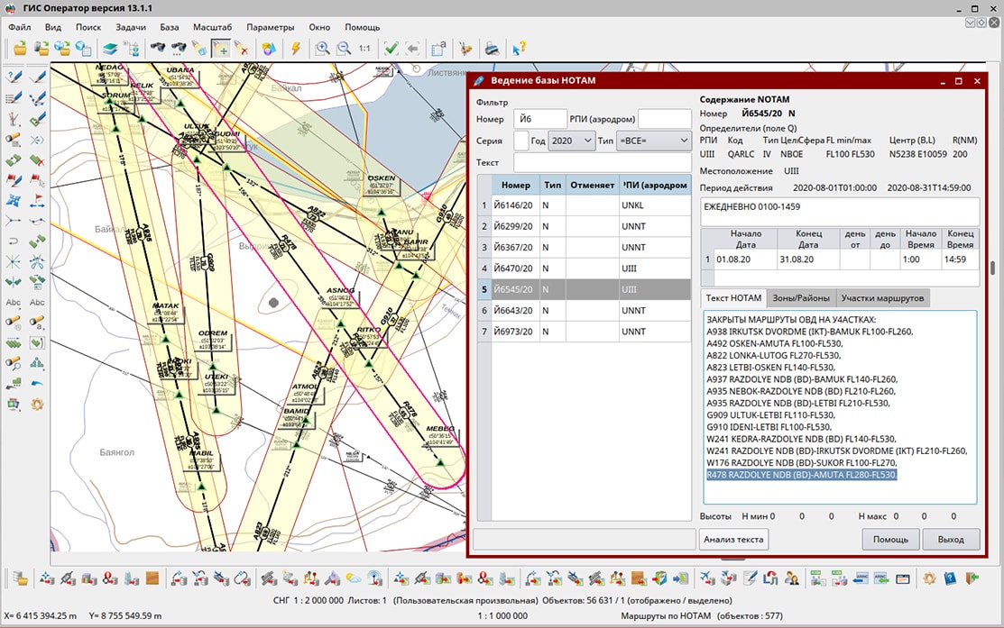
In KB "Panorama" the version 7.5 for the GIS "Operator" SE version 13, OS Astra Linux SE (release "Smolensk") has been developed. In the new version the possibility of processing and storage of aviation messages has been added. It will allow the user of air space to form bases of messages in the own interests. The complex implements the function of analysis and automatic processing of NOTAM messages. It allows to form and analyze the base of restrictions in air space in a graphic form. The use of the NOTAM database allows the operator to create maps of time restrictions, activated zones and closed sections of routes for a certain region in a given period of time. This will increase the efficiency of using the air navigation situation for flight operations. In the task "Flight procedures construction" the possibility has been added for forming the report of intermediate data of calculations of inverse schemes.
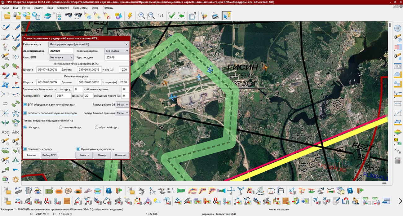
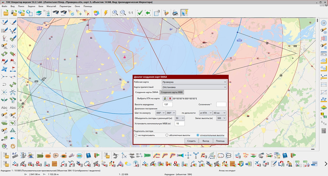
The complex of solving aeronautical tasks is intended for creating and maintaining a database of aeronautical information, formation of aeronautical maps, designing the flight routes for aircraft, exchanging data with other information systems. The program allows to carry out calculations of routes of flights, to analyze objects of airdrome and the surrounding area for their impact on air traffic safety.
The main source of aeronautical information is the aeronautical data base, created on the basis of the AICM (Aeronautical Information Conceptual Model) model, with additions for storing planning information and results of route design. The model is recommended by the international organization for air traffic planning and coordination "Eurocontrol".
The new version of the program is available for download on the Download page.


Ph.: +7 (495) 739-0245, +7 (925) 221-1603
www.gisinfo.ru | panorama@gisinfo.ru
105005, Russia, Moscow, Baumanskaya Street 7, building 1, office 229 (m. Baumanskaya)
Copyright © Panorama Group 1991 - 2024


 Mobile version
 Full version