Copyright © Panorama Group 1991 - 2024

The geoportal has been supplemented with a map of the Italian Republic, formed according to OpenStreetMap data. Source data obtained from website. The composition includes 5 territories: Islands, the Northeast, the Northwest, the Center and the South. To work with maps, you can use the program or other software products of KB "Panorama".
The map was led to the modernised classifier of large-scale plans of scale 1: 5 000 (map5000m.rsc). Publishing of updates in bank of spatial data is made by using the program of . Publishing contents of bank of spatial data on the geoportal and data access for downloading are implemented by means of .
Free maps on the basis of OpenStreetMap data are available for download on the page "Digital maps".


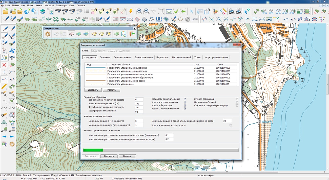
In KB "Panorama" the version 13.5.0 has been developed. In the new version of the program the complex of automated generalization of digital topographic maps of scales from 1: 25 000 to 1: 100 000 has been improved. In the mode of relief generalization, the quality of building the overlap matrix of contour lines has been improved, which is used to automatically generate additional contours. Additional contours are saved in areas free from overlapping the nearby contours. There is added an automatic increase in the area of small closed contour lines of hill tops that have elevation marks inside the areas bounded by small contours. In the mode of generalization of areal hydrography, the quality of automatic transformation of fragments of areal rivers into linear ones and the quality of matching new linear rivers with areal vegetation and soils have been improved.
Support was added of the multiscale objects having the several copies of a contour with different details of points. Additional contours are formed for smaller scales of display - 1/4 1/16, 1/64 from base scale of a map and are recorded into the object metrics together with the main contour. When compressing the map, those contours of objects that are closer to the current display scale will be automatically displayed. This speeds up the display of complex objects and makes the image of the terrain more visual. At any editing of the map and when performing calculations by the metric of the object, the main contour of the multiscale object is processed.
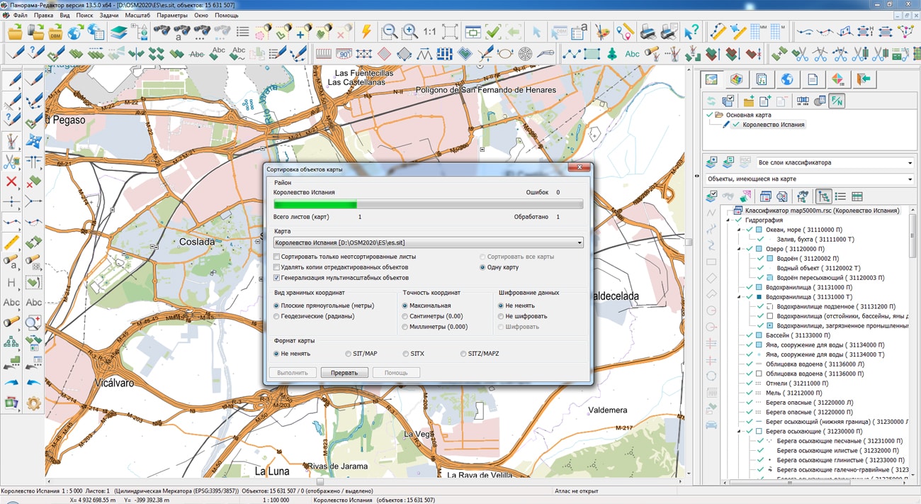
Multiscale objects are formed in the Map Sorting procedure. If for sorting the option of Generalization of multiscale objects has been selected, then for the objects of classifier RSC that have the Multiscale property, additional contours by a generalisation method will be built. Multiscale objects are one of the elements of a multiscale map that changes its view when changing the display scale. Application of multiscale maps in packed MPTZ project allows to reduce number of created scales (layers) of maps in system of storage, finishing and application of topographic and geodetic information.
Support has been added for drawing the titles linked with objects of a map, which at increase in the image of a map are pulled to the object. To do this, after entering the title text, you must place the cursor on the conditional binding point of the title and press CTRL + space, then move the cursor to the first point of the title placement and press the left mouse button. If the title is not horizontal then it is necessary to enter the second point to indicate the direction of the title placement. At increasing the image of a map the point of the title placement will be pulled to a binding point - the distance between them will be approximately in 1,5 - 2 times less, than at scaling the title without a binding.
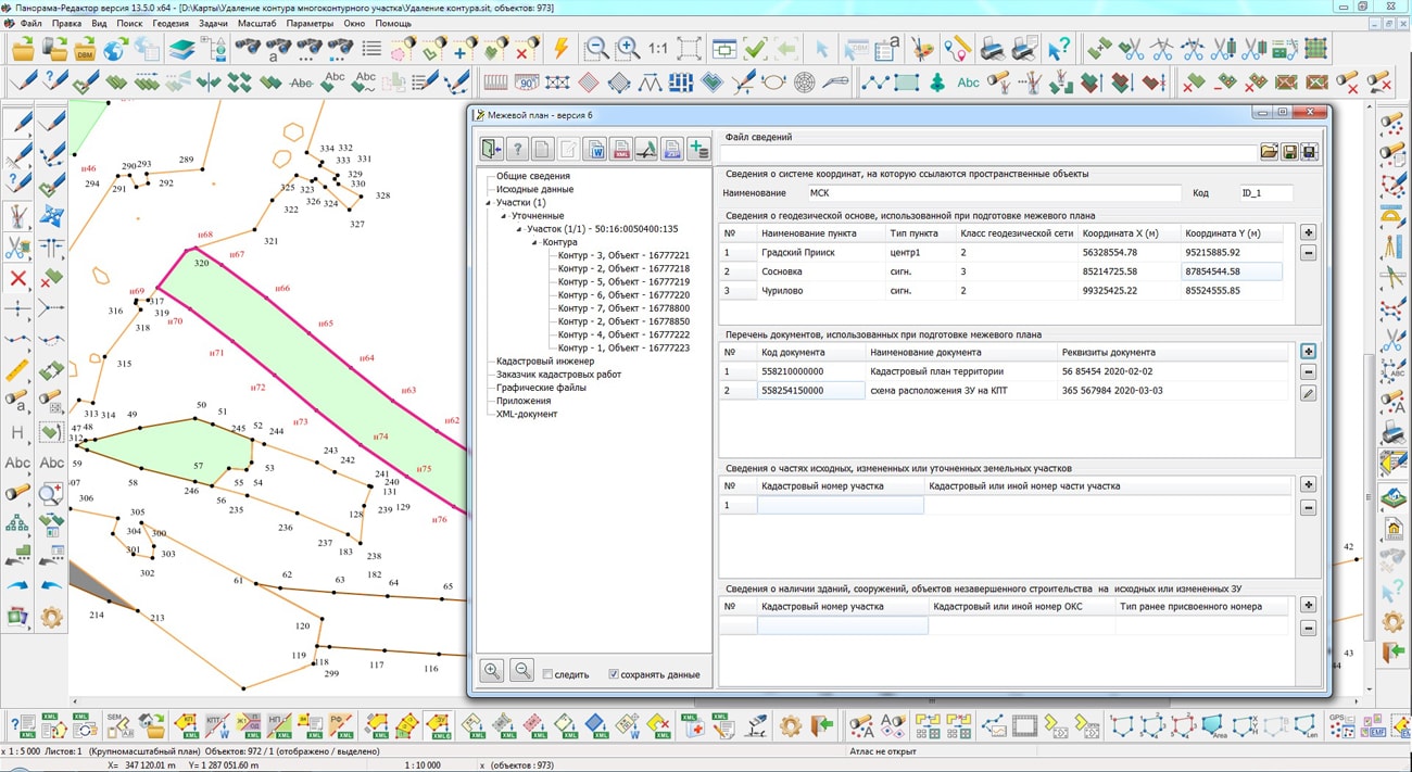
The block of geodesy and cadastral tasks has been improved. The mode "Reading the cadastral plan of the territory and updating the map" supports the XML-scheme extract_about_zones_v01 - an extract about zone. The list of conventional symbols for displaying cadastral objects characterizing the boundaries of a water object has been expanded. A linear object "WATER OBJECT ZONE" has been added into the survey.v5.rsc classifier to describe coastlines of reservoirs, large lakes, seas and other water objects, the border of which is not completely described, but in the form of separate fragments. The algorithm for reading spatial data for discrete cadastral objects has been updated. If there is information about the radius, the object of real estate is created a point one based on the coordinates of the center. In this case, the radius value is written into the semantics of the object. Collective use of "Base of cadastral works" of SQLite format was implemented, which contains information about cadastral engineers, contracts on execution of works, customers of cadastral works and other information. In program options the possibility has been added to choose the location of the file «Base of cadastral works» when network access. For convenience of identifying the information in headings of dialogs for working with "Base of cadastral works" the path to the database file is displayed. The mode "Editing attributes of a cadastral object" has been improved. The exchange of information about points of the reference boundary network with the dialog "Land Survey plan" has been implemented. In addition to information on the geodetic basis, there is provided an exchange of information about the list of documents used in the preparation of the survey plan and on the initial parts of the land plot.
The "View map control log" dialog called in the "Map Editor" task has been improved. There is simplified a work with message protocols generated for several maps by the task "Checking of adjacent sheets objects". Into dialog of viewing the results of control a possibility of a choosing a map from the list has been added. The list contains only those maps for which a message log has been generated.


On the geoportal "Bank of spatial data", the map of the Republic of Croatia, formed according to OpenStreetMap data, has been updated. Source data were obtained from Geofabrik website. For work with a map it is possible to use the GIS Panorama Mini program or other software products of KB "Panorama".
The map was led to the modernised classifier of large-scale plans of scale 1: 5 000 (map5000m.rsc). Publishing of updates in bank of spatial data is made by using the program of Databank of digital maps and remote sensing data. Publishing contents of bank of spatial data on the geoportal and data access for downloading are implemented by means of GIS WebServer SE.
Free maps on the basis of OpenStreetMap data are available for download on the page "Digital maps and images".


In KB "Panorama" the version 13.5.0 has been developed. To work with the attributes of spatial databases displayed in the form of vector maps, a dialog has been added for viewing and editing the tables that are in the PostgreSQL database with the PostGIS extension. When working with a table, the following modes are available: search a map object for the current record, moving through records, editing a record, search, filtering, sorting of data. Viewing detailed information for the current record (object) is available as a separate form that displays a list of object attributes. Fields containing images and multi-line text are displayed in a separate form when such fields are selected.
Parameters of database connection are saved in a file with the DBM extension, which has an XML structure. The settings provide for entering the name of the DBM file, the method and parameters of connecting to the database, a creating the lists of displayed and edited objects and their semantic characteristics (attributes).
In the "Navigator 3D" task, the list of formats of imported models has been expanded for displaying accurate and realistic 3D terrain models. Support of import of models from OBJ format into a database of three-dimensional models of DB3D format has been added. Algorithm for generating the titles to objects on a three-dimensional terrain model has been improved. Creation of 3D-signatures is carried out by means of fonts in format SDF (Signed Distance Field). The use of SDF fonts allows accelerating the display of a three-dimensional terrain model by using a single texture with a symbols atlas when creating titles for objects and provides a better visual perception of the text. Thanks to automatic smoothing of symbols borders the text is free from the disadvantage of jagging along the edges of symbols, and remains visually smooth at rotating and scaling in wide ranges.
The complex of programs for building and processing the road graph has been improved. "At cost" radio button has been added into the "Route building" dialog. The route can be built using the semantics "Edge cost" and "Reverse edge cost".
The program for building thematic maps has been improved: there are added a construction of a histogram for irregular ranges of classification of statistical data, a manual editing of range boundaries, an automatic exclusion of empty legend elements (ranges), a replacement of large numbers (12345678, 345678) with reduced ones (12 mil., 346 thous.).
The task "Demonstration of photos of the terrain with binding to the coordinates of the survey" has been added, intended for displaying photos of the terrain along the selected linear object on the map. Photos in JPEG format containing GPS coordinates of the survey location in EXIF-tags can be used as initial data for the task. Such photographs can be obtained using devices (cameras, mobile phones) equipped with a GPS module. It is possible to use the survey project together with the photos. The survey project is made in the form of a text file and contains a list of photographs files with the coordinates of the point and the date of the survey. When the survey project arrives, the presence of a coordinate label in the file of the image is not required. It is possible to save photographing points onto the map as point objects, in the semantics of which a link to a graphic image file, date and time of survey, camera model and other information is entered.
In the applied task "Report Designer" tools have been added for creating and processing duplicated map fragments (callouts). The callout is intended to show an enlarged images of a map fragment containing a set of densely located objects. On the the main image of the map, the callout looks like a rectangular red contour, which limits the area of enlarged map fragment. There are added the modes for deleting and editing insert frames, providing automatic synchronization of callouts images. Deleting an insert removes the corresponding callout. When you move, scale the map within an insert, or resize the frame of the insert, the corresponding callout is automatically rebuilt.
Support was added of the multiscale objects having the multiple copies of a contour with different details of points. Additional contours are formed for smaller scales of display - 1/4 1/16, 1/64 from base scale of a map and are recorded into the object metrics together with the main contour. When compressing the map, those contours of objects that are closer to the current display scale will be automatically displayed. This speeds up the display of complex objects and makes the image of the terrain more visual. At any editing of the map and when performing calculations by the metric of the object, the main contour of the multiscale object is processed. Multiscale objects are formed in the Map Sorting procedure. If for sorting the option of Generalization of multiscale objects has been selected, then for the objects of classifier RSC that have the Multiscale property, additional contours by a generalisation method will be built.
Multiscale objects are one of the elements of a multiscale map that changes its view when changing the display scale. Application of multiscale maps in packed MPTZ project allows to reduce number of created scales (layers) of maps in system of storage, finishing and application of topographic and geodetic information.
Support has been added for drawing the titles linked with objects of a map, which at increase in the image of a map are pulled to the object. To do this, after entering the title text, you must place the cursor on the conditional binding point of the title and press CTRL + space, then move the cursor to the first point of the title placement and press the left mouse button. If the title is not horizontal then it is necessary to enter the second point to indicate the direction of the title placement. At increasing the image of a map the point of the title placement will be pulled to a binding point - the distance between them will be approximately in 1,5 - 2 times less, than at scaling the title without a binding.
The complex of automated generalization of digital topographic maps of scales from 1: 25 000 to 1: 100 000 has been improved. In the mode of relief generalization, the quality of building the overlap matrix of contour lines has been improved, which is used to automatically generate additional contours. Additional contours are saved in areas free from overlapping the nearby contours. There is added an automatic increase in the area of small closed contour lines of hill tops that have elevation marks inside the areas bounded by small contours. In the mode of generalization of areal hydrography, the quality of automatic transformation of fragments of areal rivers into linear ones and the quality of matching new linear rivers with areal vegetation and soils have been improved.
The block of geodesy and cadastral tasks has been improved. The mode "Reading the cadastral plan of the territory and updating the map" supports the XML-scheme extract_about_zones_v01 - an extract about zone. The list of conventional symbols for displaying cadastral objects characterizing the boundaries of a water object has been expanded. A linear object "WATER OBJECT ZONE" has been added into the survey.v5.rsc classifier to describe coastlines of reservoirs, large lakes, seas and other water objects, the border of which is not completely described, but in the form of separate fragments. The algorithm for reading spatial data for discrete cadastral objects has been updated. If there is information about the radius, the object of real estate is created a point one based on the coordinates of the center. In this case, the radius value is written into the semantics of the object. Collective use of "Base of cadastral works" of SQLite format was implemented, which contains information about cadastral engineers, contracts on execution of works, customers of cadastral works and other information. In program options the possibility has been added to choose the location of the file «Base of cadastral works» when network access. For convenience of identifying the information in headings of dialogs for working with "Base of cadastral works" the path to the database file is displayed. The mode "Editing attributes of a cadastral object" has been improved. The exchange of information about points of the reference boundary network with the dialog "Land Survey plan" has been implemented. In addition to information on the geodetic basis, there is provided an exchange of information about the list of documents used in the preparation of the survey plan and on the initial parts of the land plot.
The "View results" dialog called in the "Map Editor" task has been improved. There is simplified a work with message protocols generated for several maps by the task "Checking of adjacent sheets objects". Into dialog of viewing the results of control a possibility of a choosing a map from the list has been added. The list contains only those maps for which a message log has been generated.
The new version of the program is available for download on the page.


On the geoportal , the map of the Republic of Cuba, formed according to OpenStreetMap data, has been updated. Source data were obtained from website. For work with a map it is possible to use the program or other software products of KB "Panorama".
The map was led to the modernised classifier of large-scale plans of scale 1: 5 000 (map5000m.rsc). Publishing of updates in bank of spatial data is made by using the program of . Publishing contents of bank of spatial data on the geoportal and data access for downloading are implemented by means of .
Free maps on the basis of OpenStreetMap data are available for download on the page "Digital maps and images".


Ph.: +7 (495) 739-0245, +7 (925) 221-1603
www.gisinfo.ru | panorama@gisinfo.ru
105005, Russia, Moscow, Baumanskaya Street 7, building 1, office 229 (m. Baumanskaya)
Copyright © Panorama Group 1991 - 2024


 Mobile version
 Full version