Copyright © Panorama Group 1991 - 2024

In KB "Panorama" the version 13.0.5 has been developed for creation of GIS applications in the environment of C ++ Builder, Delphi Embarcadero. In the new version, the GIS core has been updated, in which the possibilities of exchanging spatial data are expanded based on the use of the packed MPTZ project. A packed project may include a comprehensive representation of the territory in the form of vector maps of different levels of detail, rasters (terrain images) in the rsw format, elevation matrixes and matrixes of qualitative characteristics of the terrain, insets from the same data, the links to data from the and from geoportals by various protocols. All data sets are packed into one file of MPTZ format. Links to external data are saved as a packed INI file. Maps and classifiers are compressed in 3-4 times, matrixes are compressed in 3-5 times, rasters are compressed in 3-10 time. Each image of terrain in RSW and a matrix in MTW and MTQ contain 4 levels of data presentation - the most detailed base, generalised in the 1/4 scale, generalised in the 1/16 scale, generalised in the 1/64 scale. When displayed, the closest level of data representation is selected. For formation of the MPTZ project, it is necessary to open in the corresponding maps, rasters, matrixes, data from the GIS Servers and geoportals. Then to execute customizing the display order, ranges of visibility, palette and other properties. To write to MPTZ, select the menu item File\Save As\Packed Project. If the open data has already been compressed (mapz, mtw, rsw), then the created project will have approximately the same size as the total amount of the initial data. Editing and exporting to other formats is not available for the MPTZ project. Speed of displaying the MPTZ project is about the same one, as for the original uncompressed data. The speed of exchanging by packed data is increasing by 5 to 20 times, taking into account the reduction in the number of transferred files (for example, the original map map may consist of several thousand files). The size of the MPTZ file and the number of sets in the project is not limited. In the new version the interface of the user has been improved for dialogs: "Select object", "Map contents" and "Map object search". For the "Select object" dialog, the possibilities of sorting attributes on the "Semantics" bookmark have been expanded. The data can be sorted by the code, the name of the semantic characteristic, by the value of the characteristic and in the order established in the classifier for this type of map object. The selection of the sorting type can be performed through the "Sort" context menu.
In the dialogs "Map contents" and "Map object search" the list of objects is presented as a table with the columns "Name", "Code", "Character code", "Key", "Type". The ordering of the objects list by the values of elements in any column is provided, which is performed by clicking on the column header. Search of an object in the list can be performed by the value of an element in any column.
There is optimized a reading and editing of sets of vector maps with a volume of several GB, located on the GIS Server. Data display speed has been increased.
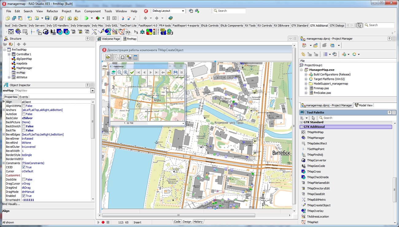
The toolkit consists of a set of visual components (supplied in source code) and a GIS core API for direct access to spatial data. The toolkit is intended for the development of client-server and desktop 32-bit and 64-bit applications that require processing and visualization of spatial data. Spatial data can be located both at the workplace (direct access to data), and in the local network or the Internet (components of access to the GIS Server or data exchange using international protocols are used).
The new version of the program is available for download on the page.


KB "Panorama" the version 13.5.0 has been developed for the operating system "Alt 8 SP" used in servers with the "Elbrus" processor architecture. In the new version of the service, the issuance of objects semantics in accordance with the passed list of values has been added. Support of several schemes for a layer has been implemented. This will allow to restrict and display only certain values of semantic characteristics, if objects have a lot of them, or to set the order of their display in and other clients of the service.
The service's capabilities for working with databases and 3D objects have been expanded. A new request has been added a for displaying metadata for SQLite databases. In order to reduce the load on the server, it is possible to receive the list of tracks as one file, rather than sending each request separately. The format of the GetLayers request output has been expanded. Ability was added to display maps with dimensions exceeding 180 degrees (for example, a map of Russia, where the Chukotka Autonomous Okrug is located on the right). User interface of service's administrator has been improved. Possibility was added to set styles for layers and to view statistics of service's work. Uniform style and appearance of administrator for all operating systems has been implemented.
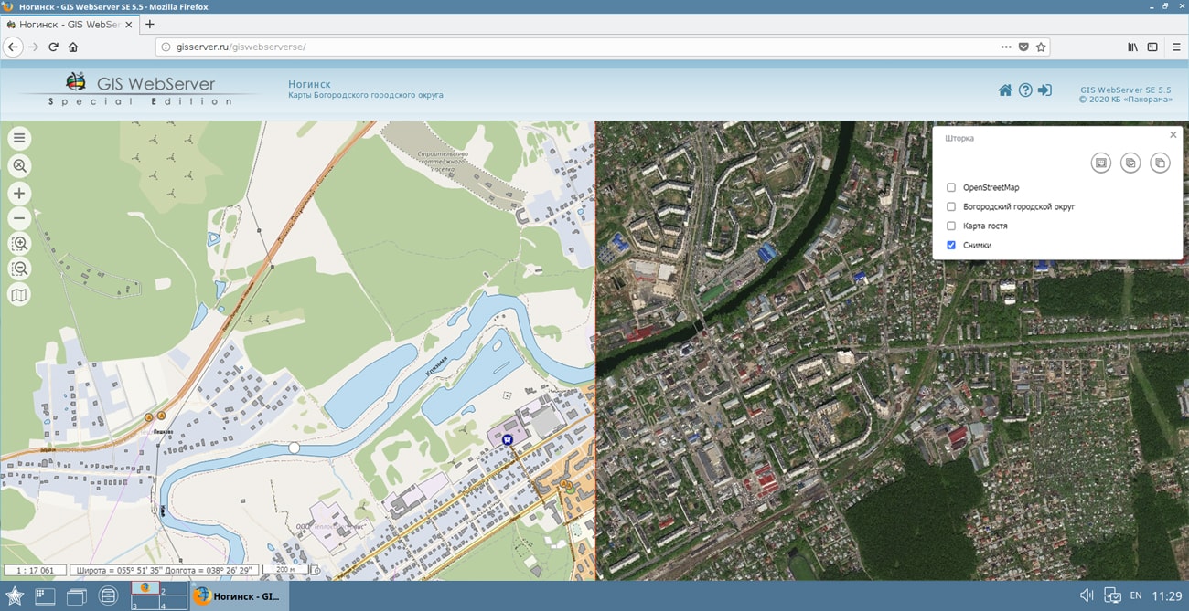
GIS WebService SE supports all international standards (OGC WFS, WFS-T, WMS, WMTS, WCS), which are used to transfer and display spatial data. The program implements the ability to issue tiles for any user or local coordinate system. The application is implemented on Windows and Linux platforms and is compatible with Apache, IIS and nginx web servers.
The new version of the program and documentation are posted on the website in the section.


In KB "Panorama" the version 13 for OS Astra Linux SE (Release "Smolensk") has been developed. In the new version a reading and editing of sets of vector maps in volume in of several GB located on the were optimised. At the initial opening, the data is cached on the client side and then the program will work with the local maps. This reduces the load onto the network when large numbers of users work with data hosted remotely. The loaded information is displayed using updated rendering algorithms, increasing the display speed.
The task of importing data of 3D model from TLS/OC3/DAE formats into DB3D format has been added. The TLS format is a binary file that stores the coordinates of textured 3D models with support for levels of detail, the models have a tiled structure. This format was developed by Agisoft company and implemented in the Agisoft Photoscan software product. The Sputnik software of the GeoScan group of companies works with the TLS format. The OC3 format is a binary file that stores coordinates and colors for points, which are combined into tiles distributed across levels of detail. The DAE (COLLADA) format stores a 3D model, the parameters of which are described in an xml file. If the model has textures, then they are stored in graphic files, which are usually located in a separate directory. DB3D format is a file of SQLite 3.0 and higher database, where the description of 3D models on the ground is stored in the form of tables. Viewing models together with a map is possible in the "Navigator 3D" task, the degree of detail of the models depends on the display scale.
Support of the packed MPTZ project has been added. A packed project may include a comprehensive representation of the territory in the form of vector maps of different levels of detail, rasters (terrain images) in the RSW format, elevation matrixes and matrixes of qualitative characteristics of the terrain, insets from the same data, the links to data from the GIS Server and from geoportals by various protocols. All data sets are packed into one file of MPTZ format. Links to external data are saved as a packed INI file. Maps and classifiers are compressed in 3-4 times, matrixes are compressed in 3-5 times, rasters are compressed in 3-10 time. Images of terrain in RSW and a matrix in MTW and MTQ contain 4 levels of data presentation - the most detailed base, generalised in the 1/4 scale, generalised in the 1/16 scale, generalised in the 1/64 scale. When displayed, the closest level of data representation is selected.
Speed of displaying MPTZ project is approximately the same, as at the initial uncompressed data. The speed of data exchange, packed into an MPTZ project, increases by 5 - 20 times, taking into account the decrease in the number of transferred files (for example, the original map can consist of several thousand files). The size of the MPTZ file and the number of sets in the project is not limited. Editing and exporting to other formats is not available for an MPTZ project.
The use of the MPTZ format makes it possible to change the system of storage, delivery and use of topographic and geodetic information in federal and regional government bodies, law enforcement agencies, large companies and for individual consumers.
Support for the RSCZ format - an RSC classifier file packed into a zip archive has been added. The volume of the stored file is reduced on average by 4-5 times without loss of data opening speed. RSC classifiers can be replaced at any time with packed files with the rscz extension. At opening a vector map, the GIS checks the presence of classifiers with extension rsc and rscz. The packed classifiers open only for reading.
At maps sorting with compression into MAPZ\SITZ format, the RCS classifier is compressed and recorded together with a map. Into one file MAPZ the works region from several thousand sheets with the classifier can be written down, that simplifies an exchange and application of vector maps.
ZIP has been added into the list of openable formats. When selected, zip is automatically unpacked onto the folder /tmp/Panorama.Cache/. The data opens in order of priority: the map project, vector maps, rasters, matrixes. This allows geodata projects to be archived, copied, and quickly viewed. The data in the archive opens for reading. After closing the unpacked data they automatically are deleted.
The operator.rsc classifier has been improved. For symbols of ships from layers "Navy. Combat ships and boats", "Navy. Special purpose ships", "Navy. Support ships and enemy ships", in accordance with KEUZ, the binding point is placed into the bow of the ship instead of the center of the symbols. Conventional symbols of object states: damaged and destroyed - are enlarged for clarity.
In the task "Save vector map in files of graphic formats" the list of formats of target files has been expanded. Along with BMP, TIFF, JPEG and RSW formats, the formation of a map image into a PNG file has been added. A fragment of a document of digital map of any type and content can be saved, including vector maps, rasters and matrixes, as well as geospatial data from external Internet resources (WMS and WFS - services). The ability has been implemented to save the map image by the selected area, by the page format and by the dimensions of the selected objects, for example, by the dimensions of the frames of the nomenclature sheets. The limitation on degree of increase in the image of rasters and matrixes is excluded. Rasters and matrixes which were drawn up to a scale 1:10, are drawn now without limiting the increase in a picture.
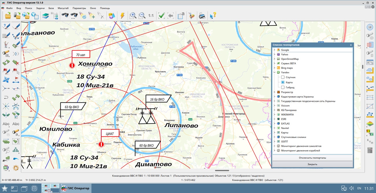
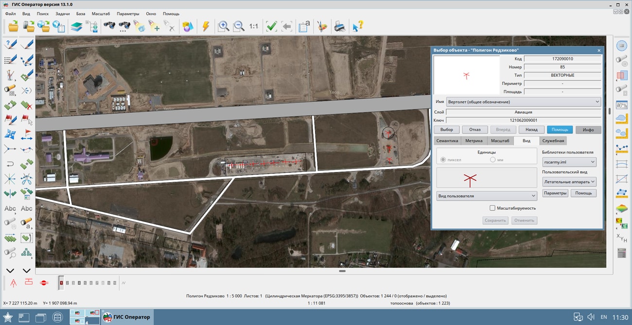
GIS "Operator" SE is a universal domestic geographic information system for power structures. The program is intended for accumulation, the storage, the automated processing and displaying the data, results of calculations and the forecasts having a geospatial binding. GIS "Operator" contains tools for displaying and processing vector, raster and matrix maps. The application provides users with tools for solving specialized tasks of modeling the movement of special objects against the background of 3D model, a forecasting the consequences of emergencies on hazardous objects, a monitoring the movement of aircraft, a performing the geodetic and topographic work, processing data from GPS/GLONASS navigation devices, a printing the displayed spatial data to various output devices and many others.


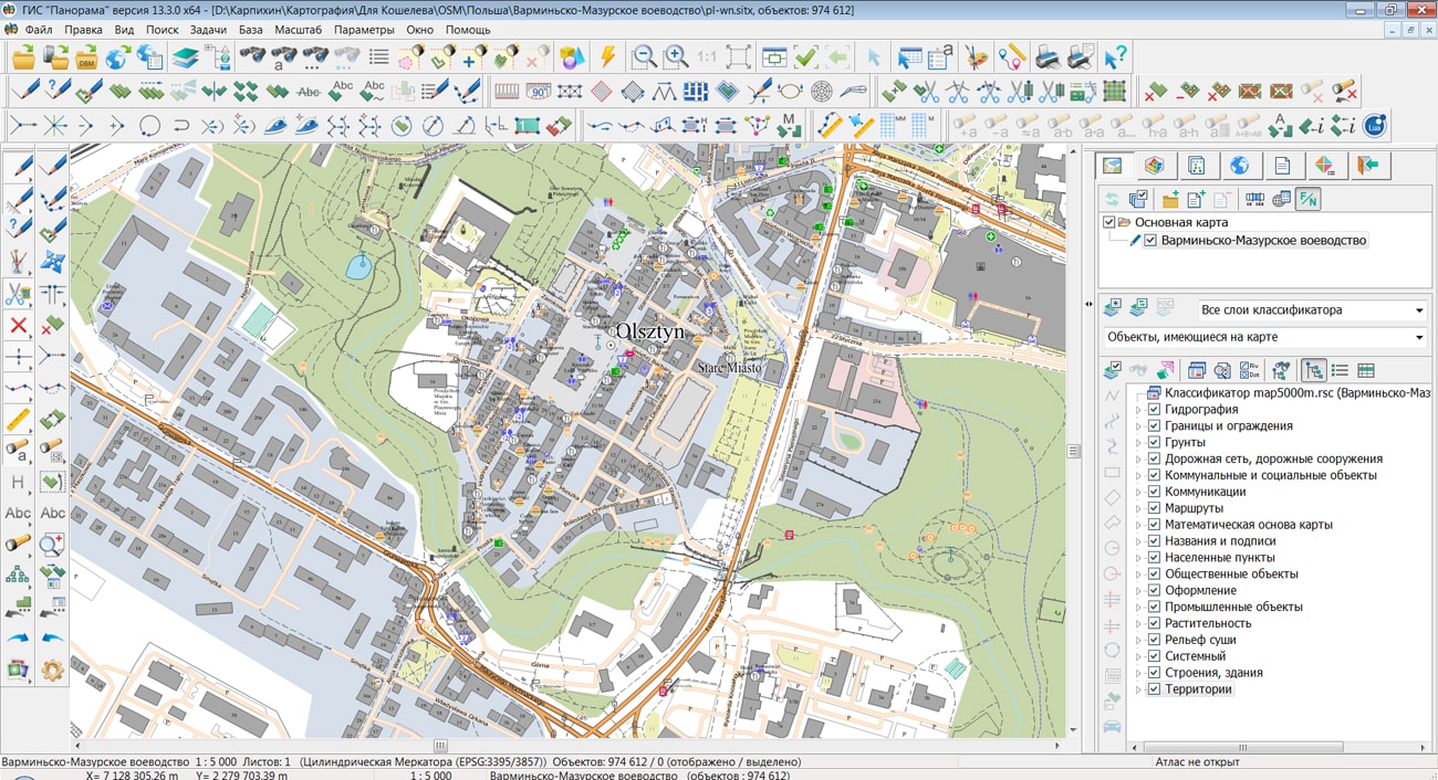
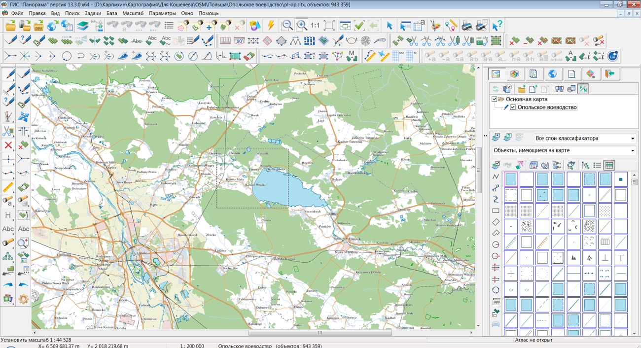
Geoportal is supplemented with a map of the Republic of Poland, formed according to OpenStreetMap data. Source data obtained from website. The composition includes maps of 16 voivodeships: Warmian-Masurian, Greater Poland, West Pomeranian, Kuyavian-Pomeranian, Lodz, Lublin, Lubusz, Masovian, Lesser Poland, Lower Silesian, Opole, Subcarpathian, Podlaskie, Pomeranian, Holy Cross and Silesian. To work with maps, you can use the program or other software products of KB "Panorama".
The map was led to the modernised classifier of large-scale plans of scale 1: 5 000 (map5000m.rsc). Publishing of updates in bank of spatial data is made by using the program of . Publishing contents of bank of spatial data on the geoportal and data access for downloading are implemented by means of .


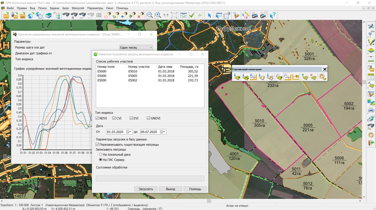
In KB "Panorama" the "Workstation of agronomist" version 13.4.1 has been developed. In the new version the possibilities of satellite monitoring of agricultural lands were expanded and possibility of work with agricultural lands of complex shape has been added. Now objects for registration in the integrated web service can be represented by multipolygons consisting of any number of external or internal contours. This possibility allows you to more accurately mark the borders of agricultural land, taking into account the road network passing through them, land reclamation facilities and distinguishing natural areas not used for agriculture.
The use of a modern approach to agricultural land management based on Earth's remote sensing data simplifies monitoring of large areas using a large number of indicators. Into "Workstation of agronomist" support of packed MPTZ project has been added. A packed project may include a comprehensive multi-scale representation of the territory in the form of vector maps of different levels of detail, rasters (terrain images) in the rsw format, elevation matrixes and matrixes of qualitative characteristics of the terrain, insets from the same data, the links to data from the and from geoportals by various protocols. Maps and classifiers are compressed in 3-4 times, matrixes are compressed in 3-5 times, rasters are compressed in 3-10 time. Each image of terrain in rsw and a matrix in mtw and mtq contain a pyramid of tiles of 4 levels of data presentation - the most detailed base, generalised in the 1/4 scale, generalised in the 1/16 scale, generalised in the 1/64 scale. When displayed, the closest level of data representation is selected. The project may have images of different levels of detail with overlap and a given range of display scales.
Using the external web service Geosys the "Workstation of agronomist" on the basis of a large array of satellite imagery implements the functions of precision farming. The program has the ability to obtain matrixes of the main vegetation indices (NDVI, CVI, EVI and GNDVI) for assessing the state of agricultural land, for building maps of field heterogeneity for a given number of zones, predicting yield based on the dynamics of changes in indicators for different seasons and creating maps for differentiated fertilization for different scripts.
The use of remote sensing data of the earth, the results of satellite navigation measurements, the readings of various sensors and the construction of a corporate agrarian geoinformation system on their basis have already proven their high efficiency in the management of agrotechnical measures and ensuring reliable control of crop cultivation technologies. Using the maps of differentiated application of fertilizers reduce costs and allows to achieve more level of crop yield.
The line of agricultural geoinformation systems of KB "Panorama" includes software products: , , , "Workstation of agronomist", Panorama AGRO Service and GIS . Their various combinations in common with the cartographical server (GIS Server) and professional the allow to create corporate geoinformation systems of any complexity.


Ph.: +7 (495) 739-0245, +7 (925) 221-1603
www.gisinfo.ru | panorama@gisinfo.ru
105005, Russia, Moscow, Baumanskaya Street 7, building 1, office 229 (m. Baumanskaya)
Copyright © Panorama Group 1991 - 2024


 Mobile version
 Full version