Copyright © Panorama Group 1991 - 2024

In KB "Panorama" the "Automated workplace of the cadastral engineer" version 13.4 was developed. In the new version, the mode "Reading the cadastral plan of the territory and updating the map" has been improved. There is implemented a support for the XML scheme used for formation of the XML document - an extract about a zone with special conditions of using the territories, the territorial zone, the territory of the cultural heritage site, the territory of priority social and economic development, the zone of territorial development in the Russian Federation, gambling zone, forestry, forest park, a specially protected natural area, a special economic zone, a hunting ground, a coastline (border of a water object), a land surveying project in electronic form.
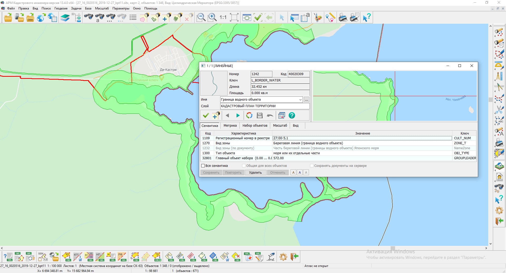
The list of conventional symbols for displaying cadastral objects characterizing the boundaries of a water object has been expanded. A linear object "Water object zone" has been added into the survey.v5.rsc classifier to describe coastlines of reservoirs, large lakes, seas and other water objects, the border of which is not completely described, but in the form of separate fragments. The use of conventional symbols of linear map objects allows you to correctly display open coastlines of water objects that are cadastral registered. The algorithm for reading spatial data of an object of discrete cadastral objects has been updated. If there is information about the radius, the real estate object is created as a point one by the coordinates of the center, and the radius value is written into the semantics of the object.
Collective use of "Base of cadastral works" of SQLite format was implemented, which contains information about cadastral engineers, contracts on execution of works, customers of cadastral works and other information. In program options the possibility has been added to choose the location of the file "Base of cadastral works" when network access. For convenience of identifying the information in headings of dialogs for working with «Base of cadastral works» the path to the database file is displayed.
The mode "Editing attributes of a cadastral object" has been improved. The exchange of information about points of the reference boundary network with the dialog "Land Survey plan" has been implemented. In addition to information about the geodetic basis, there is provided an exchange of information about the list of documents used in the preparation of the survey plan and on the initial parts of the land plot. The procedure for obtaining location coordinates by address has been updated, the ability for geocoding of addresses with using the Yandex services has been added. This possibility is supported for users who have a Yandex license API-key.
The new version of the program is available on the website in the Download section.


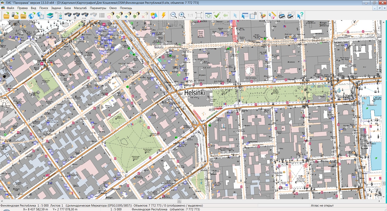
On the geoportal , the map of the Republic of Finland, formed according to OpenStreetMap data, was updated. The source data was obtained from the website. For work with the map it is possible to use the program of GIS Panorama Mini or other software products of KB "Panorama".
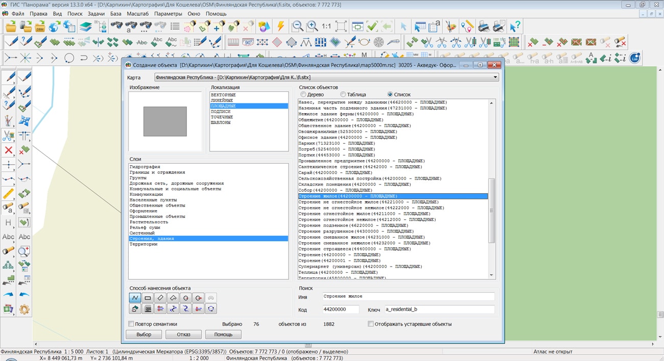
The map was led to the modernised classifier of large-scale plans of scale 1: 5 000 (map5000m.rsc). Publishing of updates in bank of spatial data is made by using the program of . Publishing contents of bank of spatial data on the geoportal and data access for downloading are implemented by means of .
Free maps on the basis of OpenStreetMap data are available for download on the page "Digital maps and images".


In KB "Panorama" the version 13.4.0 is developed. In the new version a support of packed MPTZ project has been added. A packed project may include a comprehensive multi-scale representation of the territory in the form of vector maps of different levels of detail, rasters (terrain images) in the rsw format, elevation matrixes and matrixes of qualitative characteristics of the terrain, insets from the same data, the links to data from the and from geoportals by various protocols. All data sets are packed into one file of mptz format. Maps and classifiers are compressed in 3-4 times, matrixes are compressed in 3-5 times, rasters are compressed in 3-10 time. Each image of terrain in rsw and a matrix in mtw and mtq contain a pyramid of tiles of 4 levels of data presentation - the most detailed base, generalised in the 1/4 scale, generalised in the 1/16 scale, generalised in the 1/64 scale. When displayed, the closest level of data representation is selected. The project may have images of different levels of detail with overlap and a given range of display scales. To create the mptz project, you need to open the corresponding maps, rasters, matrixes, data from GIS Servers and geoportals. Then make settings for display order, visibility borders, palette and other properties. To write to mptz, select the menu item File\Save As\Packed Project. Editing and export to other formats are not available for the mptz project. The mptz project display speed is about the same one, as for the original uncompressed data. The speed of exchanging by packed data is increasing by 5 to 20 times, taking into account the reduction in the number of transferred files (for example, the original map map may consist of several thousand files). The size of mptz file and number of sets in the project are not limited. Simultaneously without additional preparation it is possible to open any number of MPTZ projects, covering any territories in the form of a mosaic.
The use of the MPTZ format allows you to change the system of storage, finishing and application of topographic and geodetic information in federal and regional government bodies, law enforcement agencies, large companies and for individual consumers.
The task of thematic mapping has been improved. Automatic calculating the irregular ranges of characteristics values of a thematic map has been added. A thematic map with displaying of quantitative indicators can be built on a map with minimal semantic content, for example, on an OpenStreetMap map. It is enough to select the objects of interest (Pharmacies or Shops) on the map, and in the dialog in the "Coloring by number of objects" mode, by use of the "Filter" button to customize the composition of the administrative territories (urban area, village council). At the end of the composition customization, a statistical analysis is performed, as a result of which the values of the range borders are calculated. This method allows you to minimize manual operations for setting ranges.
In the "Classifier Editor" task, the possibilities has been improved for import of three-dimensional models from the COLLADA (DAE) format. To optimize the size of loaded model, the following import modes have been added: without changing the original geometry, with removal of all duplicate vertices, removing duplicate vertices, taking into account the illumination along the edges. Import with the removal of vertices can significantly reduce the size of the original model due to the uniqueness of each loaded vertex and face. Vertex duplication in the initial model can occur due to the participation of one vertex in several faces, when a normal is described for each vertex instance. Optimization of models when import accelerates the display of a three-dimensional terrain model.
In the "Navigator 3D" task, support has been added for the new geoportal "Monitoring the movement of ships" in three-dimensional form. Geoportal allows you to display real-time data about the location of ships on the base of an automatic identification system of data (AIS). It allows you to receive data from transponders of ships, satellites and ships monitoring system (VTS), and also to view their characteristics. From the Flightradar24 geoportal (aircraft monitoring), you can track the position of aircrafts. The service uses ADS-B receivers installed around the world that receive information from aircraft equipped with an ADS-B transponder and send it to the Flightradar24 server. Aircraft and ships on a 3D map are displayed by different types of models, depending on their type, size, capacity. All types of ships are assigned the appropriate three-dimensional models in the service library of three-dimensional symbols. Water vessels are displayed as off-scale models, which allows the user to see them on a small-scale three-dimensional terrain model, and when magnified without significant distortion.
In addition to displaying real data, you can perform modeling by scenario. In the example data for the Noginsk map, a scenario of moving objects was added - .\scenario\scen_nog.xml, which can be viewed in the "Navigator 3D" task. On a three-dimensional model of Noginsk, transport models moving along given trajectories will appear. In the "Tools" menu item, as well as on the "Toolbar", there are scenario controls: start of scenario, pause, stop of scenario, scenario setup.
The type of messages for the tasks "Map Editor" and "Map Computer" has been changed. Instead of messages requiring the operator to press a button, pop-up messages have been added informing about the result of the performed action. For example, "Copied to the clipboard: 200 objects" or "The frame for the selected object is not set". An informational or error warning message pops up in the lower right part of the main GIS window and will close after a while. The text of the error message is highlighted in red. All messages are recorded in the "Message Log", which is located in the line at the bottom of the GIS window in the form of a drop-down list. Each record contains the time, text, and title of the message. Viewing the message log is carried out with a single click on the message line in the status bar of the main window. Each open document has its own list of messages.
There is optimized a reading and editing sets of vector maps with a volume of several GB, located on the GIS Server. The speed of data display has been increased, the amount of data transmitted over the network has been reduced.
In the application task "Report Designer", the tools for constructing the map legend were modernized. The generated legend can be saved as a map in SITX format or as an image in JPG format for further use as additional graphic materials when generating report layouts.
The task "Object selection" has been improved. On the "Semantics" bookmark the abilities to sort the table have been expanded. Data can be sorted by code, the name of the semantic characteristic, by the value of the characteristic and in the order established in the classifier for this type of map object. Sorting type can be selected through the "Sort" context menu.
The options for selecting objects in the dialogs "Map Contents" and "Search for Map Objects" are expanded. The list of objects is presented in the form of a table with the columns "Name", "Code", "Character Code", "Key", "Type". The list of objects is ordered by the values of elements in any column, which is performed by clicking on the column heading. The search for an object in the list can be performed by the value of the element in any column.
The mode "Export of heights matrix to TIFF format" has been improved. In dialog the possibility was added for saving all matrixes of the document into files of TIFF format.
The new version of the program is available for download in the section.


On the geoportal , the map of Mongolia, formed according to OpenStreetMap data, was updated. The source data was obtained from the website. For work with the map it is possible to use the program of GIS Panorama Mini or other software products of KB "Panorama".
The map was led to the modernised classifier of large-scale plans of scale 1: 5 000 (map5000m.rsc). Publishing of updates in bank of spatial data is made by using the program of . Publishing contents of bank of spatial data on the geoportal and data access for downloading are implemented by means of .
Free maps on the basis of OpenStreetMap data are available for download on the page "Digital maps and images".


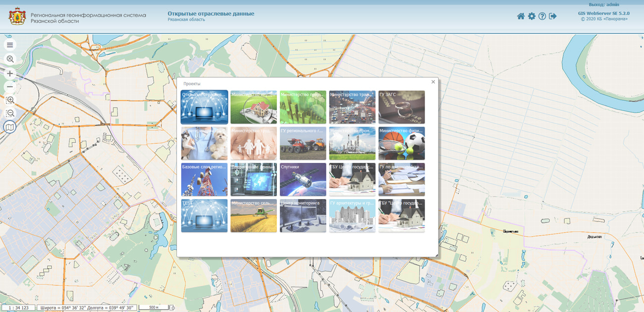
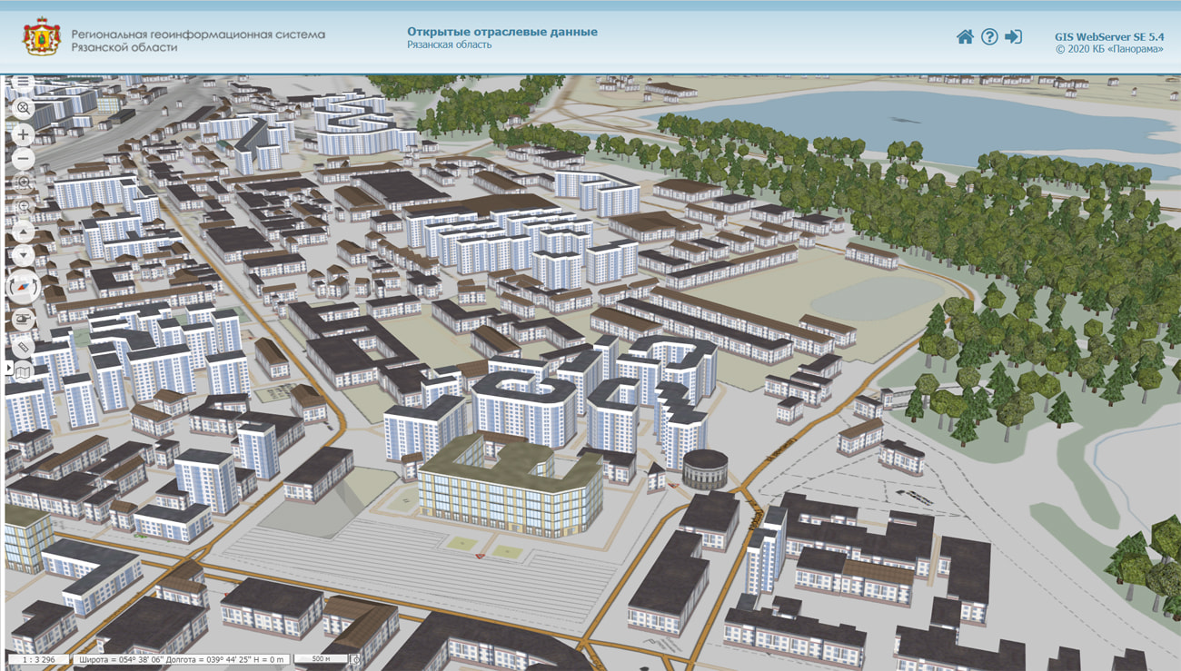
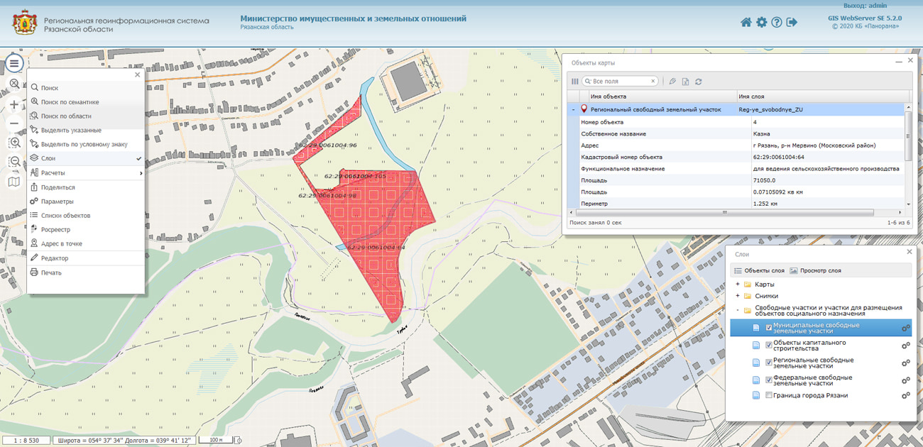
As part of the software and hardware support of the state information system "Regional Geoinformation System of the Ryazan Region" (RGIS RO), the corresponding has been launched. RGIS is intended for use in order to obtain reliable spatial information about the Ryazan region, the formation and integration of information resources about its territory, necessary for the exercise of authority and decision-making by public authorities of the Ryazan region.
The RGIS of the Ryazan region is a combination of software and information resources providing the placement, storage, updating of data coming into the system from various sources, and also their visualization and analysis. RGIS RO uses server and client products included in the register of domestic software.
The regional geographic information system of the Ryazan Region is built entirely on serial products of KB Panorama and includes the , , . As desktop applications, is used in conjunction with complexes of and urban-planning tasks.


Ph.: +7 (495) 739-0245, +7 (925) 221-1603
www.gisinfo.ru | panorama@gisinfo.ru
105005, Russia, Moscow, Baumanskaya Street 7, building 1, office 229 (m. Baumanskaya)
Copyright © Panorama Group 1991 - 2024


 Mobile version
 Full version