Copyright © Panorama Group 1991 - 2024

In KB "Panorama" the generalization of settlements titles for digital geographic maps of scale 1: 1 000 000 in the SXF format, formed according to (www.gis-lab.info), was performed. As a result of generalization, the general appearance of the maps is improved and the superimposition of titles for any scale is eliminated.
The maps were led to the classifier of geographical maps of scale 1: 1 000 000 (1mogk13g.rsc). Maps were led to the classifier of geographic maps of scale 1: 1 000 000 (1mogk13g.rsc), were supplemented by information on the quantity of inhabitants for cities and by the names of settlements in Russian. It can be used for the general estimation of the terrain and studying of an environment, an ensuring of educational process, as a basis for creation of geographical maps of smaller scale, thematic and special maps and solving other tasks. Maps are distributed free according to the free .
Digital geographical maps of scale 1: 1 000 000 in format SXF are available for downloading on page the "Digital maps and images".


In KB "Panorama" the (RSE) version 4.2 is developed. The new version improves the processing of requests for obtaining data of large volume. Speed of forming the archive with data is increased. Data can be received via HTTP protocol or through an exchange folder. Ability is added the to select the mode of archiving spatial data. The location of data in the archive and the exchange folder can be at the same nesting level or with subdirectories. There is implemented the ability to obtain geodata on request, with different parameters for the archive formation.
The list of logged user actions has been expanded. Creation of separate log with the list of deleted data sets is added. Logging of the request execution process is implemented. A report is generated from the user's actions log, which can be printed using browser tools.
Within the framework of a single geoinformation space, the Data Bank of digital maps and remote sensing data realises gathering, storage, search and delivery of the spatial data in exchange formats. The spatial data selected by means of the program can be placed for the multiuser access on the and be published according to the international standards OGC WFS, WFS-T, WMS, WMTS, WCS on application server the . Users can access data from both a thin client (by means of ) and from desktop applications (, ). The databank of digital maps and remote sensing data provides construction of cloud warehouse of spatial data, provision of access to these data, the automated formation and updating of geo-covers. The current state of spatial data is displayed by means of maps-schemes that are maintained for each type of stored data: vector maps, remote sensing data, elevation matrixes and terrain models. It provides remote placing the sets of spatial data into file warehouse, keeping versions of stored sets, updating maps-schemes of data availability, the automated collection and formation of metadata, and the formation and updating of geo-covers. Automated collection and formation of metadata is performed according to the standards of ISO 19115: 2003, Geographic information - Metadata and ISO/TS 19139, Geographic information - Metadata - XML schema implementation. The reduced copies of data images are automatically formed, checksum of files and completeness of data sets are checked.
The new version of the program is available for download on the page.


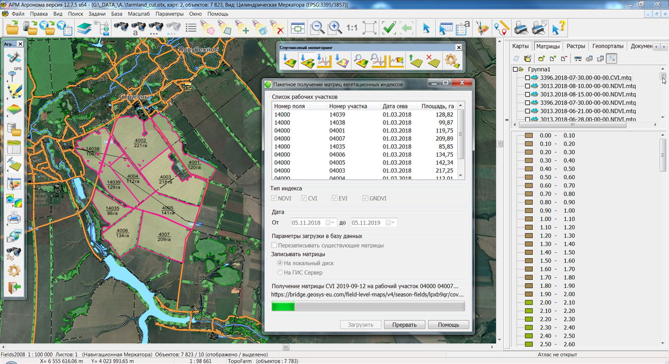
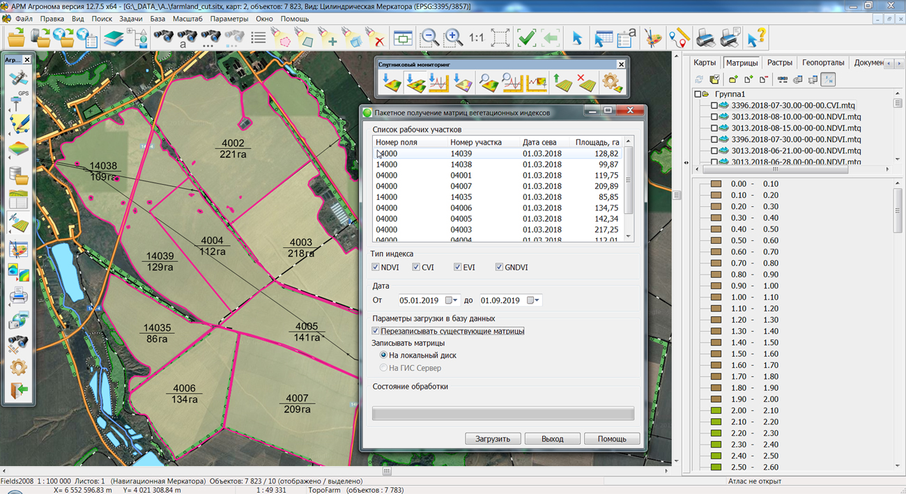
In KB Panorama the "Workstation of Agronomist" version 12.7.5 is developed. The new version provides advanced tools for obtaining and viewing the data of remote sensing the Earth (RSE) on agricultural land. Improved mode "Viewing data of RSE" simplifies monitoring of agricultural areas at the expense of viewing maps of heterogeneity, requirements of nitrogen and matrixes of values of vegetation indexes simultaneously on several agricultural lands. The updated interface allows you quickly to switch data on the necessary dates for a more convenient study of the dynamics of changes in the properties of vegetation.
In the task "Satellite monitoring", the mode of fast viewing the remote sensing data before loading the matrixes of vegetation indexes has been improved. New options allow you to display values of indexes with a static legend, at which colors of values are predetermined for all range of index values and do not depend on a minimum and a maximum for a concrete contour of a field. The static legend clearly shows the change in vegetation indexes on a working area for different dates, makes it possible to compare vegetation development on the neighboring fields and allows to select quickly images for constructing maps of the differentiated application or the further analysis.
Vegetation indices are numerical indicators calculated on the basis of remote sensing data that reflect the amount of vegetation biomass. In a modern approach to the management of agricultural areas, vegetation indices are used for evaluation of the health of vegetation, a forecasting of crop yield and increase the efficiency of fertilizer application by creating maps of differential application. Complex of agronomic tasks supports an obtaining the main types of vegetation indices: NDVI, CVI, EVI, GNDVI and zoning maps for nitrogen and vegetation heterogeneity.
All modes of satellite monitoring work with database of and support a placing of data on the for maintenance of collective multiuser access. The download source is the web service.


In KB "Panorama" the version 12.6.0 is developed. In the new version a fault tolerance of execution of the user requests to the spatial data located on the is increased. The speed of receiving a large volume of transactions has been increased. There is added a setting of internal server parameters - the number of simultaneously connected users, the number of critical errors in connecting to the service. Support for multithreaded drawing of projects is improved. Taking into account the parameters of elevations matrixes during the formation of tiles is implemented. Support of the maps is added that consist from insets (an array of geospatial data organized as nesting and limited by a frame).
In order to improve the interaction of the service with other clients, a setting has been added for interpretation of the input coordinates: latitude/longitude or longitude/latitude, both for the entire service and in individual requests. User interface for setting parameters for working with the service is improved.
GIS WebService SE supports all international standards (OGC WFS, WFS-T, WMS, WMTS, WCS), with the help of which the transmission and display of spatial data is carried out. The program has the ability to issue tiles by any user or local coordinate system. The application is implemented on Windows and Linux platforms, is compatible with Apache, IIS and nginx web servers.
The new version of the program and documentation are available on the website in the section.


Specialists of KB "Panorama" prepared the video lesson . It is intended for the English-speaking users independently studying possibilities of the . In this lesson the possibilities for export of vector maps into Shapefile format are demonstrated.
The training material acquaints users with features of work the "Export to Shape format" task, which includes setting the attribute fields and processed data, coordinates format, encoding, and other modes. The attributes of the objects are written into the DBF file, and the coordinates of the objects are recorded in the WGS-84 geodetic system in degrees. If you are exporting a large-scale plan with unknown projection parameters, then the coordinates are recorded in meters in the local system. For the convenience of work, it is possible to save user settings.
Previously the video lessons of this series were published: , , , , , , and others.
You can get acquainted with training materials in English in the section .


Ph.: +7 (495) 739-0245, +7 (925) 221-1603
www.gisinfo.ru | panorama@gisinfo.ru
105005, Russia, Moscow, Baumanskaya Street 7, building 1, office 229 (m. Baumanskaya)
Copyright © Panorama Group 1991 - 2024


 Mobile version
 Full version