Copyright © Panorama Group 1991 - 2024

In KB "Panorama" the "Workstation of agronomist" version 13.4.1 has been developed. In the new version the possibilities of satellite monitoring of agricultural lands were expanded and possibility of work with agricultural lands of complex shape has been added. Now objects for registration in the integrated web service can be represented by multipolygons consisting of any number of external or internal contours. This possibility allows you to more accurately mark the borders of agricultural land, taking into account the road network passing through them, land reclamation facilities and distinguishing natural areas not used for agriculture.
The use of a modern approach to agricultural land management based on Earth's remote sensing data simplifies monitoring of large areas using a large number of indicators. Into "Workstation of agronomist" support of packed MPTZ project has been added. A packed project may include a comprehensive multi-scale representation of the territory in the form of vector maps of different levels of detail, rasters (terrain images) in the rsw format, elevation matrixes and matrixes of qualitative characteristics of the terrain, insets from the same data, the links to data from the and from geoportals by various protocols. Maps and classifiers are compressed in 3-4 times, matrixes are compressed in 3-5 times, rasters are compressed in 3-10 time. Each image of terrain in rsw and a matrix in mtw and mtq contain a pyramid of tiles of 4 levels of data presentation - the most detailed base, generalised in the 1/4 scale, generalised in the 1/16 scale, generalised in the 1/64 scale. When displayed, the closest level of data representation is selected. The project may have images of different levels of detail with overlap and a given range of display scales.
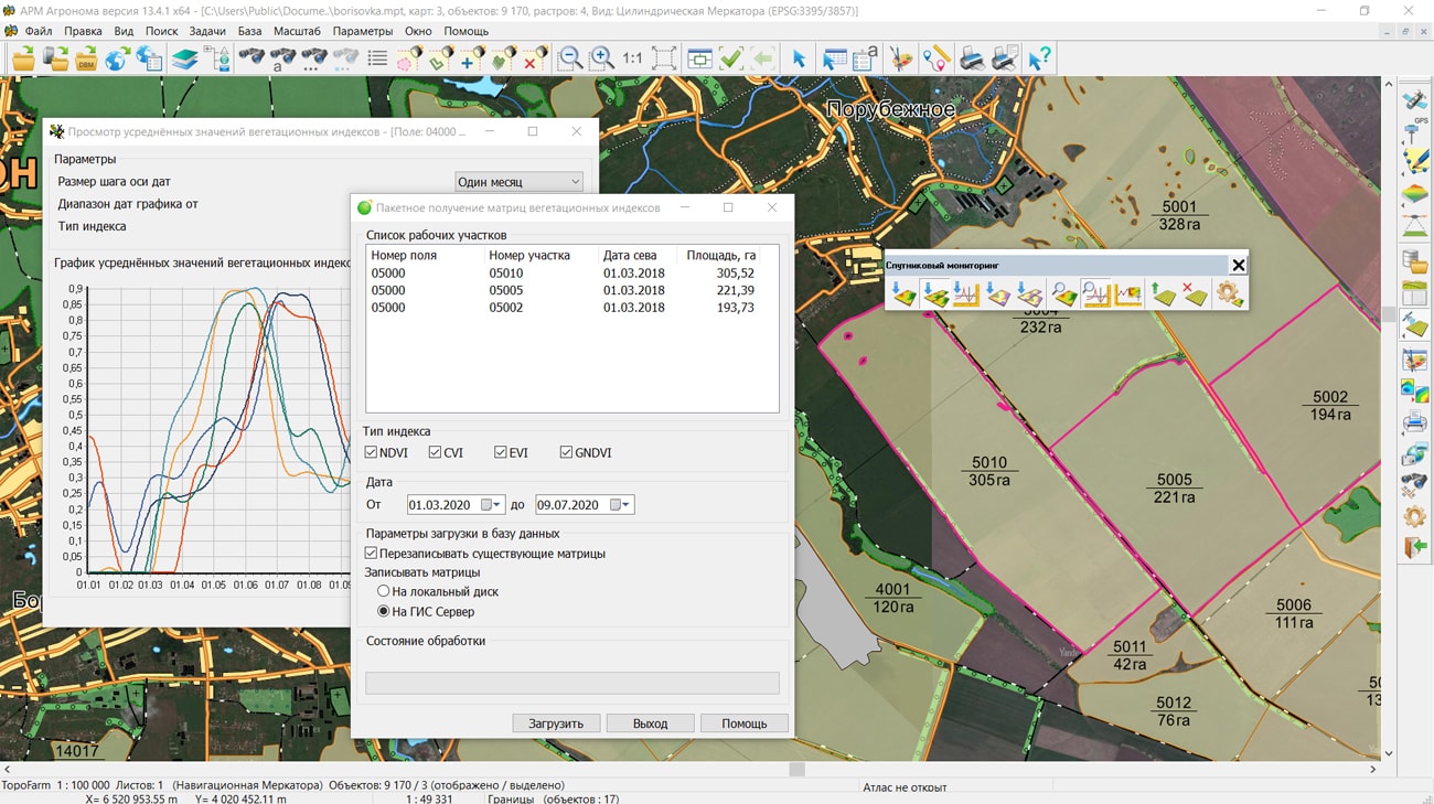
Using the external web service Geosys the "Workstation of agronomist" on the basis of a large array of satellite imagery implements the functions of precision farming. The program has the ability to obtain matrixes of the main vegetation indices (NDVI, CVI, EVI and GNDVI) for assessing the state of agricultural land, for building maps of field heterogeneity for a given number of zones, predicting yield based on the dynamics of changes in indicators for different seasons and creating maps for differentiated fertilization for different scripts.
The use of remote sensing data of the earth, the results of satellite navigation measurements, the readings of various sensors and the construction of a corporate agrarian geoinformation system on their basis have already proven their high efficiency in the management of agrotechnical measures and ensuring reliable control of crop cultivation technologies. Using the maps of differentiated application of fertilizers reduce costs and allows to achieve more level of crop yield.
The line of agricultural geoinformation systems of KB "Panorama" includes software products: , , , "Workstation of agronomist", Panorama AGRO Service and GIS . Their various combinations in common with the cartographical server (GIS Server) and professional the allow to create corporate geoinformation systems of any complexity.


In KB "Panorama" the software products have been developed for the operating system "Astra Linux Special Edition", release "Leningrad" on the platform "Elbrus" with microprocessor "Elbrus-8C". Processors based on the Elbrus architecture, developed by company, are the leading domestic solution for the military-industrial complex and the public sector.
The programs for the Elbrus platform include the specialized for power structures, server applications the and , the map service, , a service for creating and updating pyramids of tiles the and the Databank of digital maps and remote sensing data. KB "Panorama" programs form a unified system for creating, storing, updating and publishing the spatial data with automated formation of geo-covers.
The GIS "Operator" for power structures is an information element of an automated control system that, using modern computer technologies, provides a visual representation, a processing and analysis of heterogeneous data used for information support of decision-making processes. GIS "Operator" contains tools for creating and editing digital maps of the operational situation, execution of various measurements and calculations, overlay operations, building 3D models, processing raster data, tools for preparing graphic documents in digital and printed form, as well as tools for working with databases.
GIS implements a flexible spatial data classification system, smart symbols; supports international standards OGС, ISO 19100, IHO, ICAO for the exchange and display of spatial data; uses a database of parameters of national coordinate systems according to the EPSG code. The program provides support for international standards for the display and storage of marine (IHO) and aeronautical (ICAO) data. The display of digital topographic, special maps and city plans by means of GIS is carried out in accordance with the requirements of the Information Cartographic Support of the RF Armed Forces (IKO-2008). Creation and display of the operational situation in the form of special maps is carried out in accordance with the Classifier of electronic conventional symbols of the operational environment (KEUS).
GIS WebServer SE is implemented on cloud technologies and provides construction of geoportals for various purposes. The program automates the publication of the changing spatial data on the basis of web-services. Creates new layers of data and allows to edit them. Combines the layers from various services and geoportals with recalculation of coordinate systems, selection of display order and layer transparency. Provides access to user data from any computer. Creates thematic maps and cartograms. Performs geodetic calculations on the ground. Displays 3D models based on open vector maps, DEMs and terrain images without preparing a model. Carries out search of the shortest routes by the graph of roads. As a source of spatial data the mapping service the GIS WebService SE is used. Data exchange with the GIS WebService SE service is performed according to the OGC WMTS, OGC WMS specification and the extended REST API interface over the HTTP protocol.
The service for creating and updating pyramids of tiles the Imagery Service provides the creation and updating of tile pyramids in PNG or JPEG format using spatial data controlled by the GIS Server. Tile pyramids can be published via the OGC WMTS protocol by the GIS WebService SE service or displayed in the GIS "Operator". Pyramids of tiles can be created on the basis of a combination of digital vector maps, space and aerial photographies, matrixes of the heights, data from geoportals and other data.
The databank of digital maps and remote sensing of the Earth provides accumulation, accounting, issuance of Geo-Spatial Information (GSI) (digital maps, remote sensing data, matrixes of heights, documents and points of the planned-high-altitude base), systematization of metadata of the GSI archive, collective access, displaying the metadata of Databank by means of a web browser , creation, maintenance and display of GSI availability schemes. The GIS WebService SE map service is used as a source of spatial data of the Databank. Data exchange with the mapping service is carried out through the execution of HTTP requests using the protocols of Open Geospatial Consortium (OGC): Web Map Tile Service (OGC WMTS), Web Feature Service (OGC WFS), Web Map Service (OGC WMS) and additional advanced requests of data based on REST API. To access the metadata schemes and placement of materials into the repository, the GIS Server software product is used. Microprocessors "Elbrus-8S" (1891VM10Ya) are high-performance general-purpose processors with improved architecture "Elbrus", which allows performing up to 25 operations per clock cycle in each core - 250 billion floating point operations per second. The presence of 4 channels of access to memory and 3 channels of interprocessor exchange allows building scalable computing systems that provide a high speed of information processing and transmission.
New versions of programs are available for download in the section.


KB "Panorama" received certificates of conformity for software products Geoinformation system "Map 2005 Version 12" () and .
GIS "Panorama x64" contains tools for creation and editing of digital maps and plans of cities, execution of various measurements and calculations, overlay operations, building the 3D models, processing the raster data, tools of preparing graphic documents in a digital and printed form, and also toolkit for work with databases.
GIS implements a flexible classification system of spatial data, smart conventional symbols; supports the international standards OGС, ISO 19100, IHO, ICAO for an exchange and display of spatial data; uses a database of parameters of national coordinate systems by EPSG code. The program uses common formats for the exchange of spatial data, combines the data from databases and data from open sources, using web-browser protocols. GIS "Panorama x64" includes the professional editor of digital topographical, sea, aeronautical and other maps and plans of cities, "Report designer", "Form Constructor", "GPS\GLONASS Monitor", the task "Automated generalization of topographical maps" (automated creation of small-scale maps by large-scale maps), the block of modes "Preparation for printing" and many others.
The program provides support for international standards for the display and storage of sea (IHO) and aeronautical (ICAO) data. Display of digital topographical, special maps and plans of cities by tool of the GIS is carried out in accordance with the requirements of the Information Cartographic Support of the RF Armed Forces (IKO-2008). Creation and display of the operational situation in the form of special maps is performed in accordance with the Classifier of electronic conventional symbols of the operational situation (KEUZ-2012).
GIS "Panorama x64" together with the Complex of automated interpretation and vectorization provides a powerful mechanism for processing Earth's remote sensing data (ERS). Complex of automated interpretation and vectorization is used for automatic vectorization of linear and areal objects using panchromatic, color and multispectral images of the earth's surface. In addition to topographic interpretation, the complex allows to perform multispectral classification of Earth's remote sensing data. For these purposes, statistical and texture features are used for any raster channel or virtual channels, calculated by the NDVI formula.
GIS "Panorama x64" and "Complex of automated interpretation and vectorization" are certified in the certification system of information security tools of the Ministry of Defense of the Russian Federation according to level 2 of the control of the absence of undeclared capabilities according to the guidance document of the State Technical Commission of Russia and according to the real and declared functionality in the documentation. Obtained licenses for the use of the mark of conformity for marking software products provide the KB "Panorama" with the right to manufacture and supply the GIS "Panorama x64" and the "Complex of automated interpretation and vectorization" for the Russian Federation Ministry of Defense.


In KB "Panorama" the professional vectorizer version 13.4.1 has been developed. In the new version of the program the view of messages for interactive modes is changed. Instead of messages requiring the operator to press a button, pop-up messages have been added informing about the result of the performed action. For example, "Copied to the clipboard: 200 objects" or "The frame for the selected object is not set". An informational or error warning message pops up in the lower right part of the main GIS window and will close after a while. The text of the error message is highlighted in red. All messages are recorded in the "Message Log", which is located in the line at the bottom of the GIS window in the form of a drop-down list. Each record contains the time, text, and title of the message. Viewing the messages log is carried out with a single click on the message line in the status bar of the main window. Each open document has its own list of messages.
A support of packed MPTZ project has been added. A packed project may include a comprehensive multi-scale representation of the territory in the form of vector maps of different levels of detail, rasters (terrain images) in the rsw format, elevation matrixes and matrixes of qualitative characteristics of the terrain, insets from the same data, the links to data from the and from geoportals by various protocols. All data sets are packed into one file of mptz format. Maps and classifiers are compressed in 3-4 times, matrixes are compressed in 3-5 times, rasters are compressed in 3-10 time. Each image of terrain in rsw and a matrix in mtw and mtq contain a pyramid of tiles of 4 levels of data presentation - the most detailed base, generalised in the 1/4 scale, generalised in the 1/16 scale, generalised in the 1/64 scale. When displayed, the closest level of data representation is selected. The project may have images of different levels of detail with overlap and a given range of display scales.
To create the mptz project, you need to open the corresponding maps, rasters, matrixes, data from GIS Servers and geoportals. Then make settings for display order, visibility borders, palette and other properties. To write to mptz, select the menu item File\Save As\Packed Project. Simultaneously without additional preparation it is possible to open any number of MPTZ projects, covering any territories in the form of a mosaic.
The use of the MPTZ format allows you to change the system of storage, finishing and application of topographic and geodetic information in federal and regional government bodies, law enforcement agencies, large companies and for individual consumers.
The task of connecting geoportals has been improved. A new geoportal has been added - monitoring the movement of ships. This geoportal allows you to display real-time data on the location of all ships. To obtain data, an automatic identification system of data (AIS) is used. It allows you to receive data from transponders of ships, satellites and ship monitoring systems (VTS).
The block of geodesy and cadastral tasks has been improved. The mode "Reading the cadastral plan of the territory and updating the map" supports the XML-scheme extract_about_zones_v01 - an extract about zone. The list of conventional symbols for displaying cadastral objects characterizing the boundaries of a water object has been expanded.
A linear object "Water object zone" has been added into the survey.v5.rsc classifier to describe coastlines of reservoirs, large lakes, seas and other water objects, the border of which is not completely described, but in the form of separate fragments.
Collective use of «Base of cadastral works» of SQLite format was implemented, which contains information about cadastral engineers, contracts on execution of works, customers of cadastral works and other information. In program options the possibility has been added to choose the location of the file «Base of cadastral works» when network access. For convenience of identifying the information in headings of dialogs for working with «Base of cadastral works» the path to the database file is displayed.
The mode "Editing attributes of a cadastral object" has been improved. The exchange of information about points of the reference boundary network with the dialog "Land Survey plan" has been implemented. In addition to information on the geodetic basis, there is provided an exchange of information about the list of documents used in the preparation of the survey plan and on the initial parts of the land plot. The procedure for obtaining location coordinates by address has been updated, the ability of geocoding the addresses with using the Yandex services has been added. This possibility is supported for users who have a Yandex license API-key.
The task "Object selection" has been improved. On the "Semantics" bookmark the abilities to sort the table have been expanded. Data can be sorted by code, the name of the semantic characteristic, by the value of the characteristic and in the order established in the classifier for this type of map object. Sorting type can be selected through the "Sort" context menu.
There is optimized a reading and editing sets of vector maps with a volume of several GB, located on the GIS Server. The speed of data display has been increased, the amount of data transmitted over the network has been reduced.
The new version of the program is available for download in the section.


Ph.: +7 (495) 739-0245, +7 (925) 221-1603
www.gisinfo.ru | panorama@gisinfo.ru
105005, Russia, Moscow, Baumanskaya Street 7, building 1, office 229 (m. Baumanskaya)
Copyright © Panorama Group 1991 - 2024


 Mobile version
 Full version