Copyright © Panorama Group 1991 - 2024

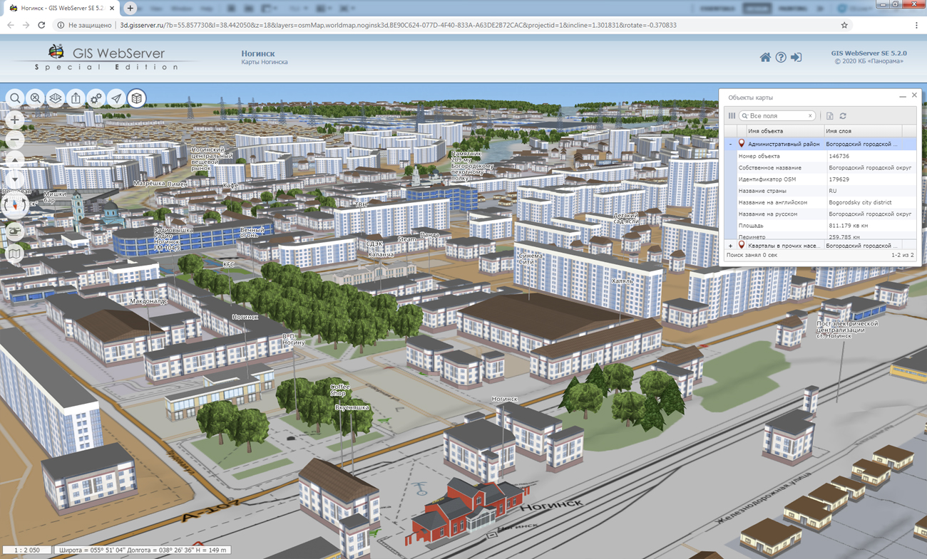
In KB "Panorama" the version 5.2 is developed for operating systems Astra Linux, CentOS and Windows. The new version of 3D map displays more detailed three-dimensional terrain models while maintaining high speed. The completely updated core of the 3D component allows you to increase the detail of the display up to 8 times. The screen refresh rate is up to 30 frames per second. Function of viewing the map in the "skeleton" mode is added to assess the complexity of scene models. It is possible to familiarise with new possibilities of a three-dimensional map on examples of model of and the simplified model of the city of .
The toolkit of developing the Web-applications the has been improved, which expands possibilities of GIS WebServer SE and can be integrated into other information systems. The 3D map component has expanded the list of labor-intensive tasks performed outside the main stream. There are added fundamental classes of the component (vectors, matrixes, geographic coordinates, spheroids), as well as algorithms and infrastructures (for example, message queue). At the level responsible for interacting with the video card, types have been developed that represent an abstraction for managing GPU resources and optimizing drawing calls. Scene level contains the ready structures, allowing on the basis of available data to carry out construction and display of the basic types of geoinformation models (globe, vector data, terrain relief, 3D tiles).
Access to data (images, vector maps and terrain information) is provided by web-services using common OGC protocols and ISO standards. Service of (OGC WMS/WMTS) provides spatial information in the form of graphic images. Various types of high-altitude data are used as a digital elevation model: matrixes (in the formats SRTM, GeoTIFF, IMG, MTW), TIN-models, point cloud and others. The service provides the ability to publish three-dimensional terrain models unloaded in DB3D format. These models can be obtained from files of the COLLADA type, as well as from photorealistic three-dimensional models of unlimited size (TLS, OC3).
As a source of spatial data, the can be. It provides the collection, storage, search and delivery of spatial data in exchange formats, a displaying the state of the data bank in the form of maps-schemes, the automated formation and updating of geo-covers.
GIS WebServer SE is used in the construction of closed corporate systems to ensure the protection of data having a security classification or a trade secret. GIS WebServer SE is certified for Level 2 of absence of undeclared capabilities. The new version of the program expands the application's capabilities in solving problems of analysis, management and long-term planning of the territories development. GIS WebServer SE is implemented using the toolkit of GIS WebToolKit SE, which can be used in development tools that use the JavaScript.
The new version of the program is available on the website in the section.


version 10 for the Windows, Astra Linux, and CentOS operating systems was developed at KB "Panorama". The new version of the program has expanded the ability to create pyramids of tiles for integration with existing information systems. Imagery Creator can be integrated into the , simplifying the process of creating tiles for a particular information system. Users can specify the format of the name of the tiles and their storage structure, for example, scale/row/row_column.png, scale/row/column.png, scale/column/row.png.
In the new version, the process of forming the tiles for Big Data data is several times faster by creating a tree-like data storage structure. There are added the parameters for adjusting the quality and speed of tile formation (enable/disable smoothing for lines, polygons, titles; printer/screen view; loading maps into RAM). Possibility is implemented for cutting tiles by rasters and matrixes "on the fly", without preliminary transformation of data. It will allow to save time on additional preparation of data. The program has improved the administrator interface, added the ability to specify the path to the configuration files.
The program allows you to create tiles in the formats JPEG, PNG, PNG8, Mbtiles, BIR and GeoPackage according to the international standard OGC WMTS 07-057r7 version 1.0.0, the standard TMS and OGC 12-128r15 GeoPackage version 1.2.1. The tile data generated by the Imagery Creator program is used by the , software to provide high-speed execution of requests for displaying spatial data to large territories with the simultaneous access of a large number of users.
The new version of the program is available for download on the page.


In KB "Panorama" the version 7.3 for the 13 has been developed. The new version implements the task of constructing the vectoring schemes of aircrafts Merge-Point. This scheme allows you to streamline air traffic in congested airports, optimizing arrival patterns. The task "Constructed flight routes" is supplemented by the function of constructing schemes for the simultaneous use of parallel runways. New possibilities are implemented on the basis of document ICAO Doc 9643 "Manual on Simultaneous Operations on Parallel or near parallel Instrument Runways (SOIR)". They allow to perform the construction and calculation schemes of departure, final stage of landing and departure to the second round when shared using two parallel runways. Functions for entering points, routes and airfields are supplemented by the mode of automatic calculation of magnetic declination based on the WMM2015 model.
Work of ARINC converter is improved, where the import and export operations into a map and into a database are divided. In the new version, the algorithm for simultaneous use of several tasks by the same user within the same workplace (simultaneous launch of two or more tasks) has been improved.
Complex of preparing documents of the aeronautical information is intended for the creation and maintenance of a database of aeronautical information, the formation of aeronautical maps, the designing of flight routes for aircraft and the exchange of data with other information systems. Information exchange is carried out in ARINC and AIXM 5.1 formats. The main source of aeronautical information is the aeronautical data base created on the basis of the Aeronautical Information Conceptual Model (AICM), with additions for storing the planned information and the results of the routes designing. The model is recommended by the international organization for planning and coordination of air traffic "Eurocontrol".
The new version of the program, examples of documents of aeronautical information, the operational documentation, video lessons and presentations are available for download on the page.


In the journal the article "Technology of automated generalization for creation of multiscale maps" is published. It describes the technology of automated creation of maps of a smaller scale by a large-scale map with the help of KB "Panorama" software products.
The considered technology includes many stages: formation of a nomenclature sheet of a map of a derivative scale, simplification of the metric description of objects, recoding objects, sequential generalization of a relief, hydrography, road network, settlements, objects of small length or area. One of the rules by which generalization is performed is that each object should be visible in the range of scales of displaying the digital map specified for it.
The main purpose of technology of automated generalization is to reduce the time required to create multiscale maps. To implement this feature, KB Panorama has developed specialized software called , which is an additional module for the universal GIS "Panorama". Currently, the module has accelerated processing of large map regions. So, the process of converting 36 sheets of a map of scale 1: 100 000 into 9 sheets of a map of scale 1: 200 000 on a computer with an average performance will take less than two hours (up to 15 minutes per sheet).
You can familiarize yourself with the materials on technology of automated generalization for creating multiscale maps in the Article section.


In KB "Panorama" the versions 6 for the version 13 is developed. In the new version of the program, the task "Building a zone of flood by marks of a water level" of the "Flooding” panel is improved. The task forms a matrix of qualities (MTQ), containing values of depths of a flood zone. To automate the process of constructing flood zones, a new mode of creating a set of depths matrixes by TXT-files from the selected directory has been developed. The mode allows you to speed up the process of constructing flood zones in the case of a large number of source data files.
The "Complex of hydrological tasks" is intended for modelling the water filling of pools, and also for construction of flood zones and zones of drainage in the form of matrixes of depths. The complex includes 30 functional tasks providing creation and loading from external formats of matrixes of a relief of a bottom of considered pool, execution of calculations by bottom's matrixes, construction of zones of flooding and drainage in the form of matrixes of depths. The complex contains tools for constructing isolines by matrixes of surfaces, creating polygons by homogeneous matrixes zones, creations of objects by the crossing, constructions of zones around objects. Results of work of the complex can be saved in a text format, as well as in EMF and MS Word formats. The vector map objects formed by the tasks of the complex can be exported to SXF, TXF formats. The complex is implemented as part of the GIS "Panorama", that allows to use for modelling and calculations the data from various external sources: geoportals, web-services, remote sensing data, maps and matrixes of heights under the control of the , thematic databases.
The new version of the program and documentation are available on the website in the section.


Ph.: +7 (495) 739-0245, +7 (925) 221-1603
www.gisinfo.ru | panorama@gisinfo.ru
105005, Russia, Moscow, Baumanskaya Street 7, building 1, office 229 (m. Baumanskaya)
Copyright © Panorama Group 1991 - 2024


 Mobile version
 Full version