Copyright © Panorama Group 1991 - 2024

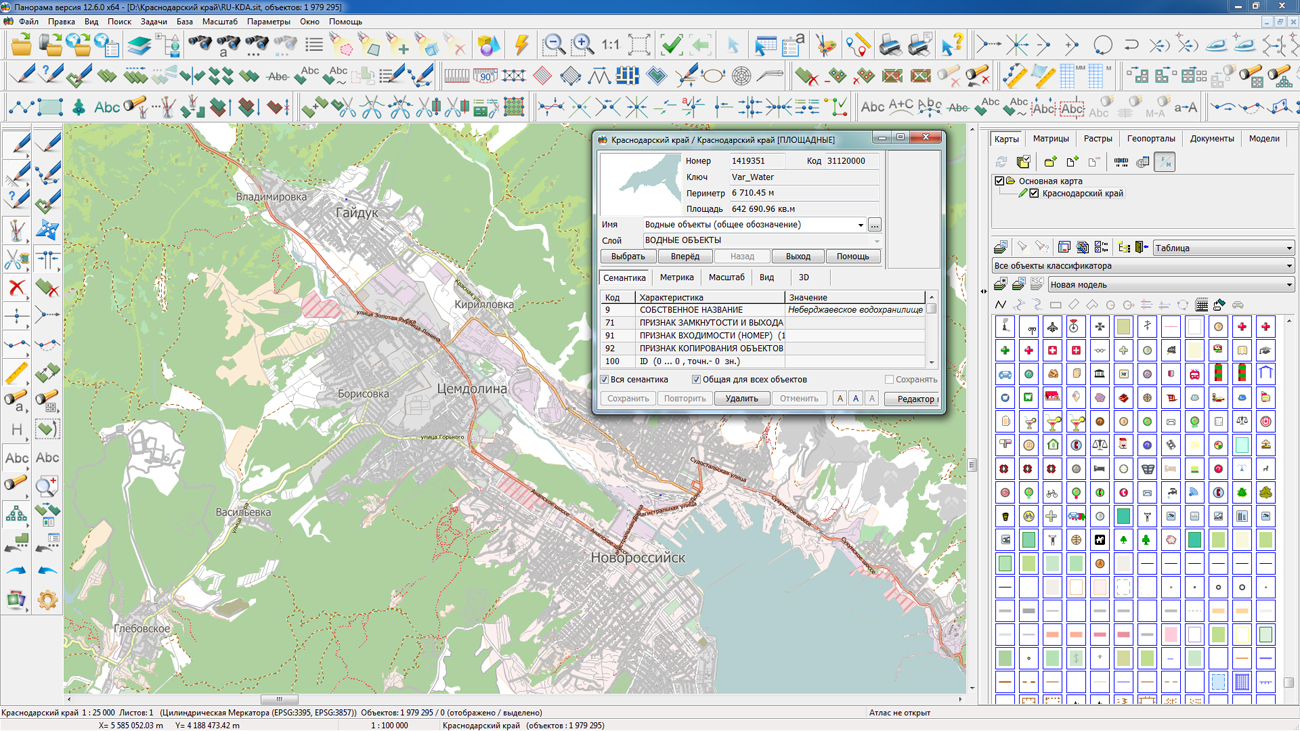
In KB "Panorama" the version 11.13.11 is developed for operating system Astra Linux Special Edition (Release "Smolensk"). In the new version the mode of drawing objects onto vector maps is improved. Geodetic coordinates of objects can be specified in radians, degrees or in degrees, minutes and seconds. By means of the advanced "Map contents" dialog, the user for each map individually sets the visibility, the ability to edit and select an object. This allows at the displaying to focus on individual maps and excludes the possibility of their random editing.
The mechanism for saving user's session settings has been improved. Now the parameters file is written not into the temporary directory of the system, but into the user's home directory. This allows you to save the settings after rebooting the system and to differentiate the sessions of the individual users. The convenience of working with the dialogs "Map print", "Label options", "Matrix builder" has been improved. In the dialog "Create object" the checking of entering an incorrect metric is extended. Displaying objects of operational situation in accordance with the CEUZ is refined.
GIS "Operator" is an universal domestic geoinformation system for power structures. The program is intended for accumulation, the storage, the automated processing and displaying the data, results of calculations and the forecasts having a geospatial binding. GIS "Operator" contains tools for displaying and processing vector, raster and matrix maps. The application provides users with tools for solving specialized tasks of modeling the movement of special objects against the background of 3D model, a forecasting the consequences of emergencies on hazardous objects, a monitoring the movement of aircraft, a performing the geodetic and topographic work, processing data from GPS/GLONASS navigation devices, a printing the displayed spatial data to various output devices and many others. GIS "Operator" SE is certified by the 2nd level of control of the absence of undeclared capabilities in the RF Ministry of Defense.
The new version of the program is available for download in the section.


On the geoportal , the map of Krasnodar territory, formed according to OpenStreetMap data, was updated. Source data obtained from the website are complemented by objects from maps of scale 1: 1 000 000. There are added the objects of hydrography, vegetation, road network. For work with the received maps it is possible to use the program of or other software products of KB "Panorama".
Publishing of updates in bank of spatial data is made by using the program of . Publishing contents of bank of spatial data on the geoportal and data access for downloading are implemented by means of GIS WebServer SE.
Free maps on the basis of OpenStreetMap data are available for download on the page "Digital maps and images".


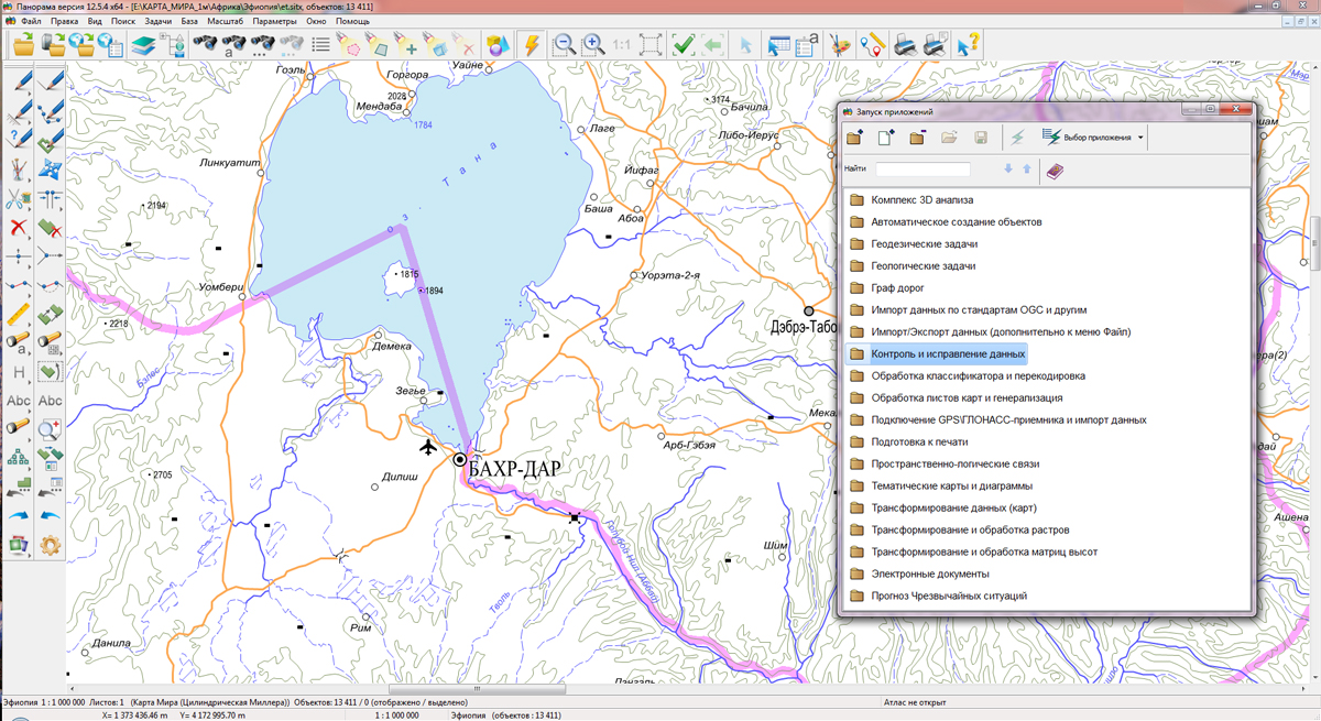
KB "Panorama" prepared a digital geographical map of scale 1: 1 000 000 in format SXF for the Federal Democratic Republic of Ethiopia. obtained according to information from the website has served as source for map's preparation.
The map contains information about the quantity of inhabitants for cities and the names of settlements in Russian. As additional materials the World Map of scale 1: 5 000 000 and data of were used. The map is led to the classifier of geographical maps of scale from 1: 1 000 000 (1mogk13g.rsc). It can be used for the general estimation of the terrain and studying of an environment, an ensuring of educational process, as a basis for creation of geographical maps of smaller scale, thematic and special maps and solving other tasks.
The map is distributed free according to the free . Digital geographical map of scale 1: 1 000 000 in format SXF is available for downloading on page "Digital maps and images".


version 2.6 was developed in KB "Panorama". In the new version the tools of satellite monitoring of fields support the viewing of the vegetation indices CVI and EVI. The ability to accumulate the results of building zoning maps is added.
The CVI index (vegetation index of chlorophyll) has an increased sensitivity to the chlorophyll content in the foliage and is used from the beginning to the middle of the crop growth cycle. The EVI (Advanced Vegetation Index) index is used to assess the variability of development of crops in the growth stage with high biomass. Zoning maps are a synthesis of selected vegetation maps and soils on the basis of satellite images of high accuracy (10 m and 30 m) at different periods and under different climatic influences, which in turn determine the sustainably allocated agronomic zones on the field. Analyzing archival satellite imagery of past seasons, a potentially possible distribution of plant biomass is modeled. Zoning maps can identify problem areas on the map of fields, develop measures to increase productivity, and accurately predict crop yields.
The collection and processing of satellite imagery for satellite monitoring's data is carried out by Geosys company. Data of satellite monitoring is loaded from web service of the company and is accumulated in information base the with a binding to a field's contour. The data obtained make it possible to understand the true cause of the problems of each field and to promptly influence the growth of plants throughout the season. In GIS WebServer AGRO, the viewing and analysis of vegetation indexes matrixes from a single agricultural enterprise base has been expanded and structured. As a source of spatial data, GIS WebServer AGRO uses the multiplatform cartographical service . Data exchange with the service is performed according to international open standards OGC: WMTS, WMS, WCS and WFS. The maps placed on the can be a source of the data for service the GIS WebService SE. The map layers published from the server reflect the current state of the spatial data base in the time mode close to the real one.


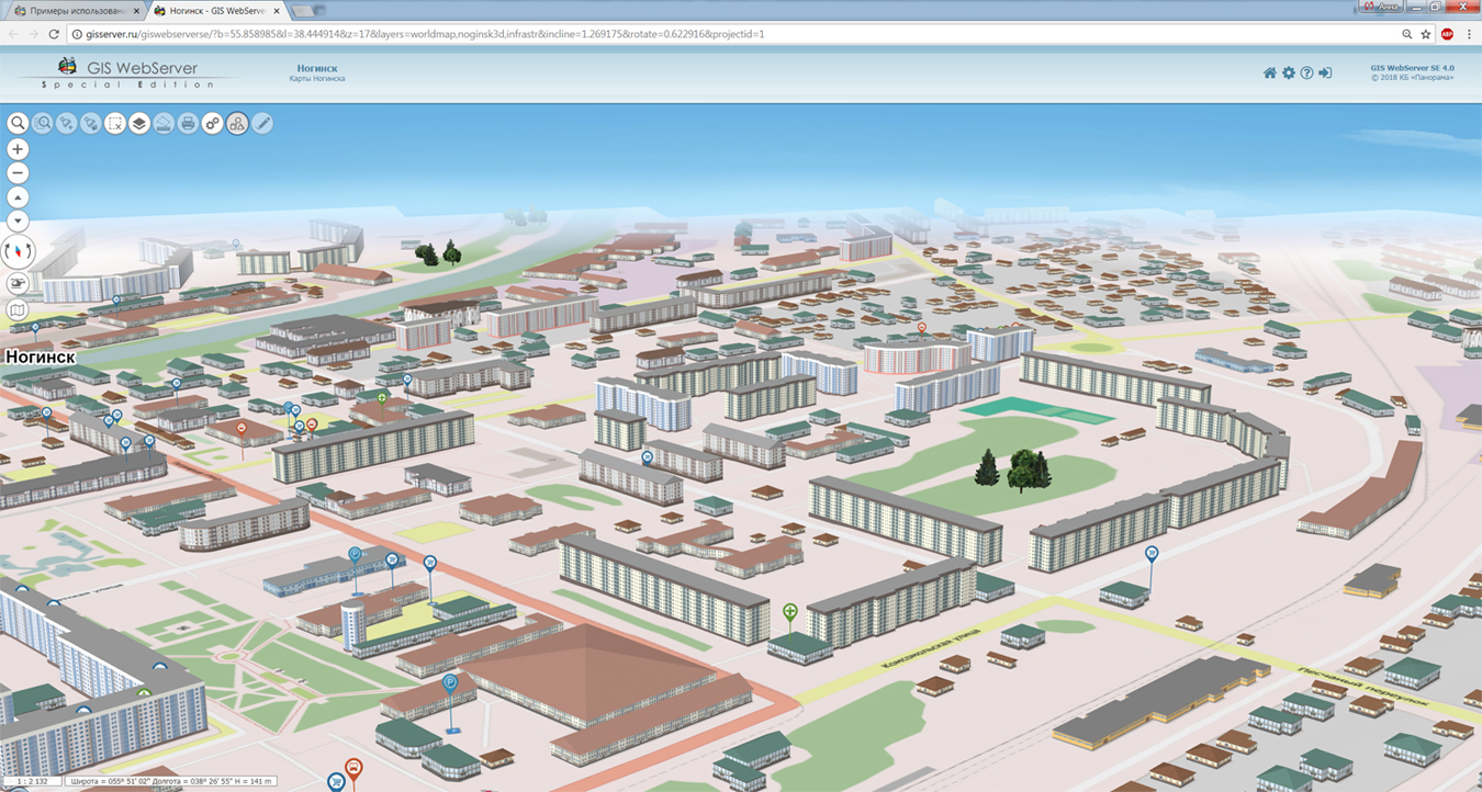
4.0 is developed in the KB "Panorama". In the new version of the program in 3D map, the display of symbols from textures containing several complex images is accelerated, types of three-dimensional signs (different types of roofs) are expanded. There is added the ability to go to the center of the model through the Map Contents. The transition is performed by moving along a parabolic trajectory.
In the map editor the mode of a merge of two identical map objects is added and the interface of the user is updated. At address search and search in Rosreestr for an address point the information on object is displayed at pointing the cursor of the mouse. Search by area is extended by the mode of manual input of the coordinates of the search area for more accurate selection of objects.
Possibilities of "Manager of map project " are expanded. The manager provides the ability to select data from the virtual folder of the map's project and update the composition of the map data layers according to the selection. The administration module has been updated. There is added the setting of permissions to use the project manager for the user groups.
The toolkit of developing the Web-applications the GIS WebToolKit SE has been improved, which expands possibilities of GIS WebServer SE and can be integrated into other information systems. Access to data (images, vector maps and terrain information) is provided by Web services using common OGC protocols and ISO standards. Service the GIS WebService SE (OGC WMS/WMTS) provides spatial information in the form of graphic images. Various types of high-altitude data are used as a digital elevation model: matrixes (in the formats SRTM, GeoTIFF, IMG, MTW), TIN-models, point cloud and others. At request the most accurate data onto a specified terrain site with a given resolution is automatically sampled. To transfer data of the digital terrain model to the Web, the WCS protocol is used. The relief data is represented as tiles and cached on the client.
As a source of spatial data, the can be. It provides the collection, storage, search and delivery of spatial data in exchange formats, a displaying the state of the data bank in the form of maps-schemes, the automated formation and updating of geo-covers.
GIS WebServer SE is used in the construction of closed corporate systems to ensure the protection of data having a security classification or a trade secret. GIS WebServer SE is certified for Level 2 of absence of undeclared capabilities. The new version of the program expands the application's capabilities in solving problems of analysis, management and long-term planning of the territories development. GIS WebServer SE is implemented using the toolkit of GIS WebToolKit SE, which can be used in development tools that use the JavaScript.
The new version of the program is available on the website in the section.


Ph.: +7 (495) 739-0245, +7 (925) 221-1603
www.gisinfo.ru | panorama@gisinfo.ru
105005, Russia, Moscow, Baumanskaya Street 7, building 1, office 229 (m. Baumanskaya)
Copyright © Panorama Group 1991 - 2024


 Mobile version
 Full version