Copyright © Panorama Group 1991 - 2024

In KB "Panorama" the version 12.5.0 for the x64 platform is developed. In the new version of the program the tools for import and visualization of spatial data are updated. In the converter of digital vector maps from SHP format there is added a support of import of a folders tree with SHP files, with the automatic formation of sheets and map layers in national division and coordinate systems, with the assignment of conventional symbols by alphanumeric code in any national language encoded in UTF. The task "Import of navigational data from GPX files" is improved. The program allows to load simultaneously several files in format GPX onto one map. This will save operator time on converting data.
Support of local database SQLite for display of raster data in the form of tiles is implemented. There is added a restriction of the displayed geoportal area, set by the user in the settings file wmslist_en.xml. Support of local SQLite database provides also display of the matrix data about terrain in the hmp format and the execution of all kinds of computational tasks related with heights (construction of profiles, visibility zones, estimation of elevation, calculation of ground volumes, 3D modeling and other tasks). There is added a support for zip archives, encrypted by a user password, at performing the operations of opening the data sets (vector maps, images, matrices) and updating the open data. If the zip archive is encrypted, the user will be prompted to enter a password to access the data.
The task of "Map Editor" has been improved. New objects are located on the map at once, taking into account the order of the layers displaying specified in the classifier, without additional sorting of the map. To manage the order of recording objects on the map when sorting the map, a service file with the SIN extension is formed. If the SIN file was not created, then the objects are written to the map in the order of their type (polygon, linear, etc.). The mode "Creation of group of objects by coordinates from a text file" is modified. There is added the possibility to build orthodrome by the coordinates of the file MET - an arc on the Earth's surface, passing through the shortest distance between the given points. To execute the task in a text file with the .MET extension, you need the presence of the #ORTHODROME service field and two lines with the coordinates of the starting and ending points of the created object - the arc. At large distances (thousands of kilometers), the points of the arc are formed with a step of no more than 0.4 degrees, for small distances - no more than 10 kilometers, which ensures the determination of lengths and angles with triangulation accuracy of 1 class.
New property "Save time and date of object update" is added in the dialog of creating a new map. If the map is created with the specified property, then into each object, when creating and editing, service semantics are automatically recorded with the date and time of the performed operation and with the name of the operator that performed the operation. The specified property can not be disabled. Support of the pseudo-conical equal-projection of Bonn (EPSG:9827) is added. The new projection can be selected for maps of the Geographical type.
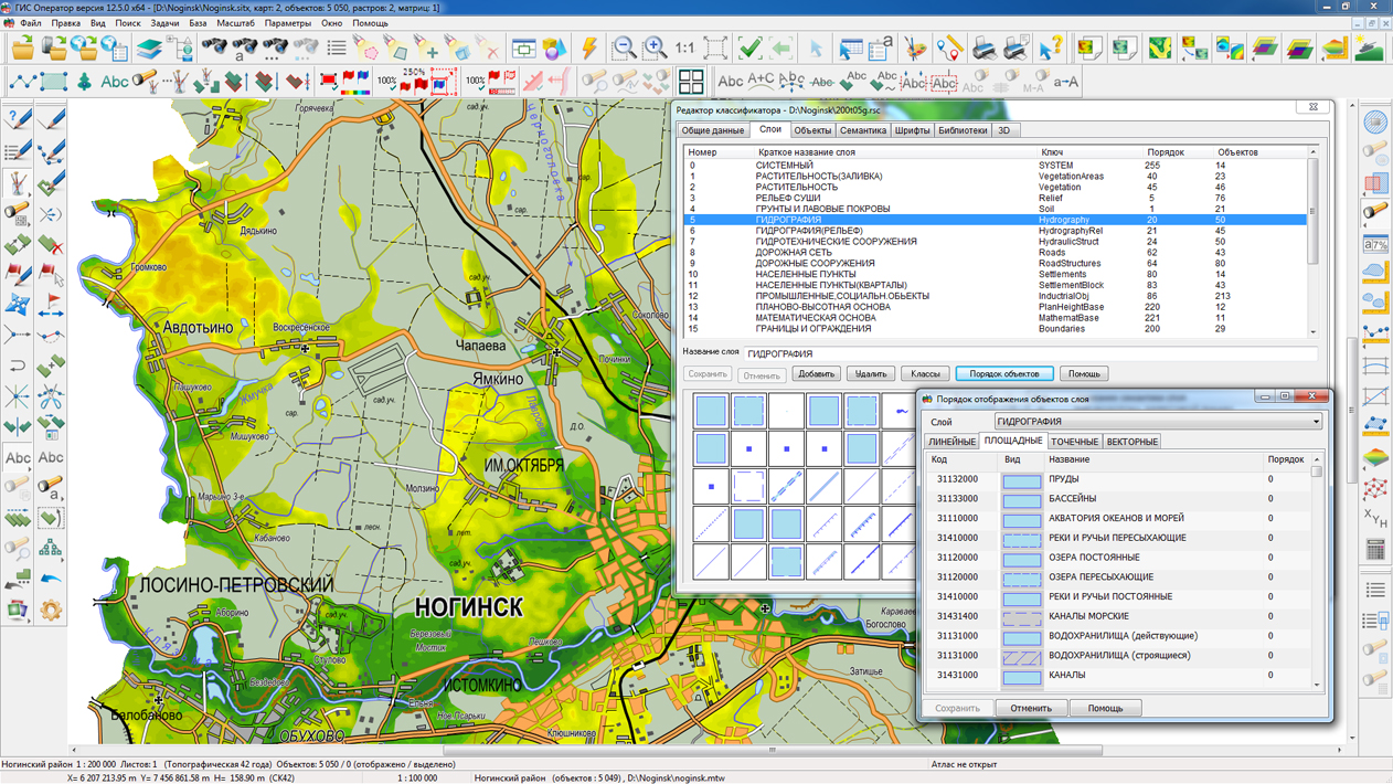
In the "Classifier Editor" in the "Layers" bookmark, there is added the ability to set the order of displaying objects within a given layer (the button "Objects order"). It allows to unite layers of the same-type in the classifier which have been entered earlier for management of order of objects display. Flexible setting of the classifier simplifies the preparation of libraries of conventional symbols according to the requirements adopted in the national mapping systems of different countries. There is added the accounting for multipolygons when searching for objects by a given area, taking into account the occurrence, intersection, location at a given distance.
XML format is used for storage of conditions of search and display of map objects in files with "vclx" extension in the "\Log" folders. This simplifies the work with program settings from external applications. The dialogue "Select object" is refined. On the "Metric" bookmark a map window has been added with the ability to display the section with the current point of the object's metric. This allows you to view the contours of extended objects and to correct the coordinates of points without leaving the dialog.
Due to multi-threaded processing on a multi-core processor, the execution time of operations on lists of objects is reduced by 6-8 times - a search for intersections, occurrences, location at a given distance, and so on. Speed of constructing the list of the found objects is increased in 2-3 times. The sorting of multi-sheet maps (MAP) is accelerated by 3-4 times. When sorting map objects, the order of displaying objects in the layer is taken into account.
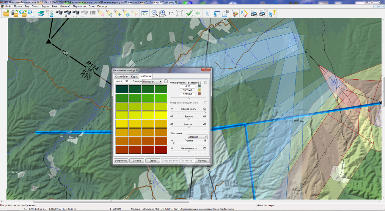
In the program the dialog "Image color adjustment" was refined, which is called via the menu item "Options\Colors" in tasks of "Data lists" or "Map legend". There is implemented the possibility of creating and editing a set of the user palettes to control the displaying the matrixes of terrain elevation that were added into the document.
The new version of the program is available for download in the section.


In KB "Panorama" the of version 12.5.0 for power structures is developed. The program provides support for a single geoinformation space based on building a network architecture managed by spatial data servers () and application servers (). As a source of geospatial data the can be applied.
In the new version, the speed of requesting and updating data from the GIS Server has been increased for providing collective work in a network with maps of the terrain and operational situation for the planning and management of troops and weapons. The ruler of sources of the data has been expanded that are used for formation of terrain elevation matrixes and execution of computational tasks related with heights (construction of profiles, visibility zones, estimation of elevation, calculation of ground volumes, 3D modeling).
The task "Navigator 3D" is refined. Into it the new mode "Cloud of points" is added which provides displaying the data of laser scanning of terrain in three-dimensional model. As one of sources of the data of laser scanning, the dense digital model of a surface is used that was created by software of the company. The model, calculated on the basis of many types of input data using the method SGM (Semi-Global Matching), simplifies the creation of three-dimensional urban high-resolution models and can be loaded into the GIS "Panorama" for displaying in two-dimensional and three-dimensional form, vectoring, constructions of profiles and execution of other calculation tasks. The digital model of a surface comes in LAS-files. The data of the terrain's laser scanning is downloaded from LAS-files and stored as MTD-models.
The new "Cloud of points" mode allows you to display in a three-dimensional form a cloud of points of any volume. If the points have not only high-altitude, but also the color data, this data is also used for 3D-displaying. Otherwise, the model is displayed in the colors of the altitude palette. The model of a cloud of points can be displayed in the original form or its data are included into the terrain mapping.
In the new version of the program the converter of digital vector maps from SHP format has been improved. It supports the import of a folders tree with SHP files, with the automatic formation of sheets and map layers in national division and coordinate systems, with the assignment of conventional symbols by alphanumeric code in any national language encoded in UTF.
In the "Classifier Editor" in the "Layers" bookmark, there is added the ability to set the order of displaying objects within a given layer (the button "Objects order"). It allows to unite layers of the same-type in the classifier which have been entered earlier for management of order of objects display. Flexible setting of the classifier simplifies the preparation of libraries of conventional symbols according to the requirements adopted in the national mapping systems of different countries.
The sorting of multi-sheet maps (MAP) is accelerated by 3-4 times due to multi-threaded processing on multi-core processors. When sorting map objects, the order of displaying objects in the layer is taken into account.
The task "Import of navigational data from GPX files" is improved. The program allows to load simultaneously several files in format GPX onto one map. This will save operator time on converting data.
In the program the dialog "Image color adjustment" was refined, which is called via the menu item "Options\Colors" in tasks of "Data lists" or "Map legend". There is implemented the possibility of creating and editing a set of the user palettes to control the displaying the matrixes of terrain elevation that were added into the document.
The new version of the program is available for download in the section.


In KB "Panorama" the of version 3.5 is developed. The new version optimizes the loading of a large number of materials into the data warehouse. There is added a mode of placing into the data warehouse without downloading via the HTTP protocol, the data is downloaded from the local folder. Two download modes are supported: remote downloading of data sets via HTTP protocol and download over the local network from the available device. Downloading over the local network provides a one-time placing of a large amount of data into the data warehouse and a higher filling rate of the Data Bank.
Security is increased when working with the database, work with the database is implemented through a separate account with limited rights.The rights to access the data and functionality of the complex are assigned to users in accordance with the rights of the groups to which they belong. There is expanded the list of metadata fields for maps and remote sensing data, which are automatically filled when materials are placed into the data warehouse. The mode of search and selection of materials is optimized, the ability to manage the list of displayed fields is added to the search tools. The system of the help on work with a complex is realized.
The data bank of digital maps and remote sensing data is intended for building a cloud data warehouse of spatial data, providing access to these data, the automated generation and updating of geo-covers. Provides gathering, storage, search and delivery of spatial data in exchange formats, displaying a status of a databank in the form of maps-schemes. Maps-schemes are conducted for each type of stored data: vector maps, remote sensing data, matrixes of heights and terrain models. It provides remote placement of sets of spatial data into file data warehouse, conducting versions of stored sets, update of data availability maps-schemes, the automated collection and formation of metadata, automated formation and updating of geo-covers. Automated collection and formation of metadata is performed according to the standards of ISO 19115: 2003, Geographic information - Metadata and ISO/TS 19139, Geographic information - Metadata - XML schema implementation. The reduced copies of data images are automatically formed, the checksum of files and completeness of data sets are verified.
The reference to the Databank and data exchange is carried out via the web-interface. The program can work in operating systems with the closed contour where processing of protected data is carried out. The databank includes applications the and that are certified to Level 2 of undeclared possibilities in system of certification of means of the information protection of the Ministry of Defence of the Russian Federation. For conducting base of the metadata there are used the DBMS PostgreSQL (OS Windows, Astra Linux SE), DBMS Zarya (OS Zarya-data processing center).
The complex includes the module of administrating the Bank of Digital Maps and Remote Sensing Data. It provides customizing the general parameters of the application's work, customizing the parameters of metadata base, a choice of formats of storage and the composition of groups of stored files, types of objects for maps-schemes, conducting the groups of users and assigning the rights of users for access to the data and allowed actions. Users of desktop programs the , and others can connect to Bank of metadata through the GIS Server for work.
The new version of the program is available for download on the page.

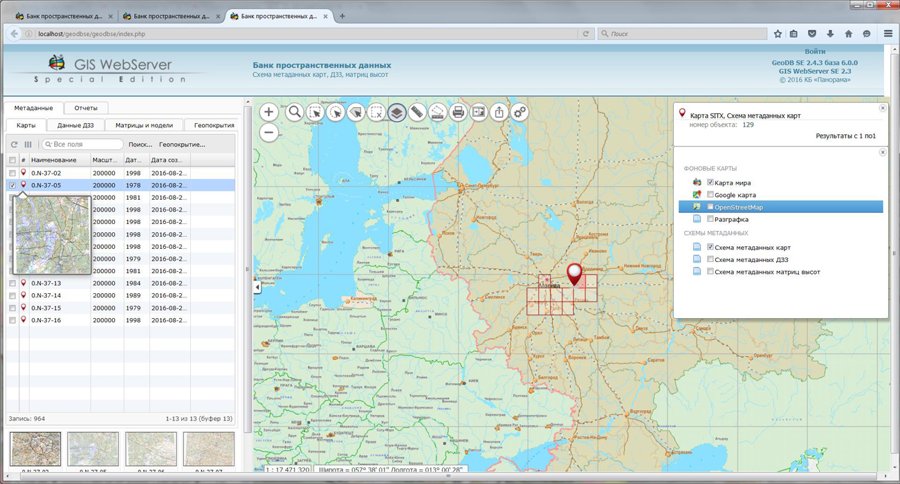


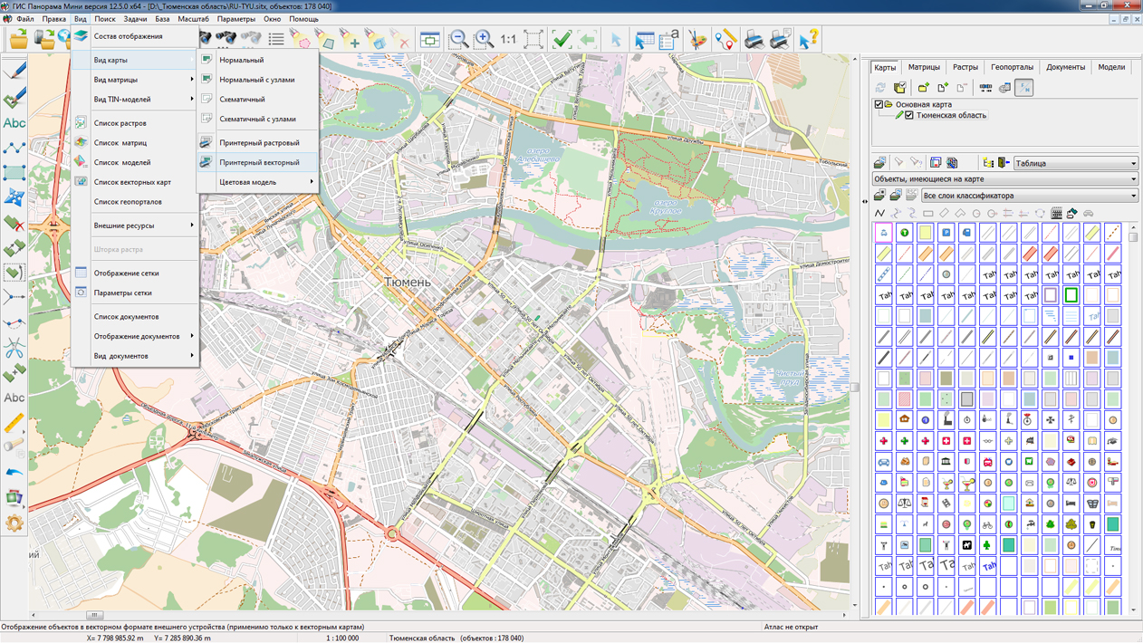
On the geoportal , the map of the Tyumen region, formed according to OpenStreetMap data, has been updated. Source data obtained from the website are complemented by objects from maps of scale 1: 1 000 000. There are added the objects of hydrography, vegetation, road network. For work with the received map it is possible to use the program of or other software products of KB "Panorama".
Publishing of updates in bank of spatial data is made by using the program of . Publishing contents of bank of spatial data on the geoportal and data access for downloading are implemented by means of .
Free maps on the basis of OpenStreetMap data are available for download on the page "Digital maps and images".


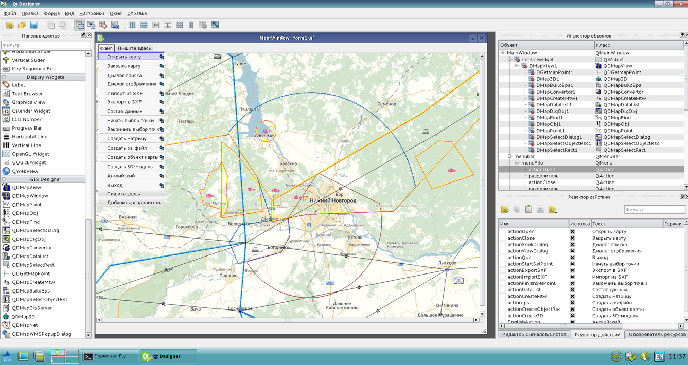
In KB "Panorama" the GIS Constructor of version 12.0.3 is developed for operating system Astra Linux Special Edition (release "Smolensk"). The new version is adapted to work with the Qt framework version 5.5. This enables developers to create modern user interfaces with use of Qt QML and Qt Quick modules in combination with high-speed digital data access logic implemented on the basis of C ++ and the MAPAPI interface. By using the combination of Qt Location module for obtaining geographical coordinates and access interfaces to digital data the GIS Constructor extends a set of data sources for creating and updating maps.
The source texts of GIS applications written with using the software product the GIS Constructor and Qt framework are cross-platform and can be used for assembly for a wide range of devices: desktop, mobile and embedded. Adaptation of existing GIS applications for work with new versions of GIS Constructor and Qt require a minimum of efforts due to preserving the interfaces of the graphic components of the GIS Constructor and the interface for accessing digital MAPAPI data. The graphical components of the program are adapted for use with the new version of the environment for the development of graphical interfaces of Qt Designer.
GIS Constructor implements support for a single geoinformation space managed by spatial data servers () and application servers (). Due to the ability to work with the GIS Server, users of GIS applications can directly connect to geospatial data bases, view and edit tables in the form of maps in the specified conventional symbols. Support for interaction with GIS WebService SE allows to get access to spatial data according to international standards OGC WFS, WFS-T, WMS, WMTS, WCS.
GIS Constructor supports various coordinate systems and projections, provides ample opportunities for creating and adding of user conventional symbols. Visualization of the contents of digital maps is made in conventional symbols adopted for topographic, geographic, cadastral and other types of maps.
The new version of the program is available for download in the section.


Ph.: +7 (495) 739-0245, +7 (925) 221-1603
www.gisinfo.ru | panorama@gisinfo.ru
105005, Russia, Moscow, Baumanskaya Street 7, building 1, office 229 (m. Baumanskaya)
Copyright © Panorama Group 1991 - 2024


 Mobile version
 Full version