Copyright © Panorama Group 1991 - 2024

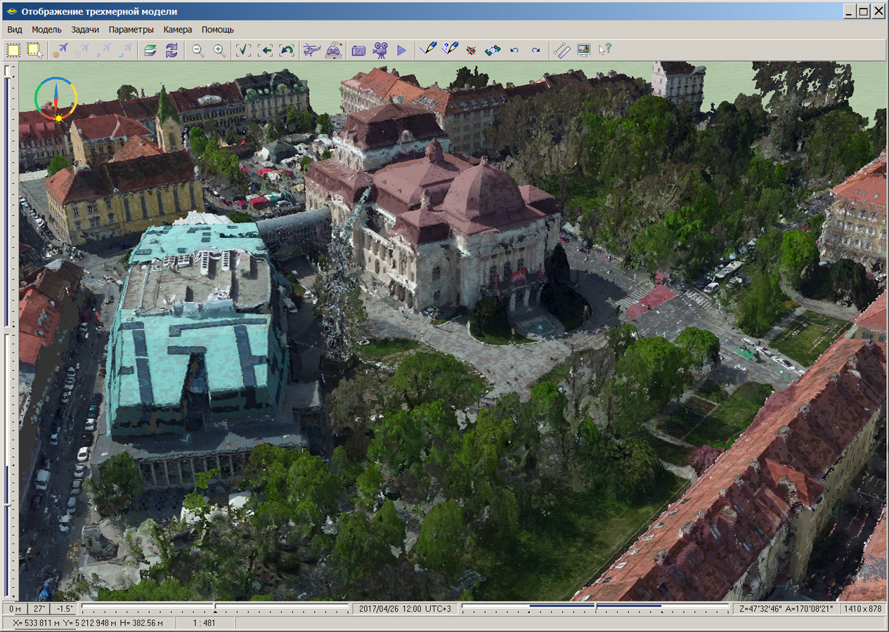
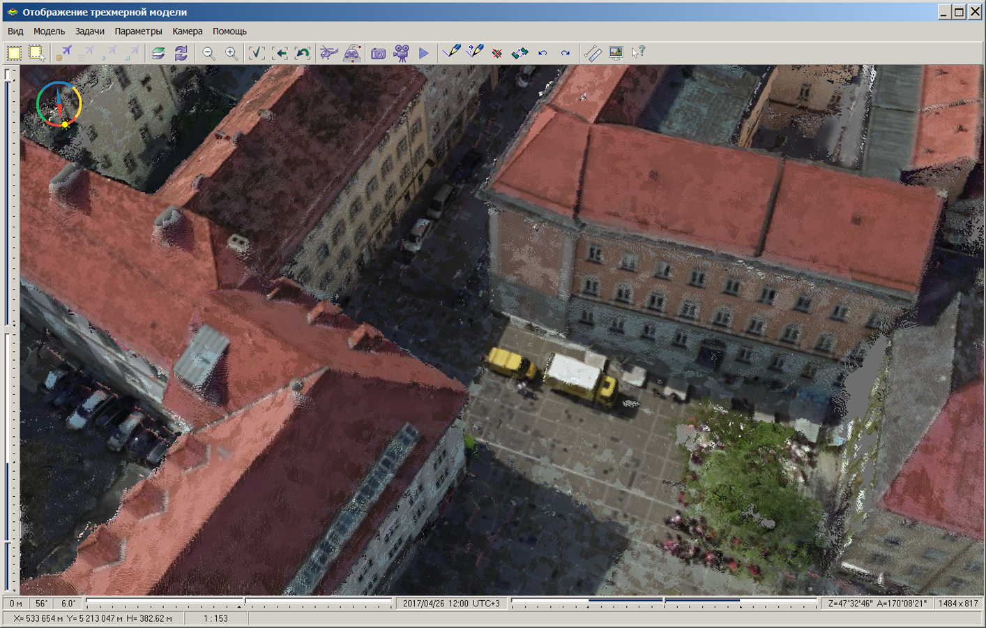
In KB "Panorama" the is developed. In the new version of the program, the task "Navigator 3D" is refined. Into it the new mode "Cloud of points" is added which provides displaying the data of laser scanning of terrain in three-dimensional model. As one of sources of the data of laser scanning, the dense digital model of a surface is used that was created by software of the . The model, calculated on the basis of many types of input data using the method SGM (Semi-Global Matching), simplifies the creation of three-dimensional urban high-resolution models and can be loaded into the GIS "Panorama" for displaying in two-dimensional and three-dimensional form, vectoring, constructions of profiles and execution of other calculation tasks. The digital model of a surface comes in LAS-files. The data of the terrain's laser scanning is downloaded from LAS-files and stored as MTD-models.
The new "Cloud of points" mode allows you to display in a three-dimensional form a cloud of points of any volume. If the points have not only high-altitude, but also the color data, this data is also used for 3D-displaying. Otherwise, the model is displayed in the colors of the altitude palette. The model of a cloud of points can be displayed in the original form or its data are included into the terrain mapping.
In the task the "Automated generalization of topographic maps" a new mode "Setting the range of roads visibility" was added. This mode is designed to simplify an overloaded road network at transition to smaller scales of maps. At compression of the map image the density of objects per unit of the area of a map increases. Linear objects of the road network begin to paint each other and adjacent polygonal map objects (blocks and industrial objects). The new mode allows you to save all objects of the road network, including streets and driveways in the derived map. The task is designed for processing topographic terrain maps in the scale from 1:25 000 up to 1: 1 000 000. This method allows to realise the multiscale maps providing the qualitative image in several scales, and also to raise degree of automation of processes of drawing up and the issuing maps of smaller scales.
The converter of digital vector maps from SHP format has been improved. It supports the import of a folders tree with SHP files, with the automatic formation of sheets and map layers in national division and coordinate systems, with the assignment of conventional symbols by alphanumeric code in any national language encoded in UTF.
In the "Classifier Editor" in the "Layers" bookmark, there is added the ability to set the order of displaying objects within a given layer (the button "Objects order"). It allows to unite layers of the same-type in the classifier which have been entered earlier for management of order of objects display. Flexible setting of the classifier simplifies the preparation of libraries of conventional symbols according to the requirements adopted in the national mapping systems of different countries.
The sorting of multi-sheet maps (MAP) is accelerated by 3-4 times due to multi-threaded processing on multi-core processors. When sorting map objects, the order of displaying objects in the layer is taken into account.
The complex of geodesy calculations is improved. There is implemented the storage and editing of data on documents that establish the category of land, the type of permitted use and the address of land use not only for the formed, but also for the specified, changeable and original sites. Screen elements are added for entering and editing information about a natural object. The procedure for analyzing the initial data specified by the user for the formation of the scheme for the location of the land plot on the cadastral plan of the territory was automated.
The task "Import of navigational data from GPX files" is improved. The program allows to load simultaneously several files in format GPX onto one map. This will save operator time on converting data.
The program has refined the dialog "Image color adjustment", which is called via the menu item "Options\Colors" in tasks of "Data lists" or "Map legend". There is added the possibility of creating and editing a set of the user palettes to control the displaying the matrixes of terrain elevation that were added into the document.
In the task of "Check of vector map quality" the output of report documents into the HTML-file is added. Outputting reports into HTML file allows you to generate reporting documents without using office programs. There is added the ability to run several instances of GIS "Panorama" for execution of control of various vector maps with the issuance of reports into HTML format (a report into MS Word is executed only from one program).
The new version of the program is available for download in the section.


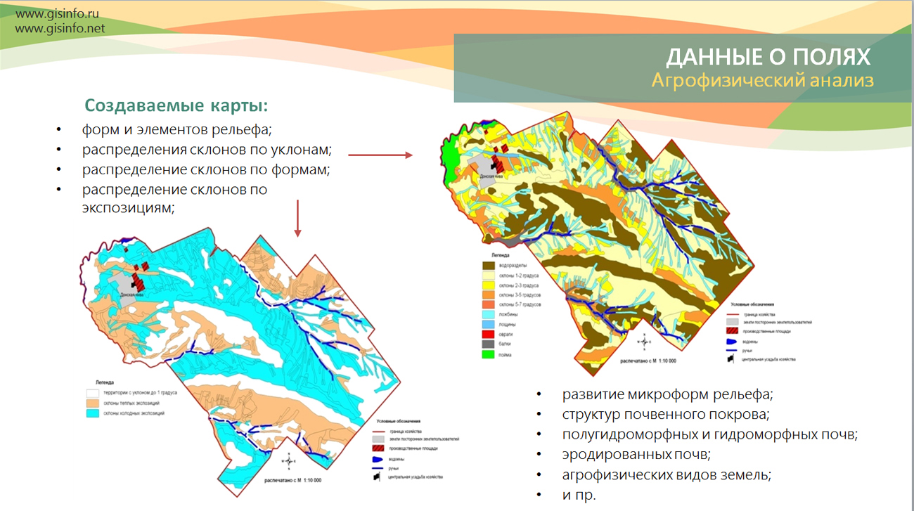
Specialists of KB "Panorama" updated educational and presentation materials on work with agrarian geoinformation systems: , , , "Workstation of Agronomist", Panorama AGRO Service and GIS WebServer AGRO. The basic software for creating the geographic information system of the agro-enterprise is the GIS Panorama AGRO. It provides accounting of agricultural lands, maintenance of the soil fertility base, agro-technological planning of agriculture, monitoring of the status of fields and crops, maintenance of a database of information on vehicles, agricultural machinery and aggregates. It provides remote monitoring of mechanized operations based on GLONASS/GPS navigation of technical facilities and information interaction with external programs, including products on the 1C platform.
The use of software solutions from the , as well as their combination with a cartographical server () and , allow building scalable distributed information systems that provide a single geographic information space for the agro-enterprise.
You can get acquainted with the on the application of agro-geoinformation systems in the section.


On the geoportal , the map of the Chelyabinsk region, formed according to OpenStreetMap data, has been updated. Source data obtained from the website are complemented by objects from maps of scale 1: 1 000 000. There are added the objects of hydrography, vegetation, road network. For work with the received map it is possible to use the program of or other software products of KB "Panorama".
Publishing of updates in bank of spatial data is made by using the program of .
Publishing contents of bank of spatial data on the geoportal and data access for downloading are implemented by means of .
Free maps on the basis of OpenStreetMap data are available for download on the page "Digital maps and images".


The list of public data in SXF format on the geoportal is supplemented with a map to the territory of Berlin at a scale 1: 25 000. The map is formed from the initial data of OpenStreetMap obtained from the site . For work with the map it is possible to use the program of or other software products of KB "Panorama".
Publishing of updates in bank of spatial data is made by using the program of . Publishing contents of bank of spatial data on the geoportal and data access for downloading are implemented by means of .
Free maps on the basis of OpenStreetMap data are available for download on the page "Digital maps and images".


version 9 is developed in KB "Panorama". To build corporate, regional, departmental geoinformation systems, it is necessary to use large amounts of information (Big Data). These systems should work in a single geoinformation space, monitor changes in territories and display them promptly. To this end, a new version of the ImageryCreator program was developed to publish large amounts of information in the form of Big Data tiles. It allows you to use all resources of a multi-core server. By distributing the load across the threads, ImageryCreator allows you to cut the tiles several times faster. Thus, the time for creating huge data sets in tens of terabytes is shortened from a few days to several hours.
The program can work at once with several data projects. The parameters of each user's work are saved separately. The program allows to create several pyramids of tiles which can have different formats, scales and types of matrixes. ImageryCreator and have a single structure of the settings file. This allows to simplify the process of data administration, to make a technological chain (ImageryCreator - - ) for publication of the spatial data more simple and understandable.
The program allows you to create tiles in JPEG and PNG formats according to the international standard OGC WMTS 07-057r7 version 1.0.0. The tile data generated by the ImageryCreator program are used by software the GIS WebServer SE, GIS WebService SE to provide high-speed query execution for displaying spatial data over large areas while simultaneously accessing a large number of users.
A new version of the program is available on the page.


Ph.: +7 (495) 739-0245, +7 (925) 221-1603
www.gisinfo.ru | panorama@gisinfo.ru
105005, Russia, Moscow, Baumanskaya Street 7, building 1, office 229 (m. Baumanskaya)
Copyright © Panorama Group 1991 - 2024


 Mobile version
 Full version