Copyright © Panorama Group 1991 - 2024

In KB "Panorama" the tools of version 12.4.0 is developed for creation of GIS applications in Delphi, C ++ Builder Embarcadero. In the new version there are updated the GIS-kernel libraries in which possibility is added for saving the vector data from the format of GIS Panorama into GeoJson format with taking into account the styles of displaying. In this case, into the file not only the geometry of objects is saved, but also their metadata and external view. The output file can be published in web by means of leaflet, openlayers, 2gis, openstreetmap and other applications supporting GeoJson with styles.
In the dialog box "Select object" there is changed the algorithm for calculating the area of the objects having extent on a longitude more than 5 degrees. Extended objects are cut by strips in UTM projection, no more than 5 degrees on a longitude. The total area of objects is calculated by conventional zones and summed. The extended accuracy of calculation of the area is provided at a selecting the "Extended" value in the pop-up menu for item "Accuracy of coordinates display".
Converter from SHP format is improved. There is added support for file names, field names and attribute values in the national encoding. There is added an automatic identification of a set name and an object of the classifier (by key or name).
There is added the ability to create a new classifier with the subsequent primary automatic classification of objects and characteristics (automatic addition into the classifier of absent semantics and types of objects). Displaying rasters with cutting the images by a frame is improved. Accuracy of the image cut for different scale display is improved. It allows at scaling to display more precisely a mosaic of rasters without discrepancies and imposing the images of the adjacent rasters. New implementation of forming the images of the reduced raster copies allows to improve details of the compressed image.
Possibility is added for opening of rasters from which are generated from GeoTIFF format without copying the image into RSW file (multispectral multichannel rasters displayed through the GDAL library).
There is increased the speed of building the reduced copies of raster images after import of graphic files or procedures of data compression. Time of building the pyramid of reduced images inside RSW file is reduced by 10-15 times at the expense of multi-threading processing on multi-core processors.
On an order there are accelerated the operations of viewing and the printing the transaction log (the list of the operations executed on a map) for a great number of records (hundreds of thousands or more) through the use of indexed transaction log. There is added a support of advanced parameters of local coordinate systems for execution of affine transformation or conversion of type "shift, scale, rotation". The use of advanced parametres increases the accuracy of the coordinates calculations in the local coordinate systems, allows you to apply professional geodetic programs for high-precision calculation of the parameters for the local area on the basis of projections of Gauss-Kruger, UTM, Stereographic and others.
GIS ToolKit is a toolkit for developer of geographic information systems, allowing to process spatial databases. The toolkit consists of a set of visual components (available in the source code) and API functions for direct access to the database of geodata. Database of geodata can be located either in the workplace (direct access to the data), and on the local network or in the Internet (using the components of access to the GIS Server or a data exchange according to international protocols WMS, WFS, WCS, WMTS).
New versions of software are available for download on the page.

In KB "Panorama" the version 8.2.2 is developed. In the new version of the program the speed of transformation and creation of tiles by raster and matrix data is increased. The acceleration is achieved by balancing the load across multiple cores of system. It also allows to reduce time for data preparation at formation of project in ImageryCreator. For the purpose of increase in productivity of the server and displaying the data in GIS WebServer SE there is added a support of tiles with the sizes of 512х512 pixels for the raster and matrix data and of 1024х1024 pixel for vector maps.
The program allows you to create tiles in JPEG and PNG formats under the international standard OGC WMTS 07-057r7 version 1.0.0. Tile data formed by the program are used by software products the , for providing the high speed of execution of requests for display of the spatial data on large territories at the simultaneous handling a large number of users.
The new version of the program is available on the .
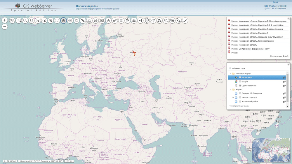


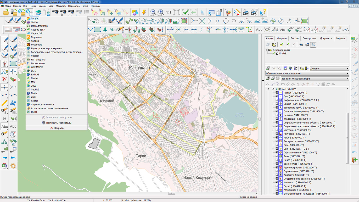
Geoportal updated the maps of Dagestan, Ingushetia and the Chechen Republic formed according to OpenStreetMap data. Source data obtained from the website are complemented by objects from maps of scale 1: 1 000 000. There are added the objects of hydrography, vegetation, road network. For work with the received maps it is possible to use the program of or other software products of KB "Panorama".
Publishing of updates in bank of spatial data is made by using the program of . Publishing contents of bank of spatial data on the geoportal and data access for downloading are implemented by means of .
Free maps on the basis of OpenStreetMap data are available for download on the page "Digital maps and images".


In KB "Panorama" the "Workstation of agronomist" version 12.4.1 is developed. In the new version "Complex of Agronomical Tasks" is adapted for operation in the 64-bit Windows system.
There is optimized the operation of the complex for the size of memory when you open vector maps and remote sensing data of large volume.
Agronomical audit of agriculture is necessary in order to analyse activities of agricultural enterprises of any scale, from small farmers to large agricultural holdings with the objective of optimizing the regular costs and eliminating the errors in the organization of the economy.The use in "Workstation of agronomist" for the platform x64 of all available RAM can speed work with maps of a large amount in the tasks of displaying spatial data, the search and selection of map objects based on user-selected criteria, when editing large arrays of selected objects. There is supported the work with rasters and matrixes of heights of large volumes and data of geoportals which can be displayed together with the vector map.
Into the "Reports" panel the "Control of objects occurrence" mode is added. The mode performs the operation of control of objects' relative position of two lists. Control requirement is that the object from the list 2 entirely would be in one of the objects from the list 1. Thus, objects can have the common points of the metrics on border. The result of the mode's work is a table with the objects list of list 2 that do not meet the control requirement.
Dialogs for working with the database of soil fertility provide a joint analysis of accounting-technical characteristics and spatial information on agricultural land. "Workstation of agronomist" supports remote work with the maps placed on the . As sources of additional data the geoinformation layers placed on various resources on the Internet can be used. It can be public and private content provided to users for a payment.The program supports the authorized access to resource layers by the login and the password provided by the holder of data source.
New version is posted on the website in the .
Ph.: +7 (495) 739-0245, +7 (925) 221-1603
www.gisinfo.ru | panorama@gisinfo.ru
105005, Russia, Moscow, Baumanskaya Street 7, building 1, office 229 (m. Baumanskaya)
Copyright © Panorama Group 1991 - 2024


 Mobile version
 Full version