Copyright © Panorama Group 1991 - 2024

In KB Panorama the new versions of server software products are developed for OS CentOS: and the . GIS WebService SE versions 11.4.0 minimises costs for hardware and the server software, allowing to receive thus the maximum performance and maintain a greater number of users when sending tiles. To this end, for the publication of the vector data there is added the matrix with sizes of the tile 1024x1024 pixels in PNG-8 format, for the publication of remote sensing data the matrix with the sizes of the tile 512x512 pixels in JPG format.
For maintenance of schemes and a map legend in an actual state in the application there is added the interface of data updating at change of the resources classifier. Reliability and convenience of work with the data on the is increased. There is implemented the possibility of processing layers directly from server's virtual folder without their additional putting into the list of parameters of configuration file wmsparam.xml.
Parametres of delivery of the metadata on objects of a map by WFS standard are expanded. There is added the ability to output the data with regard to their visibility at a certain scale.
The program the Databank of digital maps and Remote Sensing Data version 3.2.0 adds the ability to expand the list of metadata fields. New fields are automatically displayed in the appropriate section of the application. Expansion of the fields list allows to store and process the additional information on data sets, to connect external sources of the information, providing the integration with other systems.
New versions of software are available for download in the section.


Geoportal updated the maps of Novosibirsk region and Republic of Buryatia formed according to OpenStreetMap data. Source data obtained from the website are complemented by objects from maps of scale 1: 1 000 000.
For work with the received maps it is possible to use the program of GIS Panorama Mini or other software products of KB "Panorama".
Publishing of updates in bank of spatial data is made by using the program of .
Publishing contents of bank of spatial data on the geoportal and data access for downloading are implemented by means of .
Free maps on the basis of OpenStreetMap data are available for download on the page "Digital maps and images".


In KB "Panorama" the version 6.11.1 is developed. Tests of the new version were done during which full diagnostics of possibilities of the software was executed. In the task "Preparing documents of aeronautical information" there were refined the interfaces of input of the significant points, enroutes, airspaces, obstacles, airports and aerodromes. The algorithm of formation of AIP sheets is improved, the mode of automatic updating the information in the multiuser mode of access to a database is refined. In the task of "Design of airport route" there are refined the dialogue interfaces of creating airfield route, formation of terminal points and saving the route into the database.
The complex of preparing documents of aeronautical information is intended for creating and conducting a database of aeronautical information, formation of aeronautical maps, designing of aircrafts flights routes and data exchange with other information systems. Information exchange is carried out in format ARINC and AIXM 5.1. The basic source of the aeronavigation information is the aeronautical database based on the model of AICM (Aeronautical Information Conceptual Model), with additions for storage of the planned information and results of designing the routes. The model is recommended by the international organization for planning and coordination of air traffic "Eurocontrol".
The new version of the program, examples of documents of aeronautical information, the operational documentation, video lessons and presentations are available for download on the page.


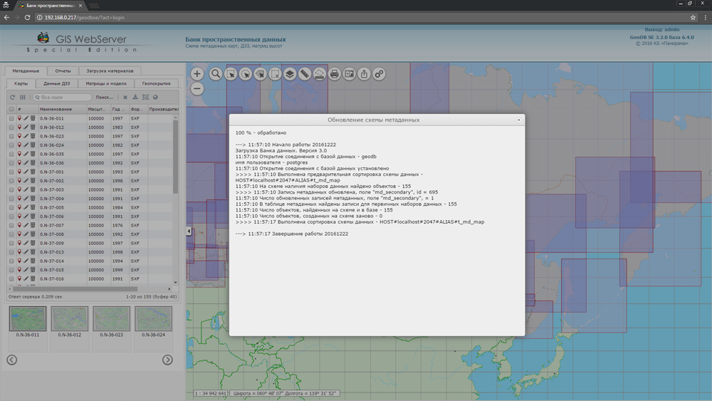
In KB "Panorama" the of version 3.3 is developed. In the new version a speed of placing the data into storehouse is increased at the expense of performing the loading process into multiple threads. The greatest gain in speed is achieved by placing into the repository a large number of files. Interface of customizing the access rights to metadata schemes is updated, possibility of a choosing a place of placements of domain groups and users is added.
Databank of digital maps and remote sensing data is intended for gathering, storage, search, issuance of spatial data in exchange formats and displaying the status of a databank in the form of maps-schemes. Maps-schemes are conducted for each type of stored data: vector maps, remote sensing data, matrixes of heights and terrain models. There is provided a remote placing the sets of spatial data into file storehouse, a conducting the versions of stored sets, their registration in base of metadata, update of maps-schemes of data presence. The automated gathering and formation of metadata is performed according to the standards of ISO 19115:2003, Geographic information - Metadata and ISO/TS 19139, Geographic information - Metadata - XML schema implementation. The reduced copies of data images are formed, file checksums and completeness of data sets are checked. At removal of data sets from storehouse there is automatically carried out the editing the base of metadata and maps-schemes of materials availability.
The reference to the Databank and data exchange is carried out via the web-interface. The program can work in operating systems with the closed contour where processing of the protected data is carried out. The databank includes applications the and that are certified by Level 2 of absence of undeclared possibilities in system of certifying securities of information of the Ministry of Defence of the Russian Federation. For conducting the base of metadata there are used the DBMS PostgreSQL (OS Astra Linux SE), DBMS Zarya (OS Zarya Data Processing Center).
The module of administration of the Databank of Digital Maps and Remote Sensing Data is included into the Complex. It provides customizing the general parameters of the application's work, a customizing the parameters of metadata database, a choosing the formats of storage and the composition of groups of stored files, views of objects for maps-schemes, a conducting the groups of users and appointment of the users rights onto access to the data and allowed actions. Users of desktop programs of GIS "Panorama", "Panorama-editor" and others can connect to the Bank of metadata via the GIS Server for work.
New versions of software and documentation are available on the page.


In KB "Panorama" the GIS "Panorama" of for x64 platform is developed. In the new version of the program there is added the possibility to open rasters from the GIS Server which were formed from the GeoTIFF format without copying the image into file RSW (the multispectral multichannel rasters displayed through GDAL library).
The program improved display of rasters with cutting the images by a frame for various scales. This allows you to more accurately display the mosaic of rasters without discrepancies and overlaps of adjacent raster image when zooming. New implementation of forming the images of the raster's reduced copies allows to improve details of the survey image.
Converter from SHP format is improved. The converter adds support for file names, field names and attribute values in the national encoding. There is added an automatic identification of the set name and the classifier object (by key or name). Possibility is implemented for creation of the new classifier with the subsequent primary automatic classification of objects and characteristics. Tools are added for customizing the protocol's content of the initial data composition.
There is improved the task "Assemblage of symbolical semantics" intended for forming the character string as the value of the semantics and assignment of this value to the marked objects. To the list of the original semantics of objects there is added the list of keywords for recording into semantics of metadata of object or of a map (the date of the terrain state, the nomenclature of the map sheet, GUID of a map sheet, object name, layer name, security classification and others).
In the task "Map Computer" there is modified the mode "Information about the object". The mode allows you to collect the data about the terrain object consisting of a great number of separate parts, by the object identifier (the road number, the river name and so forth). Into dialog the options are added that allow you to collect the object from parts of different layers. It allows to receive more complete information about the object in general and the distribution of properties (semantics) by individual parts.
In the dialog box "Select object" there is changed the algorithm for calculating the area of the objects having extent on a longitude more than 5 degrees. Extended objects are cut by strips in UTM projection, no more than 5 degrees on a longitude. The total area of objects is calculated by conventional zones and summed. The extended accuracy of calculation of the area is provided at a selecting the "Clarify the area and length" in the menu "Options" and a choice in Select Object dialog in the pop-up menu for item "Accuracy of coordinates display" of the value "Extended".
In dialog "Search by address" to specify the name of the desired street there is expanded the list of types of semantics. Possibility is added for search of streets by semantics with type "Code from the classifier (directory)". The choice of the name of street is executed from in advance prepared list in the classifier.
In the module "Geodesy calculations" a processing of orientation angles is improved. Position of any object on the ground is specified in a format of orientation angles between the initial (specified) direction and a direction onto object and distance to the object. Orientated angles of directions are: rotary angle, direction angle and rhumb.
The new version of the program is available for downloading in the section.


Ph.: +7 (495) 739-0245, +7 (925) 221-1603
www.gisinfo.ru | panorama@gisinfo.ru
105005, Russia, Moscow, Baumanskaya Street 7, building 1, office 229 (m. Baumanskaya)
Copyright © Panorama Group 1991 - 2024


 Mobile version
 Full version