Copyright © Panorama Group 1991 - 2024

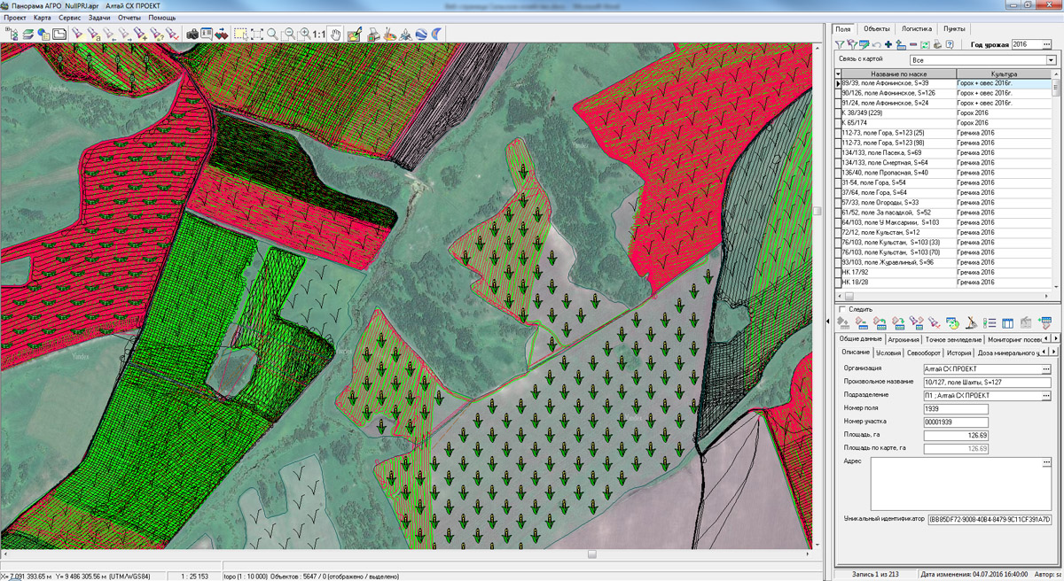
In KB "Panorama"the version 4.9 is developed. The new version provides detailed mapping the executed field works. Onto a map in the form of polygon objects there are plotted the exact contours of worked areas and related information: turnaround time, agricultural operations, performer, data on fertilizer, ameliorations, plant protection products and other information. Initial information for monitoring the progress of field work and drawing up the relevant detailed cartograms of their implementation are the navigation data coming from the satellite positioning system equipment installed on agricultural machinery and motor vehicles.
Navigation information from the operators of satellite positioning systems (Wialon, AutoGraph, GLOSAV and others) comes automatically for further processing in GIS. The received data include the data about spatial position of monitoring's object, time of measurements registration, indications of various sensors (fuel consumption, loading, work of the unit and others). Using the collected information, indicators of carried out works automatically are calculated: the worked area, the traveled distance, fuel consumption, volume of the brought fertilizers. The built-in system of technological planning and the plan-fact analysis allows to correlate actually performed works with the planned agro-technical actions.
Agrarian GIS "Panorama" is is based on the software products: "Panorama AGRO", , , "Workstation of Agronomist", Panorama AGRO Service and GIS WebServer AGRO SE. Various combinations of these products in conjunction with the cartographical server () and professional allow to create a single geoinformation space of agricultural holding.
The use of remote sensing data, the results of satellite navigation measurements, readings of different sensors and building on their basis of corporate agrarian geographic information system has proved highly effective in the management of agro-technical activities and ensuring reliable control technologies of cultivation of agricultural crops.
New versions of software are available for download in the section.


In KB "Panorama" the version 11 is developed. In the new version for the purpose of increase in productivity of service there are refined the architecture and a principle of functioning of PHP module of the application. New configuration files are added, allowing to reduce time for request processing. New features allow you to increase the upload speed of tile data in a 3-fold up to 4 milliseconds and to reduce the processing time for WMS, WFS, WCS and other RESTAPI and XMLRPC requests up to 30-40 ms.
For carrying out the check of throughput and speed of data return there was used the computer with operating system Centos 6.7 (4-core Intel Core i5 processor, 16 GB of RAM), ngnix, php-fpm. During all tests the computer's workload was 100 %. Testing was made on the standard map which is a part of installation, the map of the city of Noginsk consisting of 5000 objects. Tests have been carried out: "The return of finished tiles", "Performing the WMS requests" and "Giving back of tiles with the drawing, compressed and stored on the server disk."
The interface of the service's administrator is improved. Possibility of choosing a geoportal from the list of data is added. There is added a request for the Data Bank - downloading files from the GIS Server. The request of synchronization of setup files of the service is implemented. The request of obtaining the semantic characteristics of a map in GeoJSON format is improved.
GIS WebService SE supports all international standards (OGC WFS, WFS-T, WMS, WMTS, WCS), by means of which the transmission and display of spatial data are carried out. The application has the possibility of issuing tiles for any user or local coordinate system. The application is implemented on Windows and Linux platforms, is compatible with web-server the Apache, IIS, nginx.
The new version of the program and the documentation are available on the web-site in section.


Geoportal updated the maps of Kaluga and Kostroma regions formed according to OpenStreetMap data. Source data obtained from the website are complemented by objects from maps of scale 1: 1 000 000. There are added the objects of hydrography, vegetation, road network. For work with the received map it is possible to use the program of GIS Panorama Mini or other software products of KB "Panorama".
Publishing of updates in bank of spatial data is made by using the program of Complex of conducting a databank of digital maps and remote sensing data. Publishing contents of bank of spatial data on the geoportal and data access for downloading are implemented by means of .
Free maps on the basis of OpenStreetMap data are available for download on the page "Digital maps and images".

In KB Panorama the version 2.4 is developed. In the new version the mode of creation of geo-coverings from stored data sets is implemented. The mode allows the operator of the Databank to select data sets by various criteria (territory, date of terrain shooting, scale, type of a material and others) and to form coverings from vector maps, rasters or matrixes in the chosen coordinate system. Procedure of forming a geo-covering is carried out on the by the command of the Databank operator.
Coverings are placed in the specified virtual folders of Server GIS that provides automatic access to them without additional administration of various groups of users. For convenience of conducting versions of geo-coverings in the specified virtual folder the separate folders for each covering automatically are created.
Configuring of virtual folders for placing geo-coverings is carried out by the Administrator of Databank of Digital Maps and Remote Sensing Data for each group of the data. Coordinate system of a covering can be specified by EPSG code (for example, "epsg:3857") or by a code of the user's coordinate system (for example, crslist:user_code).
In this case the coordinate system parameters are read on the GIS Server from the service file by the specified code of user's coordinate system (identifier). Parameters of the user's coordinate system can be added onto the GIS Server from the task "Map Passport" of system the .
Upon termination of procedure of forming the geo-covering to the user the work protocol is given. Data sets of geo-coverings are recorded in database of metadata and displayed on a map-scheme. Objects of geo-coverings of different groups of the data have different color filling on the scheme.
The complex of conducting the Databank of digital maps and remote sensing data is intended for gathering, storage, search, issuance of spatial data in exchange formats and displaying the status of a databank in the form of maps-schemes. Maps-schemes are conducted for each type of stored data: vector maps, remote sensing data, matrixes of elevations and terrain models. The reference to the Databank and data exchange is carried out via the web-interface. The program can work in operating systems with the closed contour where processing of the protected data is carried out. The databank includes applications the GIS Server and that are certified by Level 2 of absence of undeclared possibilities in system of certifying securities of information of the Ministry of Defence of the Russian Federation. For conducting the base of metadata there are used the DBMS PostgreSQL (OS Astra Linux SE), DBMS Zarya (OS Zarya Data Processing Center).
Programs of GIS WebService SE and GIS Server provide a remote placing the sets of spatial data into files storehouse, a conducting versions of stored sets, their recording in the base of metadata, the updating of maps-schemes of data presence. The automated gathering and formation of metadata is performed according to the standards of ISO 19115:2003, Geographic information - Metadata and ISO/TS 19139, Geographic information - Metadata - XML schema implementation. Also the reduced copies of data images are formed, file checksums and completeness of data sets are checked. At removal of data sets from storehouse there is automatically carried out the editing the base of metadata and maps-schemes of materials availability.
The module of administration of the Databank of Digital Maps and Remote Sensing Data is included into the Complex. It provides customizing the general parameters of the application's work, a customizing the parameters of metadata database, a choosing the formats of storage and the composition of groups of stored files, views of objects for maps-schemes, a conducting the groups of users and appointment of the users rights onto access to the data and allowed actions. Users of desktop programs of GIS "Panorama11", and others can connect to the Bank of metadata via the GIS Server.
Source codes of modules of loading the sets of spatial data and metadata into the Databank of Digital Maps and Remote Sensing Data are included into SDK for the and . Using SDK it is possible to expand operations on conducting archive of spatial data from other applications. New versions of software and documentation are available on the page.


In KB "Panorama" the of version 11.13.4 with the interface in English is developed. In the new version of the program there are refined the tools of creating and updating maps, tools of work with databases, maps designing by complex conventional signs, calculation tasks, the block of cadastral tasks and other modules.
There is added the possibility to open multisheet maps on top of other multi-sheet maps or previously opened raster, matrix data and geoportals. It accelerates displaying a great number of sets of vector maps and simplifies the administration of vector maps of various purposes through the using several levels of multisheet maps.
In the menu File \ New and File \ Update by list the possibility is added for creation and update of a multisheet map (MAP) or the project of vector maps (MPT) from a set of files SXF, TXF, RSC, SITX which are stored in ZIP-archives. At choosing files of format ZIP in the list of chosen maps the names of files from archive automatically will be added. Unpacking of archives is carried out automatically at import of maps into region of works. It allows to simplify actions of users at a choosing a plurality of data sets from the which are loaded from the server in the form of ZIP-archive.
Into the Map Legend dialog the "Model" bookmark is added intended for displaying and editing parameters of irregular models of a surface - TIN-models (model of terrain) and MTD-models (a cloud of points).
In application the "Database" the new mode is added, allowing to create reports in the OpenOffice format. Unloading into the report is made with using the tools of spreadsheet OpenOffice Calc which is a part of the OpenOffice.org suite.
List of units of measure is expanded at displaying distances and heights. There is added a choice of heights in feet and distances in nautical miles. Into dialog of building a profile of heights there are added the units of length measure - kilometers, nautical miles and the height measurement units - ft.Into dialog "Calculator" there are added the units of measure - inches, ft, yards.
The interface of dialog "Address search" is improved. The current line of the address is displayed in the header of the dialog box. There are added the buttons for fast transition along the list - Next and Back. In header of the dialog window the quantity of the found addresses and number of the current title among them is displayed. At moving under the list of addresses there is performed an automatic transition into a point corresponding to the address.
Into modes of Map Editor - "Create subobject", "Create subobject by copying", "Merge objects" - there is added the possibility of forming the multipolygon - the polygonal object with subobjects outside the object contour. At converting to SXF, TXF and back the multipolygon sign is saved. At calculating the area of multipolygon, the area of external subobjects will be added to the area of the main object, and the area of internal subobjects will be subtracted. Displaying multipolygons with hatching for correct filling of external contours is improved.
Into the bookmark "Metrics" of the dialog "Select object" the toolbar for processing of heights is added: load of values from a matrix, interpolation by spline, change of height of all points onto the specified size.
Into library of a map export into format DXF the new mode "Make line style by object key" is added. Use of this mode is possible only at export of a map in the form of "Scheme" (parameter "Draft type"). At converting there is preserved the object integrity of linear and polygon objects, with creation of lines styles which names correspond to the key of the object. External view of generated styles of lines can be changed further in the environment of work with format DXF. For example, in AutoCAD the "Designing Standard" can be applied or the file of lines styles may be loaded.
Updating the information resource is executed for English-speaking users of . According to new adaptive design there are re-issued the sections "About the firm", "Education", "Price", "Download" and "Products".
On information resources of the company (gisinfo.ru, gisinfo.net) there is always available for download the actual versions of software products - GIS "Panorama", GIS WebServer SE, GIS Server and others. Users can familiarise with the documentation and training materials on work with programs. On the page "Digital maps and images" and on the geoportal "Bank of the spatial data" there are presented free maps in format SXF on the basis of data from open sources. For acquaintance with possibilities of server solutions of KB "Panorama" on the gisserver.ru site there are presented the examples of information geoportals on the basis of GIS WebServer SE (GIS WebServer).
The new version of the program and the documentation are available for download in the .
Ph.: +7 (495) 739-0245, +7 (925) 221-1603
www.gisinfo.ru | panorama@gisinfo.ru
105005, Russia, Moscow, Baumanskaya Street 7, building 1, office 229 (m. Baumanskaya)
Copyright © Panorama Group 1991 - 2024


 Mobile version
 Full version