Copyright © Panorama Group 1991 - 2024

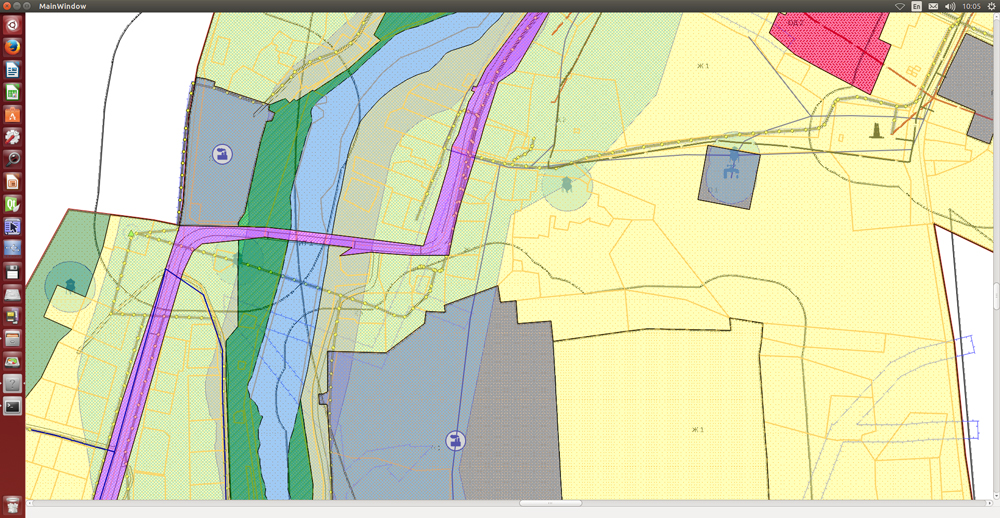
In KB "Panorama" the GIS Constructor version 11.10.3 is developed for operating system Ubuntu 14.04. In the new version the library terrplan.iml is refined for visualization of objects of the digital map classifier terrplan.rsc, providing preparing a graphic part of documents of territorial planning.
In combination with digital classifier the survey.v4.rsc there is ensured a preparation of urban land plans and other documents of urban planning activities. For reducing the list of conventional symbols in the classifier there are used the programmable symbols, which automatically form a symbol image of required view and size with taking into account a set of attributive characteristics of object.
GIS Constructor is a set of components for use in a visual programming environment Qt Designer, which allows to develop GIS applications. Visualization of contents of digital maps is made in the conventional symbols accepted for topographical, geographical, cadastral and other types of maps. Geoinformation system has ample opportunities for creation (addition) of user conventional symbols. Various coordinate systems and projections are supported.
The new version of the program is available for download in the Download section.


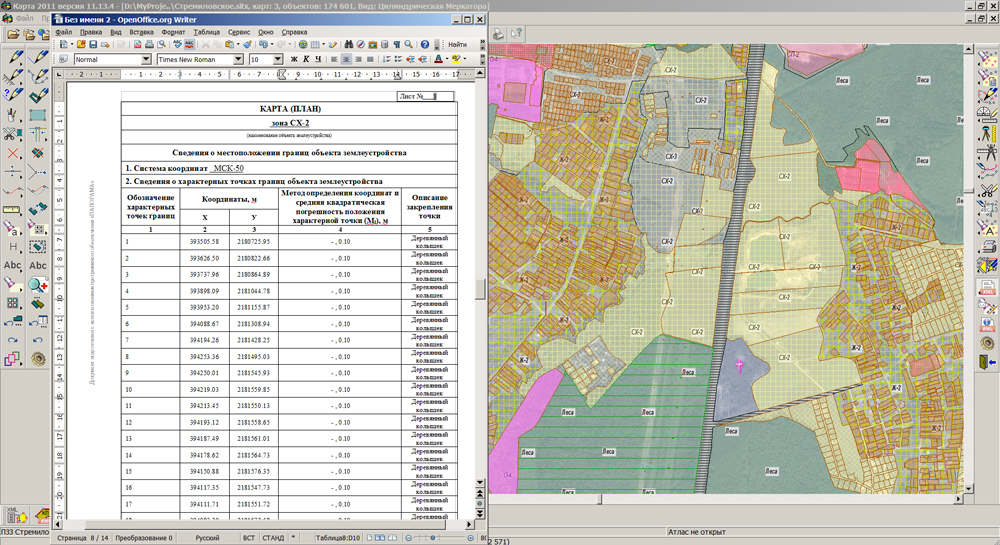
In KB "Panorama" the version 11.13.4.1 is developed. In the new version of the program the mode "Map (plan) of object of land management" is modified in accordance with the changed requirements to its formation, approved by the Governmental Decree of the Russian Federation from May, 17th, 2016 № 444 "On amendments to some acts of the Government of the Russian Federation". The made amendments establish that "Map (plan) of object of land management" is made by results of the location description or an establishment of borders of object of land management or a part (parts) of such borders. In accordance with the changed form of a map (plan) of object of land management the report templates are updated and the procedure of its automated formation is refined. Tools are developed for filling the new section "Information on location of the modified borders of object of land management". For processing the information about a part (parts) of border of object of land management the algorithm of variational fillings of data on characteristic points is implemented. For all border of object of land management there is filled the requisite "2. Information on characteristic points of borders of object of land management", and for a part (parts) of border of object of land management there is filled the requisite "3. Information on characteristic points of a part (parts) of border of object of land management".
In the mode "Information from the State Real Estate Cadastre" there is added the function of request and display of data about objects of capital construction. The mode "the Scheme of an arrangement of plot (plots) on the cadastral plan of territory" is improved, at formation of one plot the "Definition" attribute of NewParcel requisite is not recorded. The mode "Land Survey Plan" is improved, there is added a variational recording the information on the attached files (Appendix) of the Documents requisite for section InputDataс with considering the version of the land survey plan (5 or 6).
The new version of the program is available on the web-site in the .
Geoportal updated the maps of Vladimir and Voronezh regions formed according to OpenStreetMap data. Source data obtained from the website are complemented by objects from maps of scale 1: 1 000 000. There are added the objects of hydrography, vegetation, road network. For work with the received map it is possible to use the program of or other software products of KB "Panorama".
Publishing of updates in bank of spatial data is made by using the program of . Publishing contents of bank of spatial data on the geoportal and data access for downloading are implemented by means of .
Free maps on the basis of OpenStreetMap data are available for download on the page "Digital maps and images".

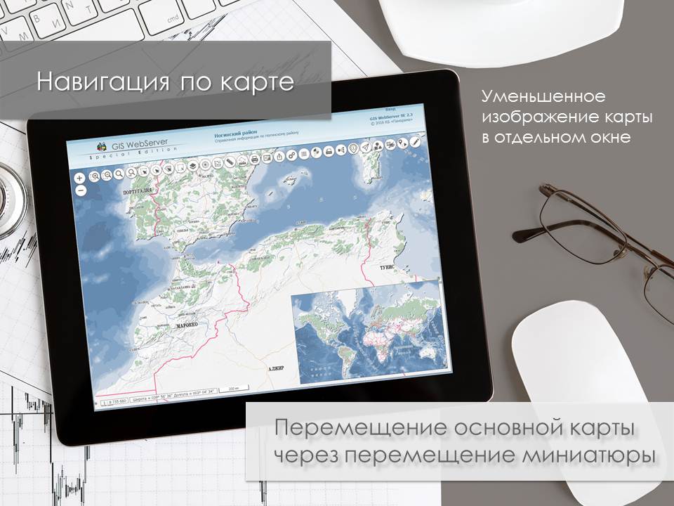
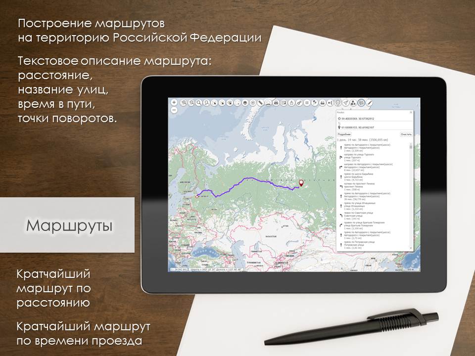
Specialists of KB "Panorama" updated the on using for creation of information geoportals. GIS WebServer SE provides remote access to the spatial data, their publication in the form of a graphic map image. The program has interactive possibilities for obtaining the information about map objects, a map editing and execution of special calculations on a map.
GIS WebServer SE together with server applications the , GIS WebToolKit SE, are included into software complex the . The program complex is intended for conducting bank of spatial data, for publication of digital cartographical information, data of remote sensing of the Earth (RSE), the organizations of remote interaction with the automated control systems, systems of monitoring the terrain status and others.
GIS WebServer SE includes service the GIS WebService SE which contains means of access to the spatial data bank, implements the complicated algorithms of information processing, has the integrated means of ensuring safety. Data exchange with service is performed according to standard OGC protocols and REST API interface. GIS WebServer SE is implemented with using the tools of GIS WebToolKit SE, which can be used in the development tools that use the JavaScript.
Presentation materials on GIS WebServer SE are available on the page. You can read the documentation for the software product in the "Documentation" section.


Geoportal updated the maps of Belgorod and Bryansk regions formed according to OpenStreetMap data. Source data obtained from the website are complemented by objects from maps of scale 1: 1 000 000. There are added the objects of hydrography, vegetation, road network. For work with the received map it is possible to use the program of GIS Panorama Mini or other software products of KB "Panorama".
Publishing of updates in bank of spatial data is made by using the program of . Publishing contents of bank of spatial data on the geoportal and data access for downloading are implemented by means of .
Free maps on the basis of OpenStreetMap data are available for download on the page "Digital maps and images".
Ph.: +7 (495) 739-0245, +7 (925) 221-1603
www.gisinfo.ru | panorama@gisinfo.ru
105005, Russia, Moscow, Baumanskaya Street 7, building 1, office 229 (m. Baumanskaya)
Copyright © Panorama Group 1991 - 2024


 Mobile version
 Full version