Copyright © Panorama Group 1991 - 2024

In KB "Panorama" the x64 version 12 is developed. The program contains a complete set of tools for creating and editing vector maps, import, export and transformation of raster and vector data, means of checking a quality of a vector map and absolute elevations. The new version removes restrictions of 32-bit version onto the memory usage, a more efficient model of work with the available RAM is implemented. It allows to accelerate work with maps of large volume in tasks of displaying a map, search and selection of map objects by conditions of selection chosen by the user, in tasks of editing the big arrays of marked objects, in tasks of building graph of a network and performance of search tasks by the graph.
In the program there is added the mode of special preparation of maps - Pretile preparation of OpenStreetMap data. It is used for creating maps of titles according to OpenStreetMap data before their publication by Web. The task carries out automatic drawing of titles by linear, polygon, point and vector objects, with the exception of possibility of mutual crossing the titles. Thus, several maps of titles are created - onto each scale of a set chosen by the user. Ready maps of titles are displayed over the original vector map. At the same time the visibility of each map of titles is limited by its range. This approach maximizes the readability of the maps published by means of GIS WebService SE. The input data for the task is the multisheet map created from SXF-files loaded by means of the Program of stream loading the OpenStreetMap data. The output data of the task is the set of maps of titles for the scales chosen by the user. Call of task is performed through the menu Tools\ Run Application \ Processing \ Pretile preparation of OpenStreetMap data.
In the task the Creation of works region (menu File \ New) the possibility is added for creation of a multisheet map (MAP) or the project of vector maps (MPT) from a set of files SXF, TXF, RSC, SITX which are stored in ZIP-archives. At choosing files of format ZIP in the list of chosen maps the names of files from archive automatically will be added. Unpacking of archives is carried out automatically at import of maps into region of works. It allows to simplify actions of users at a choosing a plurality of data sets from the Databank of digital maps and remote sensing data which are loaded from the server in the form of ZIP-archive.
The program allows you to open multisheet maps on top of other multi-sheet maps or previously opened raster, matrix data and geoportals. It accelerates displaying a great number of sets of vector maps and simplifies the administration of vector maps of various purposes through the using several levels of multisheet maps.
Panorama-Editor allows you to perform conversion of vector and raster data, on the fly combines the maps of any projections with the selected geoportal. It allows to carry out operatively a binding the own maps to the terrain, to edit the combined maps and to form report documents. Formation of report documents is carried out in the Reports Editor, which contains tools for preparation and a print of complex reports including maps, graphics, multi-line text with different attributes, embedded Office documents and tables, out-of-frame designing, coordinate grids and other elements. Call of the task is performed through the menu File\Print Report. The new version of the program is available for download in the Download section.


Geoportal updated the maps of Perm Krai and the Chuvash Republic formed according to OpenStreetMap data. Source data obtained from the website are complemented by objects from maps of scale 1: 1 000 000. There are added the objects of hydrography, vegetation, road network. For work with the received map it is possible to use the program of GIS Panorama Mini or other software products of KB "Panorama".
Publishing of updates in bank of spatial data is made by using the program of Complex of conducting a databank of digital maps and remote sensing data. Publishing contents of bank of spatial data on the geoportal and data access for downloading are implemented by means of .
Free maps on the basis of OpenStreetMap data are available for download on the page "Digital maps and images".

On the web-site of KB "Panorama" there are published the source codes of development tools for creation and connection of dynamic libraries of processing of REST-queries to the GIS WebService SE for Astra Linux SE operating system. Software Development Kit (SDK) allows developers to create new applied queries and to process them by means of functions in C++ language of MAPAPI interface from the GIS-kernel. It facilitates a writing of service modules for programmers having experience of operation with GIS Constructor products.
Composition of SDK includes libraries in C++ language with examples of processing REST-queries. Formation of queries and displaying the results of their processing takes place in the client-side of web-based applications with using the library of components the GIS WebToolKit SE. Components of GIS WebToolKit SE are written on JavaScript for reduction of the development time of web-applications that use the geospatial data. At addition of new queries and libraries into GIS WebService SE it is expedient to add and new components into GIS WebToolKit SE for application of new queries and their embedding into a server code on PHP or other languages of development. Thus, the developer has full control over the implementation of web-applications.
GIS WebService SE provides the high-speed transport protocol of data transmission from the client to server libraries and can be run on various platforms (Windows, MSVS 5, АstraLinux SE, Zarya, RedHat, Solaris, QNX and others), supports the various types of processors (Intel, ARM, Elbrus) and various types of web-servers (ngnix, Apache, IIS). GIS WebService SE is certified in the system of certification of information protection requirements for information security, is compatible with certified data protection and supports Kerberos and Active Directory domain authentication.
GIS WebServiсe SE uses the basic international standards (OGC WFS, WFS-T, WMS, WMTS, WCS) with which help the transfer and display of spatial data is carried out. The application has the possibility of issuing tiles in the user or local coordinate system. Connection to the GIS WebService SE embedded library is carried out on the basis of five standard functions. All setup files of the program are stored in folders of shared access to the data. For enhancement of possibilities of processing arbitrary queries the mechanism of issuing files of large size is added. File size can be up to several terabytes and is limited only by your hard drive capacity.
There is added a high-speed search of objects by semantic characteristics of the layers published in service. Queries are added: downloading of published files of large size from service, calculation of the optimal route by the graph of road, building a thermal map in the form of a matrix of qualities, construction of a map legend by the classifier, the scheme or the layer, loading a raster image in a format bmp, jpg, png on the server into a new layer. Issuance of results is standardized by the format of GML ISO 19109:2005, ISO 19115:2003. External , bases of geodata implemented by standard OGC 06-103r4, or other web-services can be a source of data for performance of applied queries. Connection to the specified sources is provided by MAPAPI-interface functions.
The source codes are available for download in the Download section.

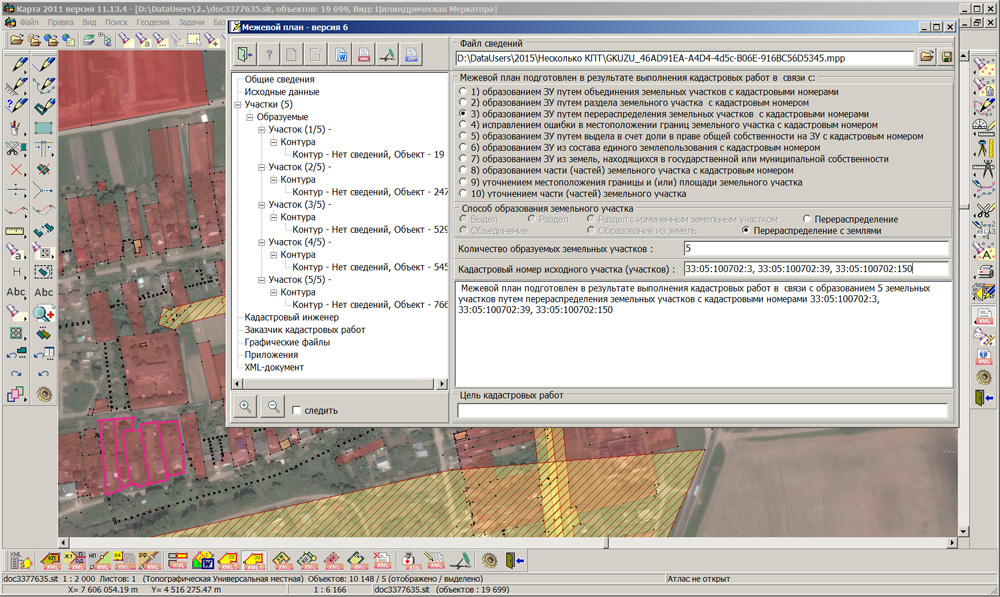
In KB "Panorama" the version 11.13.3 is developed. The new version carries out formation of the XML-document - the land-survey plan of the land plot in the form of electronic document under XML-scheme MP_v06. The new version of XML-scheme is introduced by the order of Rosreest of April, 6th, 2016 № P/0159 "On Amendments to the annex to the order of Federal Service for State Registration, Cadastre and Cartography of 7/10/2015 № P/367 "About the organisation of works for the provision into body of the cadastral registration of documents in the form of the land-survey plan of the land plot in the form of an electronic document".
The current version of the dialog "Land Survey plan" provides formation of the land-survey plan in the form of an electronic document under XML-schemes MP_v05 and MP_v06. In dialog there is implemented a variational saving in the XML-document of information about the address of the land plot and the address of the cadastral works' customer - for version 5 with Note element, and for version 6 without Note element and with additional attribute AddressOrLocation. When you save into XML-document the information on the attached file (Document element) for the version 5 the AppliedFilePDF element is recorded, and for Version 6 - the AppliedFile element. For XML-file of version 6 in the information about the method of land formation the "Redistribution with the lands" variant is added. Dialog "Editing of REGISTRATION DATA of object (semantics) of cadastral works" is improved. There is implemented the variational entering the information about a type of permitted land use in the preparation of information for the surveying plan of version 6. The user can specify a type of permitted use by the outdated classifier and by the document or by the new classifier approved by the order of Ministry of Economic Development of Russian Federation of 9/1/2014 № 540.
The new version of the program is available for download in the Download section.


Geoportal updated the maps of Moscow and the Moscow Region formed according to OpenStreetMap data. Source data obtained from the website are complemented by objects from maps of scale 1: 1 000 000. There are added the objects of hydrography, vegetation, road network. For work with the received map it is possible to use the program of GIS Panorama Mini or other software products of KB "Panorama".
Publishing of updates in bank of spatial data is made by using the program of Complex of conducting a databank of digital maps and remote sensing data. Publishing contents of bank of spatial data on the geoportal and data access for downloading are implemented by means of .
Free maps on the basis of OpenStreetMap data are available for download on the page "Digital maps and images".
Ph.: +7 (495) 739-0245, +7 (925) 221-1603
www.gisinfo.ru | panorama@gisinfo.ru
105005, Russia, Moscow, Baumanskaya Street 7, building 1, office 229 (m. Baumanskaya)
Copyright © Panorama Group 1991 - 2024


 Mobile version
 Full version