Copyright © Panorama Group 1991 - 2024

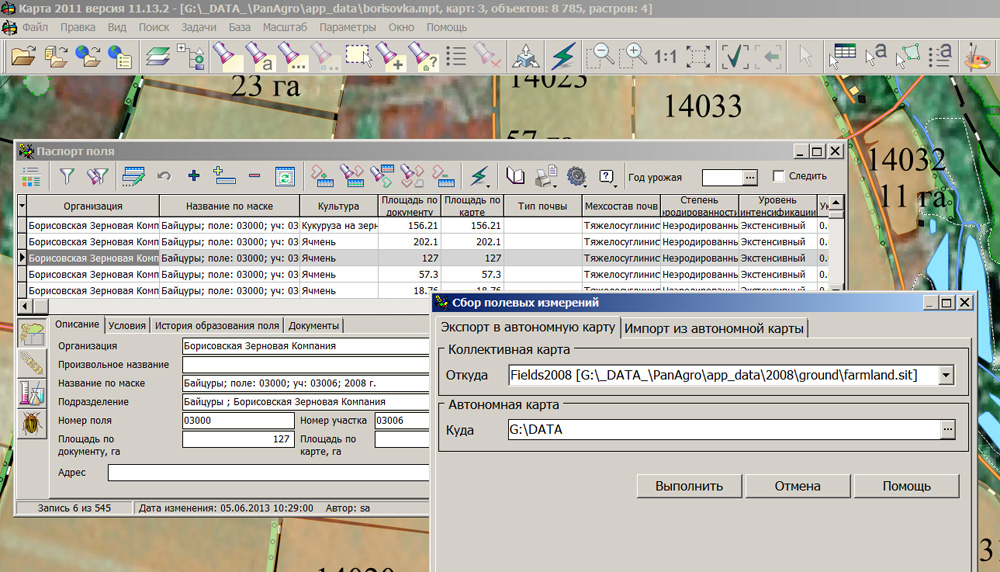
In KB "Panorama" the "Workstation of agronomist" version 11.13.3 is developed. In the new version the "Complex of agronomical tasks" is supplemented by tools of loading the map layers from a collective database and the subsequent synchronization of information about contours of agricultural land obtained in the conditions of autonomous work. At carrying out field works the agronomist can take with himself the mobile device (tablet) on which there is installed the software "Workstation of agronomist" with a set of maps for autonomous use.
For stand-alone maps all tools of processing and the analysis of spatial data are supported. On these maps it is possible to specify immediately borders of farmland contours, to put new working areas, and also to put attributive data into semantics of map objects. According to monitoring results, any information (composition of soil, agrochemical parameters, presence and number of pests, external factors of natural character, the course of the sowing or harvesting and other information) will be entered into the electronic field book in the form of autonomous agronomist map. The program supports technology of gathering and carrying over the results of field inspections onto the collective map of the enterprise hosted on the , with the subsequent updating a database of fields history. There is supported the unloading and subsequent synchronization of a collective database by the information from autonomous maps of several specialists.
During the import procedure there is formed the report of comparison of autonomous map and collective map which contains the report on all made operations with accounting objects. The agriculturist independently makes the decision on inclusion of any operation into process of data synchronization. The program interface is adapted to the use of various font settings of your computer screen.
The new version of the program and the documentation are available on the web-site in section.


Representatives of KB "Panorama" took part in work of the . The event was held from 2 to 5 June 2016 in Astana on the territory of Air Base of Armed Forces of Republic of Kazakhstan. During the exhibition there were held scientific seminars on the theme "Problems and prospects of development of armaments, military and special equipment of the army of the XXI century".
During the seminars the chief technologist of KB "Panorama" Alekseev Sergey had presented the report, which aroused great interest among the participants. Such software solutions as the , , were considered. During the exhibition there were a series of business meetings of specialists of KB "Panorama" with representatives of Kazakhstan, Belarus and Russian companies, scientific and educational institutions. Work of the company's specialists at a forum was highly appreciated by its organizers. By the results of the forum, KB "Panorama" was awarded by a diploma and a medal.
The forum was organized by the Ministry of Defense of the Republic of Kazakhstan, NC "Kazakhstan Engineering", "Kazspetsexport". "Kazakhstan GIS Center "- the partner of KB"Panorama" in the Kazakhstan market of geoinformation technology was the technical sponsor of an exhibition. The exhibition was attended by over 350 companies from 44 countries. The exhibition was visited by the President of Kazakhstan, as well as the Ministers of Defence of Kazakhstan and the Republic of Belarus.


In KB "Panorama" the version 6.3.3 is developed for Astra Linux SE operating system. The new version fully implemented the technology of pass-through trusted authentication Kerberos. Kerberos is a protocol that provides centralized users authentication and uses technical data masking to counter different kinds of attacks. With the help of "GIS Administrator" program, you can configure user authentication by Kerberos means. GIS Server x64 SE is intended for providing remote access to cartographical data of users of the , and other applications developed in the environment of GIS Constructor of version 11 and later. The connection to the server is established via TCP/IP protocol.
Data posted on the GIS Server are protected from unauthorized reading, editing, copying, printing and substitution. Possibility of encoding the transferred data is supported. This prevents data interception and substitution at the time of transmission by open communication channels. Data are encoded by 256-bit key, installed onto a particular session. Encoding is performed when reading and writing data. GIS Server x64 SE is certified by Level 2 of undeclared capabilities absence of the system of certification of means of information protection of the Ministry of Defense of the Russian Federation.
The new version of the program is always available for download in the section.

In KB "Panorama" the Converter of large-scale plans into format DXF of version 8.3 is developed. In the new version of the program there are updated the RSC classifiers for large-scale charts and plans of scales 1: 500, 1: 1 000, 1: 2 000, 1: 5 000. There are refined the modes of scaling the DXF classifier objects and function of saving settings files of the program interface.
Converter allows you to form a large-scale topographic map or a plan in DXF format in the standard conventional symbols adopted for performance of cartographical works in the Russian Federation. Previously there is carried out a creation, quality control and designing a map in SXF format by use of RSC classifiers. Prepared maps are converted into format DXF with observance of uniform requirements on designing of conventional symbols of maps and plans. Delivery set includes classifiers and libraries of conventional symbols of DXF format for large-scale maps and plans of scales 1: 500, 1:1 000, 1: 2 000, 1: 5 000.
The new version of the program is available for download on the page.


Geoportal updated the maps of Republic of Tatarstan and the Ulyanovsk region formed according to OpenStreetMap data. Source data obtained from the website are complemented by objects from maps of scale 1: 1 000 000. There are added the objects of hydrography, vegetation, road network. For work with the received map it is possible to use the program of or other software products of KB "Panorama".
Publishing of updates in bank of spatial data is made by using the program of Complex of conducting a databank of digital maps and remote sensing data. Publishing contents of bank of spatial data on the geoportal and data access for downloading are implemented by means of .
Free maps on the basis of OpenStreetMap data are available for download on the page "Digital maps and images".
Ph.: +7 (495) 739-0245, +7 (925) 221-1603
www.gisinfo.ru | panorama@gisinfo.ru
105005, Russia, Moscow, Baumanskaya Street 7, building 1, office 229 (m. Baumanskaya)
Copyright © Panorama Group 1991 - 2024


 Mobile version
 Full version