Copyright © Panorama Group 1991 - 2024

In KB "Panorama" the of version 11.13.3 is developed. In the new version the possibilities of software "Forecasting consequences of emergency situations" are expanded. There is added an automated forecast of potential consequences at occurrence of emergency situations on explosive object. It is based on an algorithm that aims to find the overpressure at the shock wave front and the estimate of damage caused by them, and also the nature of the impact of air shock waves on humans. The task allows you to perform calculation of parameters of damaging factors and to construct a zone of possible damage in result of emergency situation. The damage area is drawn onto situation map of emergency situation's area by symbols that match the requirements of the Ministry of Emergency Situations. The new version of the complex contains the expanded list of calculation parameters of damaging factors at occurrence of emergency situations on radiation hazardous object, chemically dangerous object and a hydraulic engineering construction. This allows you more accurately to assess the consequences and the necessary steps to eliminate them.
Possibility is added for creation of a multisheet map (MAP) or the project of vector maps (MPT) from a set of files SXF, TXF, RSC, SITX which are stored in zip-archives. At choosing files of format ZIP in the list of chosen maps the names of files from archive automatically will be added. Unpacking of archives is carried out automatically at import of maps into region of works. It allows to simplify actions of users at a choosing a plurality of data sets from the Databank of digital maps and remote sensing data which are loaded from the server in the form of zip-archive.
The military-oriented GIS "Operator" is adopted to supply the Armed Forces of the Russian Federation by the order of the Minister of Defence of the Russian Federation and is certified in the system of certification of information security for the information security requirements.
The new version of the program is available for downloading in section.


In KB "Panorama" the of version 2.1 is developed. In the new version the mode "3D View" is implemented which serves for displaying spatial data in the form of three-dimensional terrain model on the basis of Web3D technology. The mode allows you in real time to build and to display into browser the three-dimensional model of the Earth's surface onto any terrain ensured by spatial data. There are provided movement throughout the territory of the Earth, the model's scaling, turn and tilt, choice of data sources. Moving and scaling the two-dimensional and three-dimensional views are completely synchronised. Possibility is added for building routes of travel between two points of the terrain on a map of roads graph.
Access to the data (photos, maps and information on the terrain) is provided by Web-services according to the standard protocols OGC and the ISO standards. Service of GIS WebService SE (OGC WMS/WMTS) provides spatial information in the form of graphic images - tiles. As digital model of a relief various kinds of high-altitude data are used: matrixes (in formats SRTM, GeoTIFF, IMG, MTW), TIN-models, cloud of points and others. At request there is carried out an automatic sampling the most exact data onto the specified portion of the terrain with the preset resolution. For transferring the data of digital model of a relief in Web the WCS protocol is used. The data are also contained in the form of tiles and are cached.
GIS WebServer SE can be used at construction of private corporate systems for ensuring protection of data having a security classification or a trade secret. GIS WebServer SE is certified by 2-nd level of undeclared capabilities absence. The new version of the program expands the application's possibilities in solving problems of analysis, management and long-term planning of territories development. GIS WebServer SE is implemented with use of toolkit the GIS WebToolKit SE which can be applied in the development tools that use the JavaScript.
The new version of the program and the documentation are available on the web-site in section.


Geoportal updated the maps of the Republics of Bashkortostan and Mari El formed according to OpenStreetMap data. Source data obtained from the website are complemented by objects from maps of scale 1: 1 000 000. There are added the objects of hydrography, vegetation, road network. For work with the received map it is possible to use the program of or other software products of KB "Panorama".
Publishing of updates in bank of spatial data is made by using the program of Complex of conducting a databank of digital maps and remote sensing data. Publishing contents of bank of spatial data on the geoportal and data access for downloading are implemented by means of .
Free maps on the basis of OpenStreetMap data are available for download on the page "Digital maps and images".

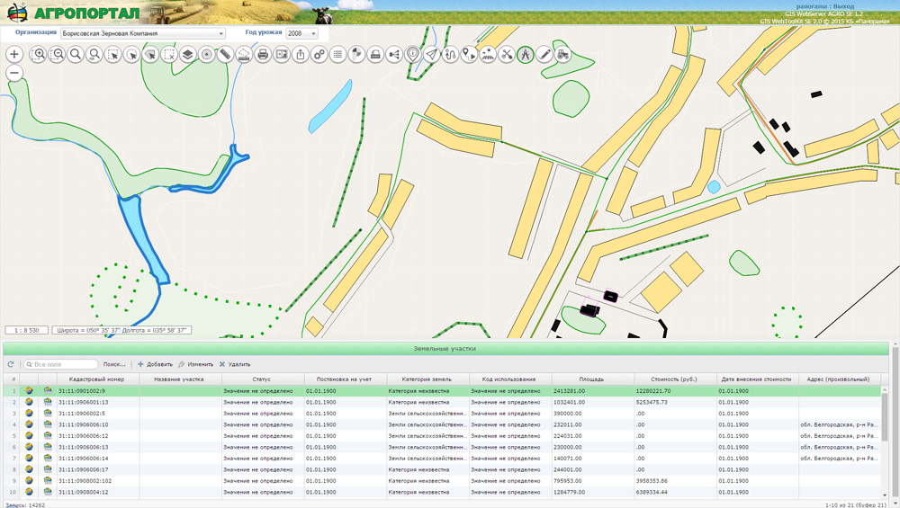
In KB "Panorama" the GIS WebServer AGRO SE version 1.2 is developed. The new version adds the ability to determine the location of users with use of a standard browser. Determining a location or geo-positioning in browser is provided by various methods. The most exact data about a location are given by navigation satellite system embeded into mobile devices (GLONASS and GPS). LBS technologies (Location-based service) allows you to determine the location of the device: by Wi-Fi access points or by a cell of a cellular network in radius of which the given device is located.
This method of determining the user's location is legal and safe. At transfer the norms of confidentiality are observed, and no information violating a privacy of the user, in determining the places on the map is transferred to the third parties. Resource requests permission for location determination. When the user agrees, his location is determined automatically.
The task of monitoring the agricultural equipment and vehicles is improved. In a mode of viewing the history of moving there are implemented two variants of data analysis: "scrolling" the history of moving and creation of a map of tracks. In the first case it is possible to analyze technics movement in animation mode, and in the second to study at once all tracks for all period of time specified by the user. The program receives information about history of movement from a database of .
New version of GIS WebServer AGRO SE is adapted with service the GIS WebServiсe SE. The maps placed on the can be a source of data for cartographical service the GIS WebService SE. It allows to synchronize work of desktop GIS "Panorama AGRO", web application and mobile clients. Using a single database of agricultural data, including information about the land bank, the structure of sown areas, enterprise infrastructure, the range of agricultural production, the park of technics and related equipment allows to use the web-technologies for the control and management of the enterprise in agriculture from any point of the world. You can familiarise with the example of work of the GIS WebServer AGRO SE on page of the demonstration project.
The new version of the program is available on the web-site in section.


Geoportal updated the maps of Mordovia and Udmurtia republics formed according to OpenStreetMap data. Source data obtained from the website are complemented by objects from maps of scale 1: 1 000 000. There are added the objects of hydrography, vegetation, road network. For work with the received map it is possible to use the program of or other software products of KB "Panorama".
Publishing of updates in bank of spatial data is made by using the program of Complex of conducting a databank of digital maps and remote sensing data. Publishing contents of bank of spatial data on the geoportal and data access for downloading are implemented by means of .
Free maps on the basis of OpenStreetMap data are available for download on the page "Digital maps and images".
Ph.: +7 (495) 739-0245, +7 (925) 221-1603
www.gisinfo.ru | panorama@gisinfo.ru
105005, Russia, Moscow, Baumanskaya Street 7, building 1, office 229 (m. Baumanskaya)
Copyright © Panorama Group 1991 - 2024


 Mobile version
 Full version