Copyright © Panorama Group 1991 - 2024

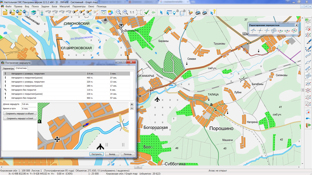
In KB "Panorama" the x64 and x64 of version 12.1.2 are developed. New versions are optimized in terms of volume of used random-access memory at opening of vector maps and remote sensing data of a large volume. Work of programs was tested on maps of OpenStreetMap containing tens of millions of objects in volume more than 10 GB. At construction of the detailed graph of roads by OpenStreetMap maps onto territory of Russia there are formed about 10 million arcs and nodes which together with attributes cannot be processed on the x32 platform. Use of all available RAM allows to accelerate work with maps of a large volume in tasks of displaying the spatial data, search and selection of map objects by the user-selected criteria of selection, at editing large amounts of the selected objects, at construction of the network graph and performance of calculations by the graph.
Applications can effectively work with databases of unlimited volume, and also with rasters of large volumes and data of geoportals which can be displayed together with a vector map. The sizes of programs installations are reduced.
New versions of programs are available in the section.


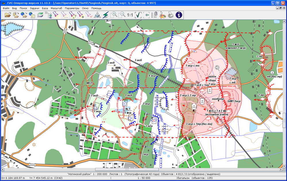
In KB "Panorama" the version 11.13.3 for Astra Linux SE operating system is developed. In the new version the classifier and library of conventional symbols of the operational situation are modified.
There are expanded the composition of objects and service characteristics for a complete and unambiguous description and coding of situation in the form of special maps, including tactical level. Dialog "Creation of object of a map" is improved, objects of the classifier can be represented in the form of a table, a list or a tree of symbols.
The military-oriented GIS "Operator" is adopted to supply the Armed Forces of the Russian Federation by the order of the Minister of Defence of the Russian Federation and is certified in the system of certification of information security for the information security requirements.
The new version of the program is available for downloading in section.


In KB the Panorama the Databank of digital maps and remote sensing data version 2.1 is developed. In the new version there is implemented the selecting and obtaining multitude of data sets to the specified territory in one request, functions of loading data sets into storehouse are automated, customization of displayed characteristics from tables of metadata.
Various types of search and sorting allow to receive the selected sets of spatial data in the form of a single zip-archive in one request. Selection of data may be performed by a spatial filter on a map and by characteristics of metadata.
At placement of spatial data into storehouse the user has possibility to specify the group of data defining a place of storage, or to use the automatic definition. It allows to group the data sets, taking into account their various properties. Data sets of the same format can be stored in different groups, for example, depending on technology of their creation.
User's interface is updated, a customizing the list of displayed characteristics from tables of metadata is added.
Complex of conducting the Databank of digital maps and remote sensing data is intended for gathering, storage, search, delivery of spatial data in exchange formats and for displaying a state of a databank in the form of maps-schemes. Maps-schemes are conducted for each type of stored data: vector maps, remote sensing data, matrixes of elevations and terrain models. Access to the Databank and data exchange is carried out through the web-interface. The databank includes specialized versions of programs the and GIS WebService SE. For conducting database of metadata the DBMS PostgreSQL is used. The programs the
GIS WebService SE and GIS Server provide a remote placing of spatial data sets into file storehouse, a conducting the versions of stored sets, their accounting in base of metadata, an updating maps-schemes of data availability. The automated gathering and formation of metadata is carried out according to standards of ISO 19115:2003, Geographic information - Metadata and ISO/TS 19139, Geographic information - Metadata - XML schema implementation. Also the reduced copies of data images are formed, the files checksums and completeness of data sets are checked.
The module of administration of the Databank of Digital Maps and remote sensing data is included into composition of the Complex. It provides customizing the general parameters of the application's work, the customizing the parameters of metadata database, a choice of formats of storage and the composition of groups of stored files, types of objects on maps-schemes, a conducting groups of users and assignment of the users rights to access to data and allowed actions.
Users of desktop programs the , and others can connect to Bank of metadata via the GIS Server for work. Composition of SDK for the GIS Server and GIS WebService SE includes the source codes of modules of loading the spatial data sets and metadata into the Databank of Digital Maps and remote sensing data. Using SDK it is possible to expand operations on conducting archive of spatial data from other applications.
The new version of the program, the documentation and presentation are available on the page.


In KB "Panorama" the software product the GIS WebServiсe SE Mini is developed. GIS WebServiсe SE Mini has full functionality of possibilities as well as the service of GIS WebServiсe SE. The service has sole restriction - it publishes no more than 99 layers of the user data. GIS WebServiсe SE Mini complements the range of software products for the small business enterprises - , , Databank of digital maps and remote sensing data Mini, , .
Service is intended for the publication in the Internet environment of various spatial information, including the vector maps, remote sensing data, geospatial databases and others. The application allows you to combine the spatial data of enterprise (agricultural, cadastral, navigation, ecological and others) and the data from public sources, for example, OpenStreetMap. By means of service it is possible to transfer graphic data image, the metadata, coordinate and attributive descriptions of terrain objects, results of performance of analytical and computational problems. There are supported the operations of transaction to create new, update, or delete the existing objects in spatial data sets on the server to issue the spatial data in formats GML and GeoJSON.
This service allows you to publish geo-coverings containing information about the terrain in a format convenient for analysis, modeling and construction of three-dimensional terrain models. GIS WebServiсe SE Mini supports all international standards (OGC WFS, WFS-T, WMS, WMTS, WCS) with which help transfer and display of spatial data is carried out. The application is implemented on Windows and Linux platforms, is compatible with the web-servers of Apache, IIS, nginx. The new version of
the program and the documentation are available on the web-site in the section.


Geoportal updated the maps of Orenburg and Samara regions formed according to OpenStreetMap data. Source data obtained from the website are complemented by objects from maps of scale 1: 1 000 000. There are added the objects of hydrography, vegetation, road network. For work with the received map it is possible to use the program of GIS Panorama Mini or other software products of KB "Panorama".
Publishing of updates in bank of spatial data is made by using the program of Complex of conducting a databank of digital maps and remote sensing data. Publishing contents of bank of spatial data on the geoportal and data access for downloading are implemented by means of GIS WebServer SE.
Free maps on the basis of OpenStreetMap data are available for download on the page "Digital maps and images".
Ph.: +7 (495) 739-0245, +7 (925) 221-1603
www.gisinfo.ru | panorama@gisinfo.ru
105005, Russia, Moscow, Baumanskaya Street 7, building 1, office 229 (m. Baumanskaya)
Copyright © Panorama Group 1991 - 2024


 Mobile version
 Full version