Copyright © Panorama Group 1991 - 2024

In KB "Panorama" the GIS Constructor of version 11.10.1 is developed for operating system MSVS 5.0. In the new version there is expanded the composition of objects and service characteristics for a complete and unambiguous description and coding of situation in the form of special maps, including the tactical level. The classifier and library of conventional symbols of operational situation are modified. Displaying of titles with a contour is accelerated and the font height is refined.
Better placement of titles by a spline is implemented (titles of streets, roads, place names), smoothing of titles contours is improved. White contours of titles can be used to automatically clean the image near the title symbols. This improves the readability of titles on maps with high density of conventional symbols per unit of the area of a map. The range of codes EPSG for CS-42 is expanded. Codes from 28401 to 28460 are processed as CS-42, zones from 1 to 60 accordingly. The new version of the program is available for download in the section.

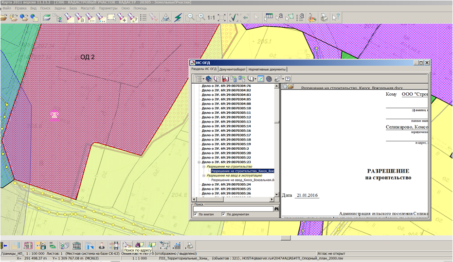
In KB "Panorama" the version 11.13.3 is developed. The new version includes the "Complex of urban-planning tasks" of version 2.6 which provides the systematization and storage of documented information about the development of territories, use and development of land. In the new version there is optimized the placement of a large number of urban-planning documents in a database of information system of ensuring the urban-planning activity with automatic conducting the section "Affairs about built up and subject to development of land plots". There are automated the procedures of forming the documents "Building Permit" and "Permission for commissioning the object" for various objects of accounting by forms approved by the Ministry of Construction and Housing and Communal Services of the Russian Federation of February 19, 2015 N 117/pr. The interface of the new version of the program is adapted for use of various font settings of your computer screen.
For the rapid development by users of application's possibilities the "Workstation of urban-planner" there is prepared a set of demonstration data for conducting the municipal GIS and ISCAS. The model is deployed on the server of KB "Panorama" and provides remote access of users of the desktop program "Workstation of urban-planner" to maps on the GIS Server and data from the database. The demo model of the data allows quickly and clearly to familiarise with possibilities of the "Complex of urban-planning tasks": to study an order of conducting registers of land plots and objects of capital construction; to trace the interrelation between registration units in a database and their link with objects on a map; to fill and use information on regulations of developing the territory of the municipality; to organise accumulation and accounting the documents of urban-planning activity; independently to generate documents such as "Urban Development plan of the land", "Building Permit", "Map (plan) of object of land management" and others. Information about IP-addresses, names of databases, map layers and an operating procedure with the demo data are described in the documentation. The new version of the program is available on the web-site in the section.


Geoportal updated the maps of of Penza and Saratov regions formed according to OpenStreetMap data. Source data obtained from the website are complemented by objects from maps of scale 1: 1 000 000. There are added the objects of hydrography, vegetation, road network. For work with the received map it is possible to use the program of or other software products of KB "Panorama".
Publishing of updates in bank of spatial data is made by using the program of Complex of conducting a databank of digital maps and remote sensing data. Publishing contents of bank of spatial data on the geoportal and data access for downloading are implemented by means of .
Free maps on the basis of OpenStreetMap data are available for download on the page "Digital maps and images".

Representatives of KB "Panorama" have taken part in . The event took place from 18 till 22 April 2016 in Novosibirsk. During work of the exhibition the and of KB "Panorama" were presented to the Governor of the Novosibirsk Region Vladimir Gorodetsky. Work of the company's specialists at the forum was appreciated highly by its organizers. By results of the forum, KB "Panorama" was awarded by diplomas "For the professional representation of their own GIS development","Permanent Partner" of Interexpo GEO-Siberia" and by the honourable prize the "Best project in the field of development and implementation of multi-function GIS".
The forum was organized by the , by the exhibition operator "InterGeoSiberia" with support of the Government of the Novosibirsk region, by the international specialized organisations, the leading companies, universities and research institutions. The Congress was attended by more than 200 organizations from the cities of Russia, CIS and foreign countries. During the Congress there was a series of meetings of specialists of KB "Panorama" with representatives of Russian companies, scientific and educational institutions, as well as colleagues from Germany and the Czech Republic.


Geoportal updated the map of the Kirov region formed according to OpenStreetMap data. Source data obtained from the website are complemented by objects from maps of scale 1: 1 000 000. There are added the objects of hydrography, vegetation, road network. For work with the received map it is possible to use the program of or other software products of KB "Panorama".
Publishing of updates in bank of spatial data is made by using the program of Complex of conducting a databank of digital maps and remote sensing data. Publishing contents of bank of spatial data on the geoportal and data access for downloading are implemented by means of .
Free maps on the basis of OpenStreetMap data are available for download on the page "Digital maps and images".
Ph.: +7 (495) 739-0245, +7 (925) 221-1603
www.gisinfo.ru | panorama@gisinfo.ru
105005, Russia, Moscow, Baumanskaya Street 7, building 1, office 229 (m. Baumanskaya)
Copyright © Panorama Group 1991 - 2024


 Mobile version
 Full version