Copyright © Panorama Group 1991 - 2024

Specialists of KB "Panorama" made updating the classifier for maps of public sources (OpenStreetMap). Into it there are added: a series of objects "Bridges" for each type of roads, polygonal objects into the layer "Infrastructure". The classifier is intended for use with data OpenStreetMap, and also for using the "Technology of import of spatial data from public sources".
On page "Digital maps and images" there are available for download the maps in format SXF, generated on the basis of OpenStreetMap data. For work with these maps you can use . To form and support in an actual state the storehouse of spatial data including digital maps in format SXF, it is possible by means of program Osmloader. and are applied to solve the problems of importing spatial data from OpenStreetMap.
Classifier is available for downloading on pages the "Classifiers" and "Digital maps and images".

In KB "Panorama" the Program of automatic downloading and processing the OpenStreetMap maps of version 6 is developed. In the new version the automatic generalization and analysis of a relative positioning of created titles are applied, procedures for drawing of titles of settlements, polygon hydrography and rail-way stations are added. Classifier osm.rsc (visual characteristics and object composition) is improved. There is updated the list of loading the data from the website gis-lab.info (references onto new subjects of the Russian Federation are added).
Osmloader program is designed to automatically download and process maps from project the "OpenStreetMap data in Shape format". It downloads the data under the user's list by means of the FTP-protocol, unpacks, imports the downloaded maps and carries out their consecutive automatic processing (puts titles of map objects, decodes POI points, makes up crossroads, saves a map copy into format SXF and packs into ZIP format). The program is free under a free license. For work with the received map it is possible to use the program or other products of KB "Panorama". In case of the publication of the spatial data the reference to is obligatory.
The new version of program Osmloader is available for download on the Download page.


By Order of the Ministry of Communications of Russia from 04.08.2016, the is included into the (http://reestr.minsvyaz.ru). Since January, 1st, 2016 in Russia the provisions of legislation on use of the Russian software and a ban on the procurement of the foreign software in the presence of the Russian analogues have come into force. Examination of submitted applications for the inclusion of information about the software products into the register of the Russian software is actualized by the Expert Council under the Russian software.
GIS Server is intended for providing remote access to the cartographical data of users of the , , and other applications developed in the environment of GIS ToolKit of version 11 or later. The connection to the server is established via TCP/IP protocol. Data posted on the GIS Server are protected from unauthorized reading, editing, copying, printing and substitution. Possibility of encoding the transferred data is supported. It prevents interception of data and their substitution at the time of transmission by open communication channels. Data are encoded by 256-bit key, installed for a particular session. Encoding is performed when reading and writing data.
The new version of the program is always available for download in the section.

Geoportal updated the map of the Nizhny Novgorod region formed according to OpenStreetMap data. Source data obtained from the website are complemented by objects from maps of scale 1: 1 000 000. There are added the objects of hydrography, vegetation, road network. For work with the received map it is possible to use the program of or other software products of KB "Panorama".
Publishing of updates in bank of spatial data is made by using the program of Complex of conducting a databank of digital maps and remote sensing data. Publishing contents of bank of spatial data on the geoportal and data access for downloading are implemented by means of .
Free maps on the basis of OpenStreetMap data are available for download on the page "Digital maps and images".

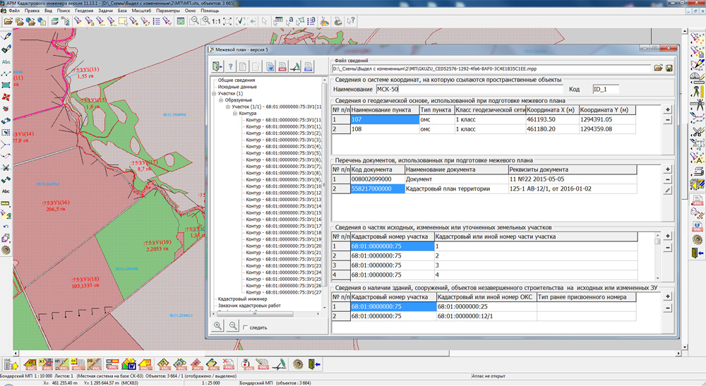
KB "Panorama" developed the updated version of the task "Cadastral documents", a part of of version 11.13.2. There are updated the algorithms of business logic regarding optimisation of the initial data entry procedures.
For preparation of the electronic XML-document and the text report of the land-plan there is used the information from both semantics of map objects, and additionally specified by the user. In the new version of the task "Cadastral documents" for editing the values of semantics a single dialogue "Editing of REGISTRATION DATA of object (semantics)" is used, and for additionally entered data their transfer between various dialogs of data input is automated. Thus, the map with objects of cadastral works can be placed for the multiuser access on . In dialogue "Download cadastral data" there is implemented the possibility of drawing objects from XML-file of the land-plan of version 5.
Forms of the technical plan for buildings, constructions, objects of under construction and premises are refined regarding synchronization of data input for formation of the electronic document under XML-scheme TP_v03 and the text report. Make inactive (or invisible) the form elements that are not used when editing the selected variant of the technical plan. We eliminated duplication of columns in the table with the description of the plan of level of the real estate object. There are removed unused dates of acceptance of the work and the formation of the document for the technical plan, there is presented the entering only one date that is inserted into the report and into the XML-file. Into XML-file of the technical building plan there is added a recording the name of a building and there is corrected a format of recording the information about the area of a part of the real estate object. The area of a part of a building, construction, object of under construction and premises is recorded with one place after the decimal point. The insert into the Word report of the graphic images from the attached PDF-files for all kinds of technical plans is implemented.
The new version of the program is available on the website in the section.


Ph.: +7 (495) 739-0245, +7 (925) 221-1603
www.gisinfo.ru | panorama@gisinfo.ru
105005, Russia, Moscow, Baumanskaya Street 7, building 1, office 229 (m. Baumanskaya)
Copyright © Panorama Group 1991 - 2024


 Mobile version
 Full version