Copyright © Panorama Group 1991 - 2024

Geoportal updated the map of Chukotka Autonomous Okrug formed according to OpenStreetMap data. Source data obtained from the website are complemented by objects from maps of scale 1: 1 000 000. There are added the objects of hydrography, vegetation, road network. For work with the received map it is possible to use the program of GIS Panorama Mini or other software products of KB "Panorama".
Publishing of updates in bank of spatial data is made by using the program of Complex of conducting a databank of digital maps and remote sensing data. Publishing contents of bank of spatial data on the geoportal and data access for downloading are implemented by means of .
Free maps on the basis of OpenStreetMap data are available for download on the page "Digital maps and images".


In KB "Panorama" the "Workstation of agronomist" version 11.13.2 is developed. In the new version there are updated the tools of information support of actions for improvement of farmland, development of the new one, reconstruction and reclamation of disturbed lands.
Intraeconomic land management is conducted in order to organize the rational use of agricultural lands and their protection. For the analysis of the existing configuration of contours of agricultural land and designing of new arable land borders there is refined the algorithm of cutting the new areas providing formation of polygons at the added image of external geoportals. There is corrected the algorithm of calculating crossings in the task "Surrounding of objects" for processing objects with metrics errors. The program automatically checks and, if possible, corrects errors of coordinate descriptions. If the objects errors can not be corrected, a message about the impossibility of the search for surrounding is given.
Protection of land from erosion, mudflows, flooding, swamping, secondary soil salinity, desiccation, compression, pollution by waste of production and consumption, radioactive and chemical substances, contamination and other negative impacts can be done with the involvement of various software.
"Complex of agronomic tasks" version 4.8, a part of the "Workstation of agronomist" is refined regarding an information exchange of spatial data with external systems. In the mode of "Semantics update" there is added a processing the unique GUID of spatial object for connection with external systems and programs. For collective work with maps of intraeconomic land management the "Workstation of agronomist" uses possibilities of product .
The new version of the program is available on the web-site in .


In KB "Panorama" the GIS WebServiсe SE version 10.3.0 for Astra Linux SE operating system is developed. In the new version for the solving the problems of territorial planning there is refined the request of construction of overlay operations to which the answer comes instantly. There is added the parameter - the distance to a buffer zone for limiting the selection of objects.
The number of requests for an asynchronous call of long processes is increased. Mechanisms of an asynchronous call of long processes of GIS WebService SE allow client applications (for example, ) quickly to get answers about the beginning of operation's execution. In the course of work the GIS WebServer SE can receive the information on a progress of works of this operation in the form of the progress bar with percent display. To optimize the storage of vector data in a format suitable for display of 3D models, there is added the ability to store data in separate directories. To work with a multisheet map (map), the projects of data (mpt) there are improved the requests by standard of WFS, WFS-T and the request of receiving the passport data of a map.
The interface of the service's administrator is improved. Visual functions of waiting the answer from service are added. Support of queries in encoding in a national language is implemented. GIS WebService SE supports all international standards (OGC WFS, WFS-T, WMS, WMTS, WCS), by means of which the transmission and display of spatial data is carried out. In the program the possibility of issuing tiles on any user or local coordinate system is realised. The application is implemented on Windows and Linux platforms, is compatible with web-server the Apache, IIS, nginx.
The new version of the program and the documentation are available on the web-site in .


In KB "Panorama" the of version 11.13.2 for Astra Linux SE operating system is developed. In the new version the possibilities of the task "Building a profile" are expanded : the mode is added for saving the graph into files of formats BMP, PNG, JPEG; displaying on the graph of crossed objects is added; there is added an automatic calculation of heights of extreme points from which the direct visibility is provided; tools of calculating Z-offset are developed. For the task's mode "Road net" there is developed a formation of a path route with the established kilometer marks. Into the task "Buffer zone" the possibility of constructing a zone in the closed map object is added.
The military-oriented GIS "Operator" was adopted to supply the Armed Forces of the Russian Federation by the order of the Minister of Defence of the Russian Federation and is certified in system of certification of information security tools for information security requirements.
The new version of the program is available for download in the .


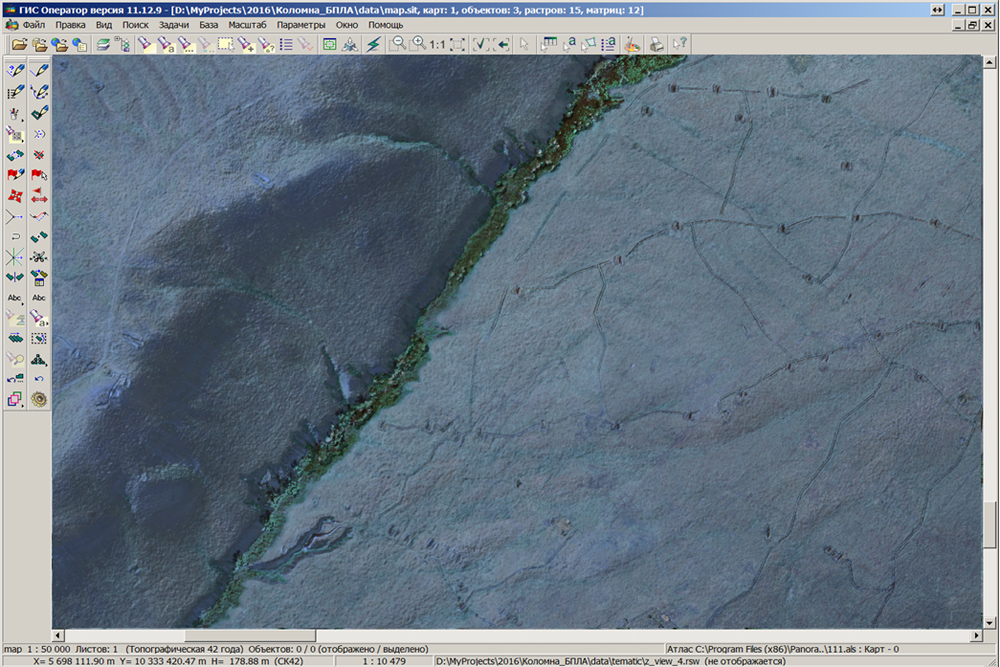
Specialists of KB "Panorama" took part in annual scientifical-practical branch conference the . The event was held on March 18, 2016 in the town of Kolomna on the basis of the National Centre for unmanned aircraft. At conference the report was presented on the topic "Application of GIS "Operator" in complexes with UAVs for operative processing and analysis of geo-information data".
The conference was organized by the Center (research, combat deployment and military trials of unmanned aircraft). Taking into account the specifics of the event and staff of participants, in the report there were covered the issues of increasing the efficiency of using the digital terrain information in the automated command and control systems, navigation systems, means of combat defeat at pointing at the target and in simulators. For survey orientation on the ground a single cartographical basis, presented by a tile geo-covering can be used. has the embedded tools of displaying a current location on the basis of information incoming from GLONASS receiver connected to your computer and building routes of moving of complexes of management and flights routes of unmanned aerial vehicles on the basis of the analysis of special digital model the "Roads graph".
GIS "Operator" provides rapid processing of photographic materials coming from the UAV, as "block layout" displayed on the background of image of a single cartographical basis. This allows you to quickly assess areas, to receive and process the intelligence data. Exact processing of photographic materials and obtaining of orthophotomaps is carried out by photogrammetric complexes. The received images in GeoTIFF format are opened in the environment of GIS "Operator" with an automatic reference to the terrain. Thus, the program "on the fly" reprojected an orthophotomap at adding to a single cartographical basis. Integrated use of orthophotomaps and a matrix of elevation of a relief allows to synthesise in an environment of GIS "Operator" the image of area displaying the forms of a relief together with the image of area for a visual assessment of the terrain and performance of calculating and analytical tasks.


Ph.: +7 (495) 739-0245, +7 (925) 221-1603
www.gisinfo.ru | panorama@gisinfo.ru
105005, Russia, Moscow, Baumanskaya Street 7, building 1, office 229 (m. Baumanskaya)
Copyright © Panorama Group 1991 - 2024


 Mobile version
 Full version