Copyright © Panorama Group 1991 - 2024

In KB "Panorama" the of version 11.13.2 for Astra Linux SE operating system is developed. In the new version the possibilities of the task "Building a profile" are expanded : the mode is added for saving the graph into files of formats BMP, PNG, JPEG; displaying on the graph of crossed objects is added; there is added an automatic calculation of heights of extreme points from which the direct visibility is provided; tools of calculating Z-offset are developed. For the task's mode "Road net" there is developed a formation of a path route with the established kilometer marks. Into the task "Buffer zone" the possibility of constructing a zone in the closed map object is added.
The military-oriented GIS "Operator" was adopted to supply the Armed Forces of the Russian Federation by the order of the Minister of Defence of the Russian Federation and is certified in system of certification of information security tools for information security requirements.
The new version of the program is available for download in the .


Specialists of KB "Panorama" took part in annual scientifical-practical branch conference the . The event was held on March 18, 2016 in the town of Kolomna on the basis of the National Centre for unmanned aircraft. At conference the report was presented on the topic "Application of GIS "Operator" in complexes with UAVs for operative processing and analysis of geo-information data".
The conference was organized by the Center (research, combat deployment and military trials of unmanned aircraft). Taking into account the specifics of the event and staff of participants, in the report there were covered the issues of increasing the efficiency of using the digital terrain information in the automated command and control systems, navigation systems, means of combat defeat at pointing at the target and in simulators. For survey orientation on the ground a single cartographical basis, presented by a tile geo-covering can be used. has the embedded tools of displaying a current location on the basis of information incoming from GLONASS receiver connected to your computer and building routes of moving of complexes of management and flights routes of unmanned aerial vehicles on the basis of the analysis of special digital model the "Roads graph".
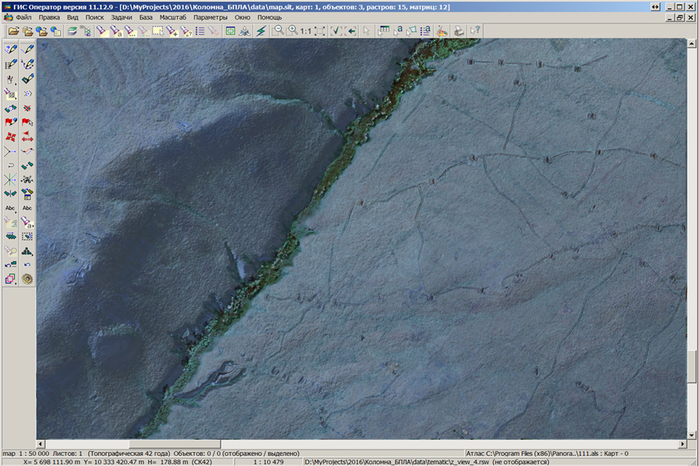
GIS "Operator" provides rapid processing of photographic materials coming from the UAV, as "block layout" displayed on the background of image of a single cartographical basis. This allows you to quickly assess areas, to receive and process the intelligence data. Exact processing of photographic materials and obtaining of orthophotomaps is carried out by photogrammetric complexes. The received images in GeoTIFF format are opened in the environment of GIS "Operator" with an automatic reference to the terrain. Thus, the program "on the fly" reprojected an orthophotomap at adding to a single cartographical basis. Integrated use of orthophotomaps and a matrix of elevation of a relief allows to synthesise in an environment of GIS "Operator" the image of area displaying the forms of a relief together with the image of area for a visual assessment of the terrain and performance of calculating and analytical tasks.


KB "Panorama" developed , GIS "Panorama FARMING", GIS "Panorama AUTO" version 4.8. The new version provides calculation of the distance traveled by technique regardless of the type of onboard navigation equipment.
The range of agrarian geoinformation products includes the GIS "Panorama AGRO", GIS "Panorama FARMING", GIS "Panorama AUTO", "Workstation of agronomist", GIS WebServer AGRO. is applied for ensuring the authorised access to the cartographical information. Monitoring the progress of field work, analysis of the effectiveness of the using the technical means and performed mechanized operations are carried out on the basis of satellite positioning.
The navigation subsystem as one of components is embedded into agricultural GIS and includes tools for the automated accounting the farming operations. Gathering information for the functioning of the system is carried out automatically. Information about mobile objects is placed into the database of system and are processed by the program on specific algorithms. All measurements have coordinates and time of registration. As a result the program conducts the automatic registration of mechanized operations, calculates the processed areas, the traveled distance, the amount of the applied fertilizers, assesses the quality of performed works and allows to correlate the actual data with the planned agro-technical activities.
Construction of agrarian GIS on the basis of technology of integrated use of remote sensing data and results of satellite navigation measurements shows high efficiency of managing the agronomic activities and provides reliable control of technology of cultivation of agricultural crops.
New versions of programs are available for download in the section.


Specialists of KB "Panorama" made updating the classifier for maps of public sources (OpenStreetMap). Changes are made in the appearance of the objects of the road network and streets that are displayed in two lines. Specified objects are customized by means of the new style "Line with a contour". The classifier with new styles is available when working in programs the and . The classifier is intended for use with data OpenStreetMap, and also for using the "Technology of import of spatial data from public sources".
On page "Digital maps and images" there are available for download the maps in format SXF, generated on the basis of OpenStreetMap data. For work with these maps you can use . To form and support in an actual state the storehouse of spatial data including digital maps in format SXF, it is possible by means of program Osmloader.
Classifier is available for downloading on pages the "Classifiers" and "Digital maps and images".

Geoportal updated the map of Sakhalin region formed according to OpenStreetMap data. Source data obtained from the website are complemented by objects from maps of scale 1: 1 000 000. There are added the objects of hydrography, vegetation, road network. For work with the received map it is possible to use the program of or other software products of KB "Panorama".
Publishing of updates in bank of spatial data is made by using the program of Complex of conducting a databank of digital maps and remote sensing data. Publishing contents of bank of spatial data on the geoportal and data access for downloading are implemented by means of GIS WebServer SE.
Free maps on the basis of OpenStreetMap data are available for download on the page "Digital maps and images".
Ph.: +7 (495) 739-0245, +7 (925) 221-1603
www.gisinfo.ru | panorama@gisinfo.ru
105005, Russia, Moscow, Baumanskaya Street 7, building 1, office 229 (m. Baumanskaya)
Copyright © Panorama Group 1991 - 2024


 Mobile version
 Full version